
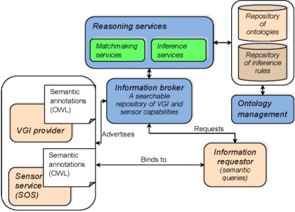
The increasing availability of sensor devices has resulted in large volumes of sensor data, which has raised the issue of making these data fully discoverable and interpretable by applications and end-users. The idea of OGC Sensor Web Enablement (SWE) has addressed this issue by proposing a set of standards to enable accessibility of sensor data over the Web. Similarly, there is a growing interest in volunteered geographic information (VGI). Considering that several researchers have highlighted the potential of this new type of information as a complement to existing, “traditional” data, it becomes important to develop frameworks to support the integration of VGI from several sources and with other types of data. In this paper, we make a first step in this direction by proposing a framework for the interoperability of sensor data and VGI. After having performed an investigation of the types of VGI applications, we have developed a conceptual model of VGI aligned with relevant ISO standards for describing geospatial features. The purpose of this model is to support the generation of common descriptions for VGI applications, which will act as interfaces to higher-level services, such as discovery and reasoning services, in order to be exploited in conjunction with sensor data by client applications. Details of this inital steps are discussed in this paper in the ISPRS Int. Journal of Geoinformation.
Towards interoperability between data from technical sensors and human sensors (VGI)
by
Tags: