• Home
  • About

GIScience News Blog

News of Heidelberg University’s GIScience Research Group.

Feed on
Posts
Comments
« Open Position Scientist / PostDoc: “People as Sensors”
Young Mappers: Practical OSM Intro for Children at “KinderUni” Heidelberg »

GIS-Based Roughness Derivation for Flood Simulations

Feb 27th, 2014 by hs090

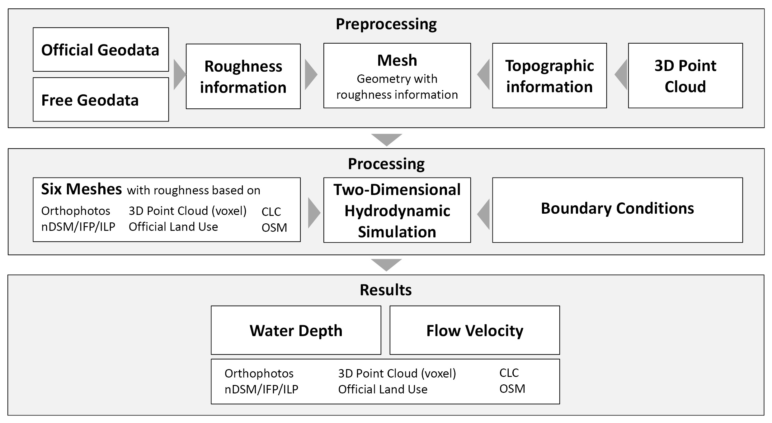
Natural disasters like floods are a worldwide phenomenon and a serious threat to mankind. Flood simulations are applications of disaster control, which are used for the development of appropriate flood protection. Adequate simulations require not only the geometry but also the roughness of the Earth’s surface, as well as the roughness of the objects hereon. Usually, the floodplain roughness is based on land use/land cover maps derived from orthophotos. This study analyses the applicability of roughness map derivation approaches for flood simulations based on different datasets: orthophotos, LiDAR data, official land use data, OpenStreetMap data and CORINE Land Cover data. Object-based image analysis is applied to orthophotos and LiDAR raster data in order to generate land cover maps, which enable a roughness parameterization. The vertical vegetation structure within the LiDAR point cloud is used to derive an additional floodplain roughness map. Further roughness maps are derived from official land use data, OpenStreetMap and CORINE Land Cover datasets. Six different flood simulations are applied based on one elevation data but with the different roughness maps. The results of the hydrodynamic–numerical models include information on flow velocity and water depth from which the additional attribute flood intensity is calculated of. The results based on roughness maps derived from LiDAR data and OpenStreetMap data are comparable, whereas the results of the other datasets differ significantly.

Dorn, H., Vetter, M. & Höfle, B. (2014): GIS-Based Roughness Derivation for Flood Simulations: A Comparison of Orthophotos, LiDAR and Crowdsourced Geodata. Remote Sensing. Vol. 6(2), pp. 1739-1759. DOI:10.3390/rs6021739

Tags: ALS point cloud, hydraulic modeling, land use/land cover classification, OpenStreetMap

Posted in Publications

Comments are closed.

  • About

    GIScience News Blog
    News of Heidelberg University’s GIScience Research Group.
    There are 1,462 Posts and 0 Comments so far.

  • Meta

    • Log in
    • Entries RSS
    • Comments RSS
    • WordPress.org
  • Recent Posts

    • Updated OSM Healthcare in Senegal (2020)
    • Find the route to your nearest Covid-19 vaccination center in Germany — new App by HeiGIT based on OpenStreetMap and openrouteservice
    • ohsome street network analysis part 1
    • Keynote at McGILL GIS DAY: Analysing and Improving OpenStreetMap for Humanitarian Aid with Data Mining and GeoAI
    • Update on “Accessibility of COVID-19 vaccination centers in Germany”
  • Tags

    3D 3DGEO Big Spatial Data CAP4Access Citizen Science Colloquium crisis mapping Crowdsourcing data quality disaster DisasterMapping GeoNet.MRN GIScience heigit HOT humanitarian Humanitarian OpenStreetMap team intrinsic quality analysis landuse laser scanning Lidar Mapathon MapSwipe Missing Maps MissingMaps ohsome ohsome example Open data openrouteservice OpenStreetMap OSM OSM History Analytics OSMlanduse Quality quality analysis remote sensing routing social media spatial analysis Teaching terrestrial laser scanning Twitter VGI Wheelchair Navigation Workshop
  • Archives

    • January 2021
    • December 2020
    • November 2020
    • October 2020
    • September 2020
    • August 2020
    • July 2020
    • June 2020
    • May 2020
    • April 2020
    • March 2020
    • February 2020
    • January 2020
    • December 2019
    • November 2019
    • October 2019
    • September 2019
    • August 2019
    • July 2019
    • June 2019
    • May 2019
    • April 2019
    • March 2019
    • February 2019
    • January 2019
    • December 2018
    • November 2018
    • October 2018
    • September 2018
    • August 2018
    • July 2018
    • June 2018
    • May 2018
    • April 2018
    • March 2018
    • February 2018
    • January 2018
    • December 2017
    • November 2017
    • October 2017
    • September 2017
    • August 2017
    • July 2017
    • June 2017
    • May 2017
    • April 2017
    • March 2017
    • February 2017
    • January 2017
    • December 2016
    • November 2016
    • October 2016
    • September 2016
    • August 2016
    • July 2016
    • June 2016
    • May 2016
    • April 2016
    • March 2016
    • February 2016
    • January 2016
    • December 2015
    • November 2015
    • October 2015
    • September 2015
    • August 2015
    • July 2015
    • June 2015
    • May 2015
    • April 2015
    • March 2015
    • February 2015
    • January 2015
    • December 2014
    • November 2014
    • October 2014
    • September 2014
    • August 2014
    • July 2014
    • June 2014
    • May 2014
    • April 2014
    • March 2014
    • February 2014
    • January 2014
    • December 2013
    • November 2013
    • October 2013
    • September 2013
    • August 2013
    • July 2013
    • June 2013
    • May 2013
    • April 2013
  •  

    February 2014
    M T W T F S S
    « Jan   Mar »
     12
    3456789
    10111213141516
    17181920212223
    2425262728  
  • Recent Comments

    GIScience News Blog CC by-nc-sa Some Rights Reserved.

    Free WordPress Themes | Fresh WordPress Themes