
Identifying and characterizing variations of human activity – specifically changes in intensity and similarity – in urban environments provide insights into the social component of those eminently complex systems. Using large volumes of user-generated mobile phone data, we derive mobile communication profiles that we use as a proxy for the collective human activity. In this paper, geocomputational methods and geovisual analytics such as Self-Organizing Maps SOM are used to explore the variations of these profiles, and its implications for collective human activity. We evaluate the merits of SOM as a cross-dimensional clustering technique and derived temporal trajectories of variations within the mobile communication profiles. The trajectories’ characteristics such as length are discussed, suggesting spatial variations in intensity and similarity in collective human activity. Trajectories are linked back to the geographic space to map the spatial and temporal variation of trajectory characteristics. Different trajectory lengths suggest that mobile phone activity is correlated with the spatial configuration of the city, and so at different times of the day. Our approach contributes to the understanding of the space-time social dynamics within urban environments.
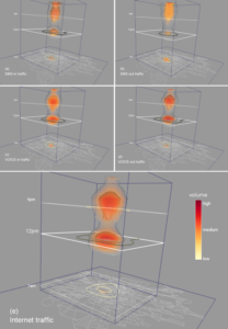
- 3D visualization of mobile phone activity

Reference
Sagl, G., Delmelle, E., and Delmelle, E. (2014) Mapping collective human activity in an urban environment based on mobile phone data. Cartography and Geographic Information Science, pp. 1-14.