
Watch out”
New video tutorials of “how to use our LVISA system” are available at http://www.youtube.com/user/TheLRGHeidelberg
The videos give an introduction of the general usage of LVISA as well as an introduction of the visualization, exploration and analysis of LVISA reference data as well as of own (external) data.
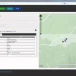
LVISA is a novel system for analyzing point clouds of vegetation. This system constitutes a web-based Laser Scanning (LS) database for the management and analysis of reference signatures. It combines the techniques and methods of LiDAR and 3D GIScience. LVISA is embedded in the LS-VISA project of the Lidar Research Group Heidelberg.