
With the Geo-reCAPTCHA we present a new concept for crowdsourcing of vast amounts of geoinformation by micro-mapping tasks.

The paper can be downloaded free of charge (until 22 May 2015).
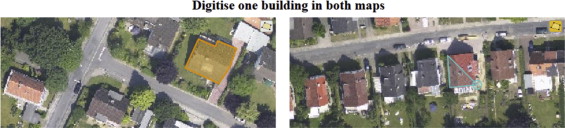
In our study we investigated the possibilities and limitations of capturing building footprints via Geo-reCAPTCHA based on remote sensing imagery. We could analyze more than 2200 individual digitizations and conclude that all technical requirements are addressed in our Geo-reCAPTCHA system design. Thus, Geo-reCAPTCHA offers an appropriate alternative to reCAPTCHA regarding CAPTCHA security as well as the resulting data quality.
Above that, there are further geographic applications and potential use cases in which data from Geo-reCAPTCHA could be integrated. One use case could be to contribute to the digitization of base maps in crisis-prone parts of the worlds where maps are missing. Moreover, Geo-reCAPTCHA could be used to classify remote sensing data. For example, Geo-Wiki could utilize Geo-reCAPTCHA to update the global land cover classification by presenting random parts of satellite images in which the predominant land cover class (e.g., forests, agricultural, or urban areas) should be digitized. Beyond that, even 3D earth observation data in the form of laser scanning point cloud data can be classified by identifying objects within the point cloud (e.g., a house or a tree) using Geo-reCAPTCHA. These LiDAR datasets are particularly relevant for establishing reference object libraries, such as for vegetation objects where the large amount of reference object features improves automatic 3D tree characterization.
Reference
Hillen, F. & Höfle, B. (2015): Geo-reCAPTCHA: Crowdsourcing large amounts of geographic information from earth observation data. International Journal of Applied Earth Observation and Geoinformation. Vol. 40 (0), pp. 29-38.