New DAAD/MOST project will enable intensive exchange between Taiwan and Germany in 2016-17
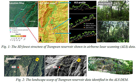
The main scientific objective of 3D-TAIGER‘s exchange and collaborative research is the development of new methods for the automatic extraction of 3D geoinformation related to forests and natural hazards in Taiwan using multi-source remote sensing data.
The project 3D-TAIGER is an international research collaboration and networking activity between the Institute of Geography, GIScience, LiDAR Research Group (LRG) of the Heidelberg University (HU) and the Department of Geomatics and Department of Earth Sciences of the National Cheng Kung University (NCKU) in Tainan/Taiwan. It is funded jointly by the DAAD (Germany) and MOST (Taiwan).
LVISA goes Taiwan
One specific outcome of this project will be the extension of the International LiDAR Vegetation Signature Database – LVISA (http://www.uni-heidelberg.de/lvisa) hosted at GIScience Heidelberg, which contains tree species LiDAR information. LVISA will be extended with ALS reference signatures covering Taiwan’s most prominent tree species. Further, LVISA’s Web analysis tools will be extended to support carbon contribution estimation by NCKU.