Now the book “Spatial Information Theory” has been published in electronic and print format. It includes full papers from the COSIT – CONFERENCE ON SPATIAL INFORMATION THEORY XII 2015, including our paper:
Ballatore, A. and Zipf, A. (2015): A Conceptual Quality Framework for Volunteered Geographic Information. In: Fabrikant, S.I., Raubal, M., Bertolotto, M., Davies, C., Freundschuh, S., Bell, S. (Eds.): Spatial Information Theory. 12th International Conference, COSIT 2015, Santa Fe, NM, USA, October 12-16, 2015, Proceedings. Lecture Notes in Computer Science, pp. 89-107.
The assessment of the quality of volunteered geographic information (VGI) is cornerstone to understand the fitness for purpose of datasets in many application domains. While most analyses focus on geometric and positional quality, only sporadic attention has been devoted to the interpretation of the data, i.e., the communication process through which consumers try to reconstruct the meaning of information intended by its producers. Interpretability is a notoriously ephemeral, culturally rooted, and context-dependent property of the data that concerns the conceptual quality of the vocabularies, schemas, ontologies, and documentation used to describe and annotate the geographic features of interest.
To operationalize conceptual quality in VGI, we propose a multi-faceted framework that includes accuracy, granularity, completeness, consistency, compliance, and richness, proposing proxy measures for each dimension.
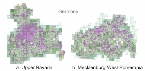
The application of the framework is illustrated in a case study on a European sample of OpenStreetMap, focused specifically on conceptual compliance.