• Home
  • About

GIScience News Blog

News of Heidelberg University’s GIScience Research Group.

Feed on
Posts
Comments
« OpenRouteService Update 3.1 - with Surface Information and more!
GIScience HD re-united in new office building (new address!) »

disastermappers heidelberg and GIScience meeting Missing Maps in London to foster collaboration and partnership

Apr 12th, 2016 by Carolin Klonner

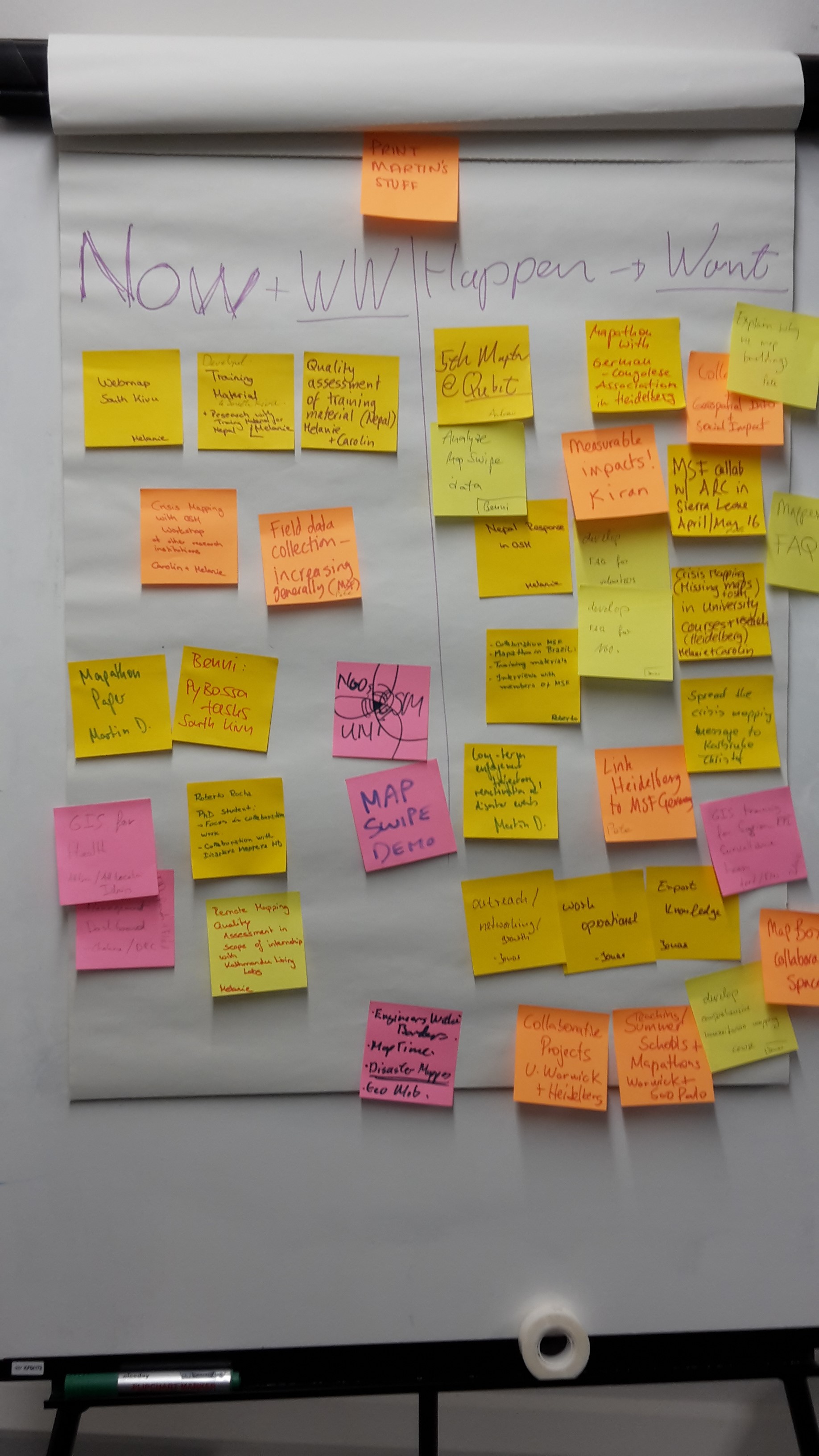
Last week, Carolin Klonner, Benjamin Herfort, Melanie Eckle (GIScience Heidelberg and disastermappers heidelberg), Svend-Jonas Schelhorn, Christof Nichterlein (disastermappers heidelberg), Prof. Dr. João Porto de Albuquerque (GIScience Heidelberg and Centre for Interdisciplinary Methodologies, University of Warwick) and Roberto Rocha (University of Münster) travelled to London to meet the Missing Maps team.

During a one and a half day intensive creative workshop with the Missing Maps team, members of Médecines Sans Frontiéres UK and the British Red Cross insights of the work of each partner were given. A brainstorming session facilitated the identification of core tasks and possible contributions of the workshop participants.

//twitter.com/dekstop/status/716960412210753536)

Meeting with Missing Maps (https://twitter.com/dekstop/status/716960412210753536)

Brainstorming

Brainstorming

On the following day, the team was invited to the British Red Cross to learn more about the practices and projects of the BRC and how their work is supported by the Missing Maps project. The discussions showed that geodata quality is crucial when estimating population distribution or planning vaccination campaigns. The knowledge and work of the GIScience research group on crowdsourcing and VGI in general and OpenStreetMap data quality in particular can be very valuable in this context. The meetings were complemented with the monthly Missing Maps mapathon - one of the large scale mapathons organized by Missing Maps in varying venues all over London with about 80 participants.

//twitter.com/Disastermappers/status/717418900305084416)

Mapathon (https://twitter.com/Disastermappers/status/717418900305084416)

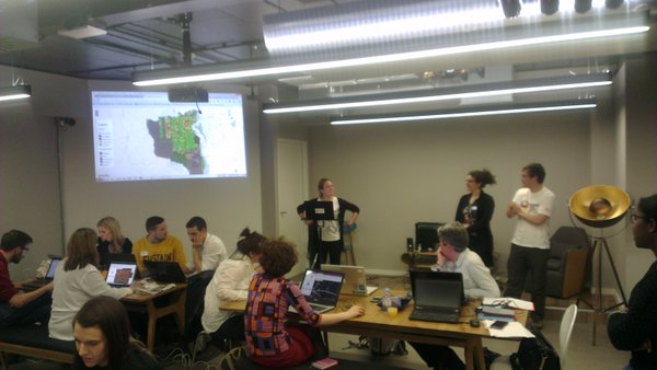
We learned how to handle mapathons with a large number of participants and gathered new ideas for own mapathons in Heidelberg. Moreover, the event provided a chance to present our work and research to the wider Missing Maps community and the present members of the Humanitarian OpenStreetMap team.

To further support the Missing Maps project we are open minded to support related bachelor or master theses. Furthermore, there will be several courses at the GIScience department in the coming semester dealing with topics also linked to the Missing Maps project.

Latest research concerning Missing Maps and humanitarian mapping from the GIScience research group include:

Anhorn, J., Herfort, B., de Albuquerque, J. P., (2016): Crowdsourced Validation and Updating of Dynamic OSM Features: A Nepal Earthquake Case Study. 13th International Conference on Information Systems for Crisis Response and Management. ISCRAM 2016. Rio de Janeiro, Brazil.

Herfort, B., Eckle, M., de Albuquerque, J. P., (2016): Being specific about geographic information crowdsourcing: a typology and analysis of the Missing Maps project in South Kivu. 13th International Conference on Information Systems for Crisis Response and Management. ISCRAM 2016. Rio de Janeiro, Brazil.

Tags: crisis mapping, DisasterMapping, MissingMaps, OpenStreetMap, OSM, VGI

Posted in Events, OSM, VGI Group

Comments are closed.

  • About

    GIScience News Blog
    News of Heidelberg University’s GIScience Research Group.
    There are 1,136 Posts and 11 Comments so far.

  • Meta

    • Log in
    • Entries RSS
    • Comments RSS
    • WordPress.org
  • Recent Posts

    • HeiGIT and Humanitarian OpenStreetMap Team at the Geospatial World Forum 2019 in Amsterdam
    • Mapping ecosystem services – the example of crop pollination
    • Using Openrouteservice in the data science platform alteryx
    • OpenStreetMap history explorer - ohsomeHeX published
    • VGI-HATcH: Workshop at AGILE 2019 in Limassol, Cyprus (June 17, 2019)
  • Tags

    3D AGILE Big Spatial Data CAP4Access Citizen Science Colloquium crisis mapping Crowd Analyser Crowdsourcing data quality disaster DisasterMapping GeoNet.MRN GIScience heigit humanitarian Humanitarian OpenStreetMap team intrinsic quality analysis landuse laser scanning Lidar Mapathon MapSwipe Missing Maps MissingMaps ohsome Open data OpenRouteService OpenStreetMap OSM OSM History Analytics OSMlanduse Quality quality analysis remote sensing routing social media spatial analysis Teaching Twitter VGI WebGIS wheelchair Wheelchair Navigation Workshop
  • Archives

    • February 2019
    • January 2019
    • December 2018
    • November 2018
    • October 2018
    • September 2018
    • August 2018
    • July 2018
    • June 2018
    • May 2018
    • April 2018
    • March 2018
    • February 2018
    • January 2018
    • December 2017
    • November 2017
    • October 2017
    • September 2017
    • August 2017
    • July 2017
    • June 2017
    • May 2017
    • April 2017
    • March 2017
    • February 2017
    • January 2017
    • December 2016
    • November 2016
    • October 2016
    • September 2016
    • August 2016
    • July 2016
    • June 2016
    • May 2016
    • April 2016
    • March 2016
    • February 2016
    • January 2016
    • December 2015
    • November 2015
    • October 2015
    • September 2015
    • August 2015
    • July 2015
    • June 2015
    • May 2015
    • April 2015
    • March 2015
    • February 2015
    • January 2015
    • December 2014
    • November 2014
    • October 2014
    • September 2014
    • August 2014
    • July 2014
    • June 2014
    • May 2014
    • April 2014
    • March 2014
    • February 2014
    • January 2014
    • December 2013
    • November 2013
    • October 2013
    • September 2013
    • August 2013
    • July 2013
    • June 2013
    • May 2013
    • April 2013
  •  

    April 2016
    M T W T F S S
    « Mar   May »
     123
    45678910
    11121314151617
    18192021222324
    252627282930