When producing optimal routes through an environment, considering the incline of surfaces can be of great benefit in a number of use cases. For instance, incline may be considered when computing the most energy-efficient routes for electric cars and bicycles. Likewise, pedestrians with restricted mobility (such as wheelchair users, parents with pushchairs, and the elderly) often have to and/or want to avoid steep ways. Such incline information may be derived from different types of digital elevation models (DEM). However, the corresponding data capturing methods (e.g. airborne LiDAR, photogrammetry, terrestrial surveying) are expensive. Current low cost and open licensed DEM (e.g. SRTM, ASTER) generally do not have sufficient horizontal resolution or vertical accuracy, and lack a global coverage (in the case of regional open government data).
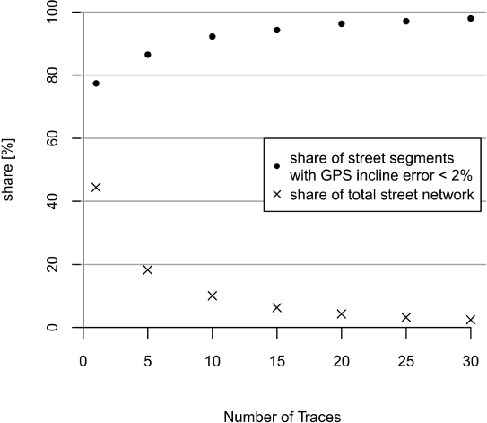
Therefore, we have investigated an alternative low-cost approach which derives street incline values from GPS traces that have been voluntarily collected by the OpenStreetMap (OSM) contributors. Despite the poor absolute accuracy of this data, the relative accuracy of traces seems to be sufficient enough to compute incline values with reasonable accuracy. A validation shows that the accuracy of incline values calculated from GPS traces slightly outperforms incline values derived from SRTM-1 DEM in terms of accuracy. However, results depend on how many traces per street segment are used for computation. For instance, in the case of at least 5 GPS traces per segment, we find that the incline (measured in %) may be computed with a standard deviation of σGPS = 1.6 % (σSRTM = 3.1 %). However, this comes at the cost of incomplete coverage – only 18% of the street network in our study region Heidelberg is covered by at least 5 traces.
John, S.; Hahmann, S.; Rousell, A.; Löwner, M.-O. and Zipf, A. (2016): Deriving incline values for street networks from voluntarily collected GPS traces. Cartography and Geographic Information Systems. dx.doi.org/10.1080/15230406.2016.1190300
There are 50 eprints of the article available – feel free to grab one (while stocks last) in case your institution does not provide you access. Alternatively, you may access the author manuscript (version as accepted).
This research can be reproduced using the source of our github repository and the OpenStreetMap planet GPS files. The application of the respective tools ([1], [2], [3], [4]) is described in the article.