
Today a new global WebMap prototype “OSMLanduse.org” has been launched by GIScience Research Group Heidelberg. The map provides worldwide Landuse/Landcover information on the basis of OpenStreetMap (OSM) data. This is based on our earlier work on testing the suitability of OpenStreetMap for deriving landuse and landcover information (LULC).
LULC data is highly relevant for many research questions and practical planning activites.
Up to now there exist well known data sets generated from remote sensing imagery such as CORINE, Urban Atlas or GlobeLand30, which are available for different areas, time slots, and offer different LULC classifications.
Yet it is an interesting question if and to what degree OpenStreetMap can complement, add to, or refine these sources. Up to now this is certainly very different in different world regions and the new map helps to explore and better understand this kind of data in OSM and how it is evolving in different areas.
Therefore our aim is to evaluate the overall possibility and suitability of OpenStreetMap (OSM) data for these specific purposes, identify ways for improvement and to provide all this information globally to the interested communities in an automated way.
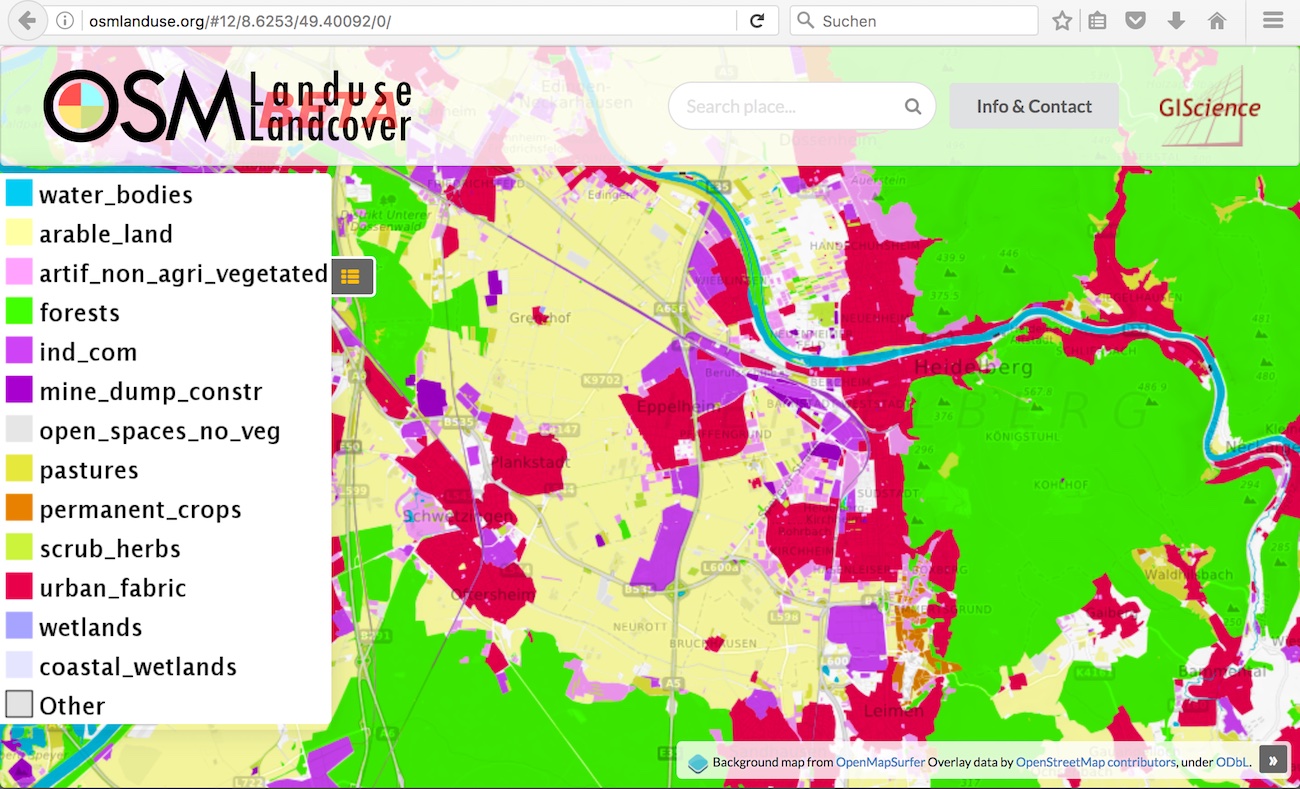
In order to do so, the data from OpenStreetMap, stored in Key-Value pairs, was initially categorized similar to the classification level 2 of the CORINE Landcover classes. This category mapping and further pre-processing of OSM data will be further refined in ongoing work.
We then set up a first basic WebMapping application with the use of free and open-source software, including PostgreSQL/PostGIS, Geoserver and MapProxy.
At the moment the website provides basic WebGIS elements, such as legend, search function and feature info. Higher zoomlevels (>7) are updated on a minutely basis. In the near future we want to implement other useful features and explore ways to measure the quality of the data.
Right now we are working on realizing a function, which provides statistical information about the landuse/landcover in a certain area (bbox), defined by the user.
In particular we also do further refine the mapping between common land use classifications such as CORINE, Urban Atlas etc. and the OpenStreetMap categorization of objects and improve the preprocessing for different scales etc.
So stay tuned for further updates!
http://osmlanduse.geog.uni-heidelberg.de/ == http://osmlanduse.org/
This work has kindly been supported by the Klaus Tschira Foundation (KTS) Heidelberg in the context of establishing the Heidelberg Institute for Geoinformation Technology (HeiGIT).
Earlier Work:
Jokar Arsanjani, J., Mooney, P., Zipf, A., Schauss, A., (2015): Quality assessment of the contributed land use information from OpenStreetMap versus authoritative datasets. In: Jokar Arsanjani, J., Zipf, A., Mooney, P., Helbich, M., OpenStreetMap in GIScience: experiences, research, applications. ISBN:978-3-319-14279-1, PP. 37-58, Springer Press.
Jokar Arsanjani, J., Helbich, M., Bakillah, M., Hagenauer, J., & Zipf, A. (2013). Toward mapping land-use patterns from volunteered geographic information. International Journal of Geographical Information Science, 2264-2278. DOI:10.1080/13658816.2013.800871.
Dorn, H., Törnros, T. & Zipf, A. (2015): Quality Evaluation of VGI using Authoritative Data – A Comparison with Land Use Data in Southern Germany. ISPRS International Journal of Geo-Information. Vol 4(3), pp. 1657-1671, doi: 10.3390/ijgi4031657
Hagenauer, J. & Helbich, M. (2012): Mining urban land use patterns from volunteered geographic information using genetic algorithms and artificial neural networks. International Journal of Geographical Information Science (IJGIS). Taylor & Francis. DOI:10.1080/13658816.2011.619501.
Ballatore, A. and Zipf, A. (2015): A Conceptual Quality Framework for Volunteered Geographic Information. COSIT – CONFERENCE ON SPATIAL INFORMATION THEORY XII. October 12-16, 2015. Santa Fe, New Mexico, USA. Lecture Notes in Computer Science, pp. 1-20.
Törnros, T., Dorn, H., Hahmann, S., and Zipf, A. (2015): Uncertainties of completeness measures in OpenStreetMap – A Case Study for buildings in a medium-sized German city, ISPRS Ann. Photogramm. Remote Sens. Spatial Inf. Sci., II-3/W5, 353-357, doi:10.5194/isprsannals-II-3-W5-353-2015.
Fan H., Zipf A., Fu Q. and Neis P. 2014. Quality assessment for building footprints data on OpenStreetMap. In: International Journal of Geographical Information Science. DOI: 10.1080/13658816.2013.867495