
The Special Issue on “Crowdsourced Mapping” of the international journal “Cartography and Geographic Information Science” is online. Here you can read the editorial.
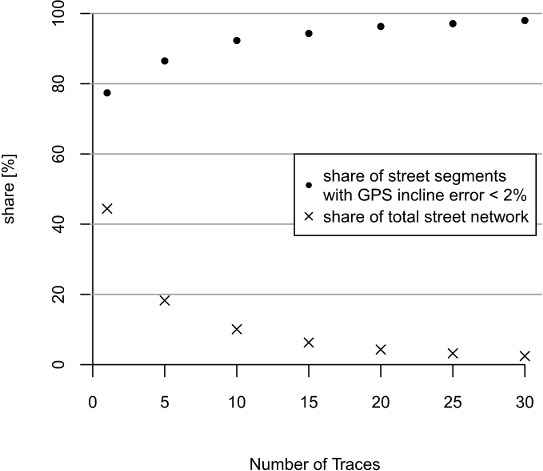
Further this issue includes our paper on Deriving incline values for street networks from voluntarily collected GPS traces. When producing optimal routes through an environment, considering the incline of surfaces can be of great benefit in a number of use cases. For instance, steep segments need to be avoided for energy-efficient routes and for routes that are suitable for mobility-restricted people. Therfore we have investigated an low-cost approach which derives street incline values from GPS traces that have been voluntarily collected by the OpenStreetMap contributors. Despite the poor absolute accuracy of this data, the relative accuracy of traces seems to be sufficient enough to compute incline values with reasonable accuracy. A validation shows that the accuracy of incline values calculated from GPS traces slightly outperforms incline values derived from SRTM-1 DEM, though results depend on how many traces per street segment are used for computation.

John, S.; Hahmann, S.; Rousell, A.; Löwner, M.-O. and Zipf, A. (2016): Deriving incline values for street networks from voluntarily collected GPS traces. Cartography and Geographic Information Systems. Vol 40. Issue 2. Pages 152-169. dx.doi.org/10.1080/15230406.2016.1190300