• Home
  • About

GIScience News Blog

News of Heidelberg University’s GIScience Research Group.

Feed on
Posts
Comments
« Prize of “Runder Tisch GIS” for GIScience Master Thesis on Geospatial Analysis of the German Software Industry (Jan Kinne, Heidelberg)
Crazy Times in Heidelberg »

Towards a Landmark based pedestrian Navigation Service using OpenStreetMap data

Feb 26th, 2017 by GIScienceHD

Within wayfinding and navigation tasks, the use of landmarks has been found to be a key aspect. In particular pedestrian instructions should focus on the delivery of “landmarks” to aid in navigation. Still the use of landmarks is not common in many navigation systems. The salience of features is an important aspect of whether they can be used as landmarks. OpenStreetMap (OSM) contains a vast amount of geospatial information that can be tapped into for identifying these landmark features. A recently published paper (Rousell & Zipf 2017) presents a prototype navigation service extending OpenRouteService (Schmitz et al. 2008) that extracts landmarks suitable for navigation instructions from the OSM dataset based on several metrics.
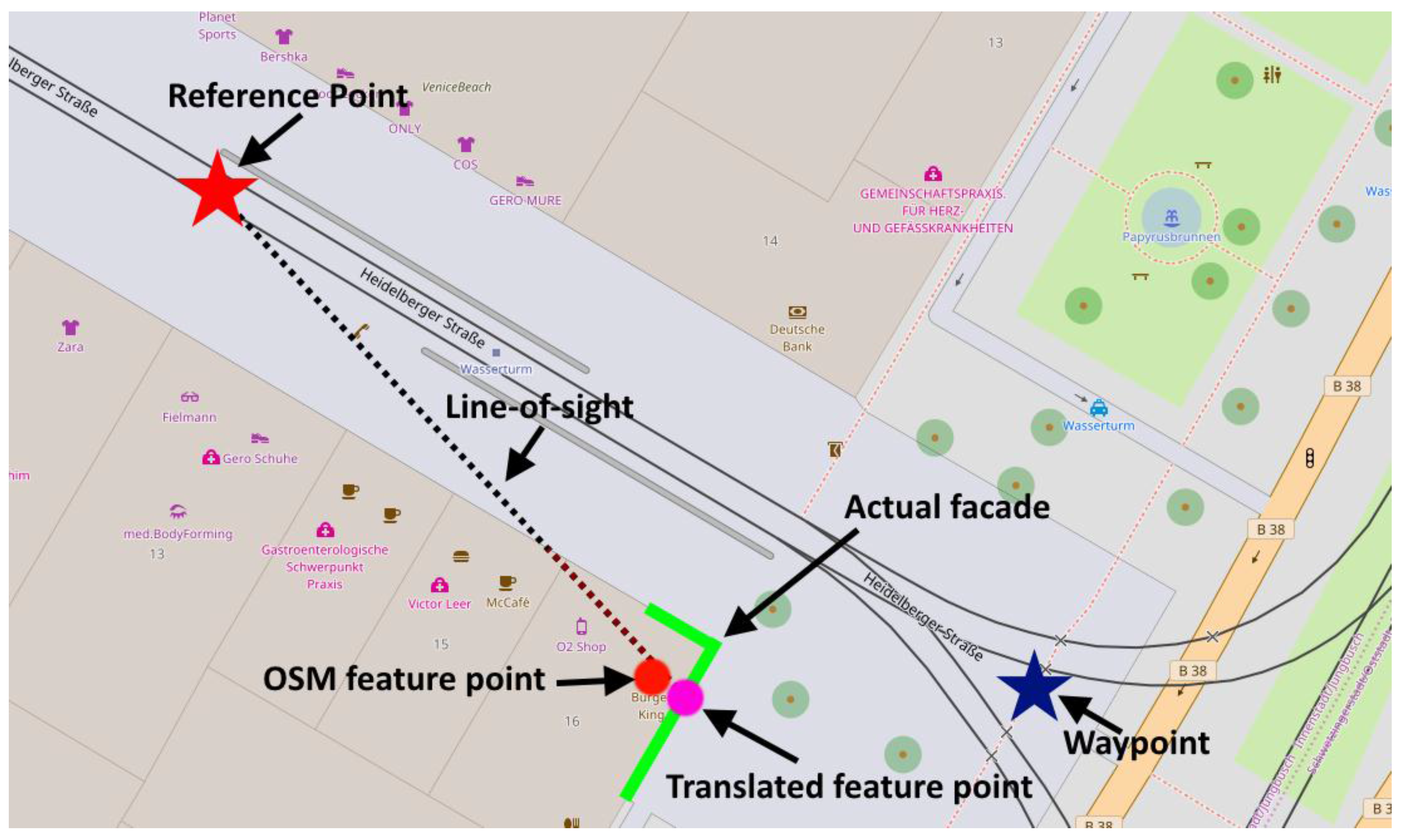
As identified in the literature, it is clear that to successfully extract landmarks from a set of features, it is important to take into account several characteristics, such as distance from the decision point and the visual saliency of the feature. Based on the prior literature, several methods have been implemented within the navigation service currently being developed in an attempt to identify and deliver landmarks in routing instructions. Using OSM the landmark identification process implemented in this prototype focusses on the identification of six primary attributes of a landmark candidate:
visual/semantic saliency, distance from waypoint, visibility, position, location, and uniqueness.
All of the required information is available from the OSM dataset. All calculations are performed automatically and require no additional input other than this single dataset.
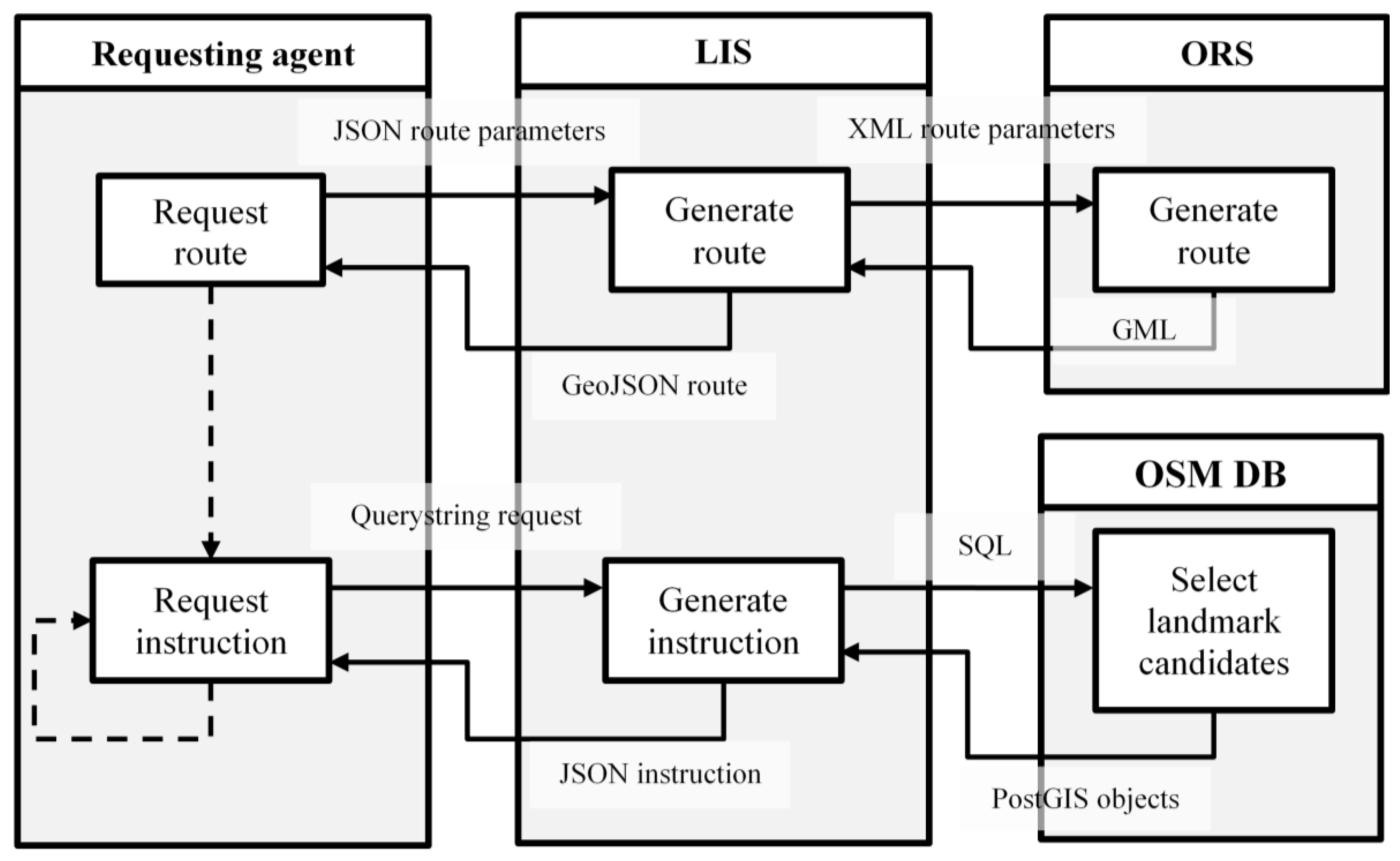
This is coupled with a short comparison of landmark availability within OSM, differences in routes between locations with different levels of OSM completeness and a short evaluation of the suitability of the landmarks provided by the prototype. Landmark extraction is performed on a server-side service, with the instructions being delivered to a pedestrian navigation application running on an Android mobile device.

Rousell A. and Zipf A. (2017): Towards a landmark based pedestrian navigation service using OSM data. International Journal of Geo-Information, ISPRS IJGI. 6(3), 64; doi:10.3390/ijgi6030064

Acknowledgments
A part of the research leading to these results has received funding from the European Community’s Seventh Framework Programme (FP7/2007-2013) under Grant Agreement No. 612096 (CAP4Access). OpenRouteService supported by HeiGIT, core-funded by the Klaus Tschira Foundation, KTS, Heidelberg.

OpenRouteService:

Schmitz S, A Zipf, P Neis (2008): New applications based on collaborative geodata—the case of routing. Proceedings of XXVIII INCA International Congress on Collaborative Mapping and Space Technology. Gandhinagar, Gujarat, India.

Further related work deals e.g. with routing for users with special requirements such as impaired persons, including routing through polygons. (Zipf et al 2016).

Zipf, A., Mobasheri, A., Rousell, A., Hahmann, S. (2016): Crowdsourcing for individual needs - the case of routing and navigation for mobility-impaired persons. In: Capineri, C, Haklay, M, Huang, H, Antoniou, V, Kettunen, J, Ostermann, F and Purves, R. (eds.): European Handbook of Crowdsourced Geographic Information, p. 325–337. London: Ubiquity Press. DOI: dx.doi.org/10.5334/bax.x

Tags: CAP4Access, Landmarks, navigation, OpenRouteService, OpenSteetMap, OSM, routing

Posted in Publications, Services

Comments are closed.

  • About

    GIScience News Blog
    News of Heidelberg University’s GIScience Research Group.
    There are 1,302 Posts and 0 Comments so far.

  • Meta

    • Log in
    • Entries RSS
    • Comments RSS
    • WordPress.org
  • Recent Posts

    • Invited talk at the Spatial Data Science Symposium 2019, Santa Barbara
    • 2nd Call for Papers: special issue of Transactions in GIS on “Geographical and Cultural Aspects of Geo-Information – Issues and Solutions” (+ workshop proceedings are online)
    • 5 Years Missing Maps- Achievements and future work and how to visualize the Missing Maps impact using ohsome
    • Graduate Celebration 2019
    • Becoming ohsome is simple: Adding support of simple feature types to the ohsome API
  • Tags

    3D 3DGEO AGILE Big Spatial Data CAP4Access Citizen Science Colloquium crisis mapping Crowd Analyser Crowdsourcing data quality disaster DisasterMapping GeoNet.MRN GIScience heigit HOT humanitarian Humanitarian OpenStreetMap team intrinsic quality analysis landuse laser scanning Lidar Mapathon MapSwipe Missing Maps MissingMaps ohsome ohsome example Open data OpenRouteService OpenStreetMap OSM OSM History Analytics Quality quality analysis remote sensing routing social media spatial analysis Teaching Twitter VGI Wheelchair Navigation Workshop
  • Archives

    • December 2019
    • November 2019
    • October 2019
    • September 2019
    • August 2019
    • July 2019
    • June 2019
    • May 2019
    • April 2019
    • March 2019
    • February 2019
    • January 2019
    • December 2018
    • November 2018
    • October 2018
    • September 2018
    • August 2018
    • July 2018
    • June 2018
    • May 2018
    • April 2018
    • March 2018
    • February 2018
    • January 2018
    • December 2017
    • November 2017
    • October 2017
    • September 2017
    • August 2017
    • July 2017
    • June 2017
    • May 2017
    • April 2017
    • March 2017
    • February 2017
    • January 2017
    • December 2016
    • November 2016
    • October 2016
    • September 2016
    • August 2016
    • July 2016
    • June 2016
    • May 2016
    • April 2016
    • March 2016
    • February 2016
    • January 2016
    • December 2015
    • November 2015
    • October 2015
    • September 2015
    • August 2015
    • July 2015
    • June 2015
    • May 2015
    • April 2015
    • March 2015
    • February 2015
    • January 2015
    • December 2014
    • November 2014
    • October 2014
    • September 2014
    • August 2014
    • July 2014
    • June 2014
    • May 2014
    • April 2014
    • March 2014
    • February 2014
    • January 2014
    • December 2013
    • November 2013
    • October 2013
    • September 2013
    • August 2013
    • July 2013
    • June 2013
    • May 2013
    • April 2013
  •  

    February 2017
    M T W T F S S
    « Jan   Mar »
     12345
    6789101112
    13141516171819
    20212223242526
    2728  
  • Recent Comments

    GIScience News Blog CC by-nc-sa Some Rights Reserved.

    Free WordPress Themes | Fresh WordPress Themes