• Home
  • About

GIScience News Blog

News of Heidelberg University’s GIScience Research Group.

Feed on
Posts
Comments
« disastermappers heidelberg contribute to Opening of “Open Knowledge Lab” Heidelberg / Rhein-Neckar
Towards using Volunteered Geographic Information to monitor post-disaster recovery in tourist destinations »

HeiGIT goes CeBIT - Smart Geo Services for Smart Cities

Mar 4th, 2017 by Timothy Ellersiek

Together with Heidelberg Mobil International (HDMI) our new Heidelberg Institute for Geoinformation Technology (HeiGIT) will be represented at the CeBIT in Hannover within the Smart City Forum this month from the 20-24th of March.

In this context we will be focusing on transportation and navigation as an example which must meet a wide range of requirements on behalf of both people and objects. In particular, we will demonstrate the potential of OpenStreetMap-Data for Smart City applications by presenting new and innovative features of OpenRouteService (ORS) with many specialised routing profiles like eBike-routing and further options.

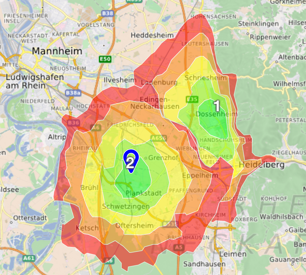
To this end we have been working on an updated OpenRouteService API to provide a richer feature set and more performant computations to deliver faster results for your needs. For example the new Isochrones API is used to determine reachability from given locations. With this is mind we have extended the interface and introduced the possibility to use a set of locations to find intersections of overlapping regions of accessibility.

ORS isochrones

ORS isochrones

Furthermore we are going to showcase OpenRouteService.org developed for catastrophes. This service has the exceptional ability to update itself within very short periods of time. We offer this due to regular updates of street networks by mapping parties or volunteers contributing critical information to OpenStreetMap.

Besides navigation services, we will also present two applications on further information extracted from OpenStreetMap. OSM Landuse Landcover is a WebGIS application to explore OpenStreetMap in terms of specific landuse and landcover information (LULC) classifications. HistOSM visually explores historic objects stored in the OpenStreetMap database. Your visual exploration process is supported by dynamically created statistics showing the top most used object categories in the current map view extent.
Since our services are based on user generated geo-data, we are highly involved in OSM data quality assessment e.g. based on the data’s history. To this end, we provide studies and services to analyze an improve OpenStreetMap data quality e.g. by investigating the data’s generation process or usage of deep learning.

We are more than happy to invite you to visit us at the Smart City Forum (hall 7) at the CeBIT convention in Hannover from the 20-24.03.2017. If you are interested in meeting us there, please let us know (openrouteservice@geog.uni-heidelberg.de) as we can provide you some free tickets.

HeiGIT is being established with core funding by the Klaus Tschira Foundation, Heidelberg.

Tags: Accessbility, API, Cebit, data quality, landuse, openrouteservice, OpenStreetMap, OSM, Services

Posted in Events, Press release

Comments are closed.

  • About

    GIScience News Blog
    News of Heidelberg University’s GIScience Research Group.
    There are 1,643 Posts and 0 Comments so far.

  • Meta

    • Log in
    • Entries RSS
    • Comments RSS
    • WordPress.org
  • Recent Posts

    • Social-Media-Daten für eine bessere Routenplanung freier Navigationsdienste
    • Understanding spatiotemporal trip purposes of urban micro-mobility from the lens of dockless e-scooter sharing
    • Audiobeitrag: Das Heidelberg Institute for Geoinformation Technology (HeiGIT) im Campus Radio
    • 3DGeo contributions to ISPRS Congress 2022 now online
    • Recent feature additions to Ohsome Quality analysT
  • Tags

    3D 3DGEO Big Spatial Data CAP4Access Citizen Science Climate Change Conference crisis mapping Crowdsourcing data quality deep learning disaster DisasterMapping GeoNet.MRN GIScience heigit HOT humanitarian humanitarian mapping Humanitarian OpenStreetMap team intrinsic quality analysis landuse laser scanning Lidar machine-learning Mapathon MapSwipe MissingMaps Missing Maps ohsome ohsome example Open data openrouteservice OpenStreetMap OSM OSM History Analytics Quality quality analysis remote sensing routing social media spatial analysis Teaching VGI Workshop
  • Archives

    • June 2022
    • May 2022
    • April 2022
    • March 2022
    • February 2022
    • January 2022
    • December 2021
    • November 2021
    • October 2021
    • September 2021
    • August 2021
    • July 2021
    • June 2021
    • May 2021
    • April 2021
    • March 2021
    • February 2021
    • January 2021
    • December 2020
    • November 2020
    • October 2020
    • September 2020
    • August 2020
    • July 2020
    • June 2020
    • May 2020
    • April 2020
    • March 2020
    • February 2020
    • January 2020
    • December 2019
    • November 2019
    • October 2019
    • September 2019
    • August 2019
    • July 2019
    • June 2019
    • May 2019
    • April 2019
    • March 2019
    • February 2019
    • January 2019
    • December 2018
    • November 2018
    • October 2018
    • September 2018
    • August 2018
    • July 2018
    • June 2018
    • May 2018
    • April 2018
    • March 2018
    • February 2018
    • January 2018
    • December 2017
    • November 2017
    • October 2017
    • September 2017
    • August 2017
    • July 2017
    • June 2017
    • May 2017
    • April 2017
    • March 2017
    • February 2017
    • January 2017
    • December 2016
    • November 2016
    • October 2016
    • September 2016
    • August 2016
    • July 2016
    • June 2016
    • May 2016
    • April 2016
    • March 2016
    • February 2016
    • January 2016
    • December 2015
    • November 2015
    • October 2015
    • September 2015
    • August 2015
    • July 2015
    • June 2015
    • May 2015
    • April 2015
    • March 2015
    • February 2015
    • January 2015
    • December 2014
    • November 2014
    • October 2014
    • September 2014
    • August 2014
    • July 2014
    • June 2014
    • May 2014
    • April 2014
    • March 2014
    • February 2014
    • January 2014
    • December 2013
    • November 2013
    • October 2013
    • September 2013
    • August 2013
    • July 2013
    • June 2013
    • May 2013
    • April 2013
  •  

    March 2017
    M T W T F S S
    « Feb   Apr »
     12345
    6789101112
    13141516171819
    20212223242526
    2728293031  
  • Recent Comments

    GIScience News Blog CC by-nc-sa Some Rights Reserved.

    Free WordPress Themes | Fresh WordPress Themes