
Recently HeiGIT @ GIScience Heidelberg released a dedicated stable disaster version of OpenRouteService (ORS) to support humanitarian logistics within specific regions of catastrophes with data from OSM in a more sustainable way. Since his start in 2008 OpenRouteServivce had been spontaneously applied for specific real world disaster cases already numerous times, for instance during the earthquakes in Haiti 2008 and 2010, in Nepal 2015, and in Equador 2016. Yet this always involved manual effort to set the system up for the specific disaster which costed time and manpower. For this reason this was only manageable for specific larger disasters. In order to provide this tool with most recent data to humanitarian organisations and affected people in a more stable, reliable and automated way, that covers also smaller disasters without manual intervention, the routing and disaster teams at HeiGIT jointly developed this new dedicated disaster ORS.
Basically the Disaster OpenRouteService is an adjusted version of the OpenRouteService which specifically serves the cause of routing considering specific meta information about passable ways from OpenStreetMap. It is constantly running on three individual and interchangeable regions in a distributed cloud environment. For the moment and first version these three permanently running instances cover Africa, South America and Indonesia.
The system has the exceptional ability to navigate on the most up-to-date OSM data added by disaster mappers as data and graph updates are currently computed daily for the whole regions covered. This allows to account for a high user activity and data adjustment rate in OSM during disaster situations, where both the real world situation, as well as the data in OSM are changing in very dynamic way. We are working on providing even more frequent update circles in the future in order to provide the best and most recent available OSM data to the disaster relief organisations, our partner the Humanitarian OpenStreetMap Team (HOT) and affected people as fast as possible in a fully automated manner.
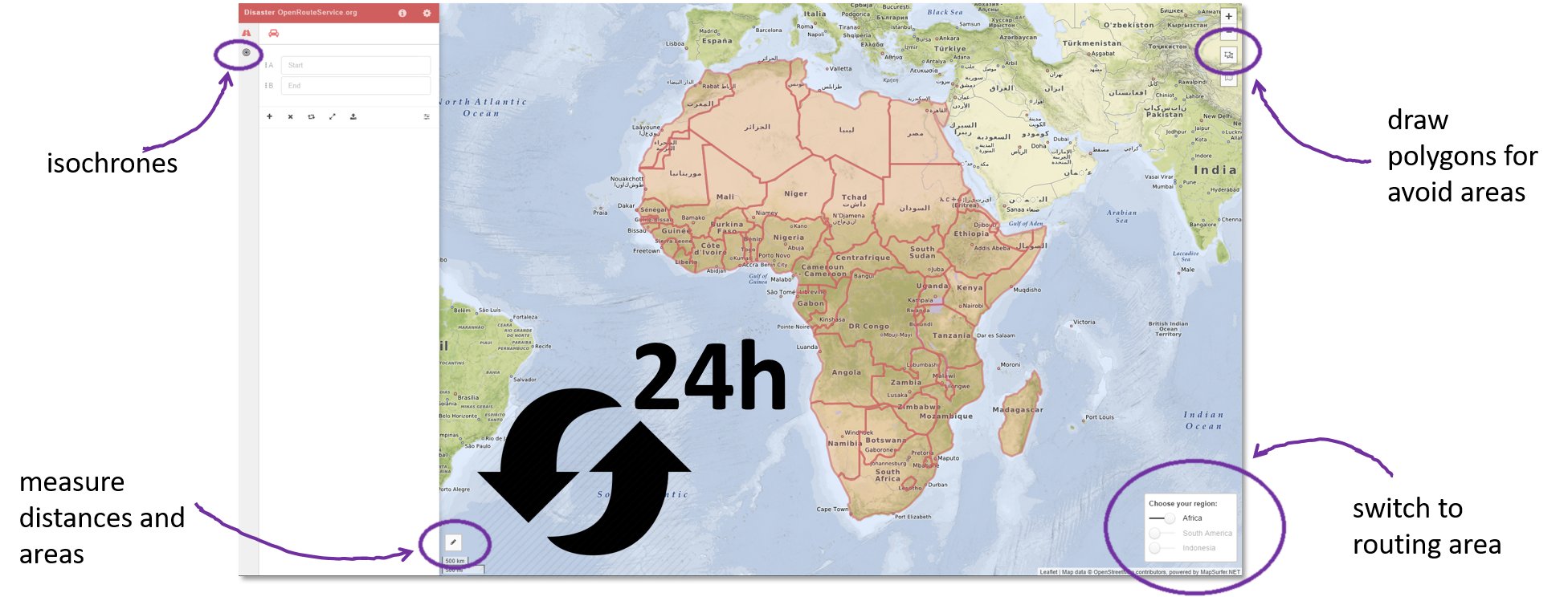
Moreover, similar to the conventional ORS the Disaster OpenRouteService also provides an accessibility analysis service (calculating fast isochrones) for a given location, the possibility to export GPS tracks to be used offline in mobile devices, and of course the interactive avoid area tool. The latter allows to interactively draw polygons into the map which mark severely affected, not accessible, or impassable regions or road sections which should be avoided for navigation, or are potentially valuable for Search and Rescue (SAR) units.
Similar to the OpenRouteService, the web application and the directions are already fully available in 7 languages, namely English, German, French, Spanish, Portuguese, Russian, and Chinese. Other languages, such as Greek, Hungarian, Italian, Dutch, Polish, Czech or Nepali are partially available as well (mostly directions on the backend side). In order to make the Disaster OpenRouteService applicable for disaster managers, first responders and affected people all around the world, please help us to update the translations and provide your language here.
In addition to the usage via the web application the API endpoint can be integrated in dedicated applications (e.g. QGIS Plugins) etc. Please contact us for further investigations. Stay tuned for future enhancements.
https://disaster.openrouteservice.org
We cordially do thank the Klaus Tschira Foundation, Heidelberg for the financial support and the Humanitarian OpenStreetMap Team for the helpful hints and insights, as well as the whole OSM community for their valuable efforts in generating relevant and up2date geographic data.
You can also follow us on Twitter and Facebook.