• Home
  • About

GIScience News Blog

News of Heidelberg University’s GIScience Research Group.

Feed on
Posts
Comments
« GIScience Colloquium talk on Semantic Signatures for Social Sensing in Smart Environments by Prof. Janowicz
OSMlanduse validation workshop »

Are Crowdsourced Datasets Suitable for Specialized Routing Services? Case Study of OpenStreetMap for Routing of People with Limited Mobility

Jun 28th, 2017 by GIScienceHD

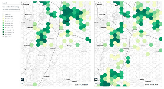
Using data generated from the crowd has become a hot topic for several application domains including transportation. However, there are concerns regarding the quality of such datasets. As one of the most important crowdsourced mapping platforms, in a recent study (1) we analyze the fitness for use of OpenStreetMap (OSM) database for routing and navigation of people with limited mobility. See (2) for background information. The completeness of OSM data is being assessed regarding sidewalk information. Relevant attributes for sidewalk information such as sidewalk width, incline, surface texture, etc. are considered, and through both extrinsic and intrinsic quality analysis methods (3), the results of fitness for use of OSM data for routing services of disabled persons are presented. Based on that empirical results, it is concluded that OSM data of relatively large spatial extents inside the studied cities could be an acceptable region of interest to test and evaluate wheelchair routing and navigation services, as long as other data quality parameters such as positional accuracy and logical consistency are checked and proved to be acceptable. We present an extended version of OSMatrix web service (4) and explore how it is employed to perform spatial and temporal analysis of sidewalk data completeness in OSM. The tool is beneficial for piloting activities, whereas the pilot site planners can query OpenStreetMap and visualize the degree of sidewalk data availability in a certain region of interest. This would allow identifying the areas that data are mostly missing and plan for data collection events. Furthermore, empirical results of data completeness for several OSM data indicators and their potential relation to sidewalk data completeness are presented and discussed.

(1) Mobasheri, A.; Sun, Y.; Loos, L.; Ali, A.L (2017): Are Crowdsourced Datasets Suitable for Specialized Routing Services? Case Study of OpenStreetMap for Routing of People with Limited Mobility. Sustainability 2017, 9(6), 997; doi:10.3390/su9060997

(2) Zipf, A.; Mobasheri, A.; Rousell, A.; Hahmann, S. (2016): Crowdsourcing for individual needs—The case of routing and navigation for mobility-impaired persons. In European Handbook of Crowdsourced Geographic Information; Capineri, C., Haklay, M., Huang, H., Antoniou, V., Kettunen, J., Ostermann, F., Puves, R., Eds.; Ubiquity Press: London, UK, 2016; pp. 325–337

(3) Barron, C., Neis, P. & Zipf, A. (2013): A Comprehensive Framework for Intrinsic OpenStreetMap Quality Analysis , Transactions in GIS, Volume 18, Issue 6, December 2014, Pages: 877–895 DOI: 10.1111/tgis.12073.

(4) Roick, O., Loos, L. & Zipf, A. (2012): Visualizing spatio-temporal quality metrics of Volunteered Geographic Information – A case study for OpenStreetMap. Geoinformatik 2012. Mobilität und Umwelt. Braunschweig. Germany.

OSM Wheelchair Routing for Europe at https://OpenRouteService.org
ORS with Open Spaces Pedrestrian Routing: https://Labs.OpenRouteService.org

OSMatrix for Europe: http://osmatrix.uni-hd.de

Tags: CAP4Access, openrouteservice, OSM, OSMatrix, Quality, quality analysis, Wheelchair Navigation

Posted in Publications

Comments are closed.

  • About

    GIScience News Blog
    News of Heidelberg University’s GIScience Research Group.
    There are 1,674 Posts and 0 Comments so far.

  • Meta

    • Log in
    • Entries RSS
    • Comments RSS
    • WordPress.org
  • Recent Posts

    • New paper on the automatic characterization of surface activities from 4D point clouds
    • OSHDB Version 1.0 Has Arrived
    • Job Opening for Postdoc / Senior Researcher on OpenStreetMap Road Quality Analysis
    • Geography Awareness Week 14.-19.11.2022
    • Open Data: Multi-platform point clouds and orthophotos of the inland dune in Sandhausen
  • Tags

    3D 3DGEO Big Spatial Data CAP4Access Citizen Science Conference crisis mapping Crowdsourcing data quality deep learning disaster DisasterMapping GeoNet.MRN GIScience heigit HOT humanitarian humanitarian mapping Humanitarian OpenStreetMap team intrinsic quality analysis landuse laser scanning Lidar machine-learning Mapathon MapSwipe MissingMaps Missing Maps ohsome ohsome example Open data openrouteservice OpenStreetMap OSM OSM History Analytics Public Health Quality quality analysis remote sensing routing social media spatial analysis Teaching VGI Workshop
  • Archives

    • December 2022
    • November 2022
    • October 2022
    • September 2022
    • August 2022
    • July 2022
    • June 2022
    • May 2022
    • April 2022
    • March 2022
    • February 2022
    • January 2022
    • December 2021
    • November 2021
    • October 2021
    • September 2021
    • August 2021
    • July 2021
    • June 2021
    • May 2021
    • April 2021
    • March 2021
    • February 2021
    • January 2021
    • December 2020
    • November 2020
    • October 2020
    • September 2020
    • August 2020
    • July 2020
    • June 2020
    • May 2020
    • April 2020
    • March 2020
    • February 2020
    • January 2020
    • December 2019
    • November 2019
    • October 2019
    • September 2019
    • August 2019
    • July 2019
    • June 2019
    • May 2019
    • April 2019
    • March 2019
    • February 2019
    • January 2019
    • December 2018
    • November 2018
    • October 2018
    • September 2018
    • August 2018
    • July 2018
    • June 2018
    • May 2018
    • April 2018
    • March 2018
    • February 2018
    • January 2018
    • December 2017
    • November 2017
    • October 2017
    • September 2017
    • August 2017
    • July 2017
    • June 2017
    • May 2017
    • April 2017
    • March 2017
    • February 2017
    • January 2017
    • December 2016
    • November 2016
    • October 2016
    • September 2016
    • August 2016
    • July 2016
    • June 2016
    • May 2016
    • April 2016
    • March 2016
    • February 2016
    • January 2016
    • December 2015
    • November 2015
    • October 2015
    • September 2015
    • August 2015
    • July 2015
    • June 2015
    • May 2015
    • April 2015
    • March 2015
    • February 2015
    • January 2015
    • December 2014
    • November 2014
    • October 2014
    • September 2014
    • August 2014
    • July 2014
    • June 2014
    • May 2014
    • April 2014
    • March 2014
    • February 2014
    • January 2014
    • December 2013
    • November 2013
    • October 2013
    • September 2013
    • August 2013
    • July 2013
    • June 2013
    • May 2013
    • April 2013
  •  

    June 2017
    M T W T F S S
    « May   Jul »
     1234
    567891011
    12131415161718
    19202122232425
    2627282930  
  • Recent Comments

    GIScience News Blog CC by-nc-sa Some Rights Reserved.

    Free WordPress Themes | Fresh WordPress Themes