
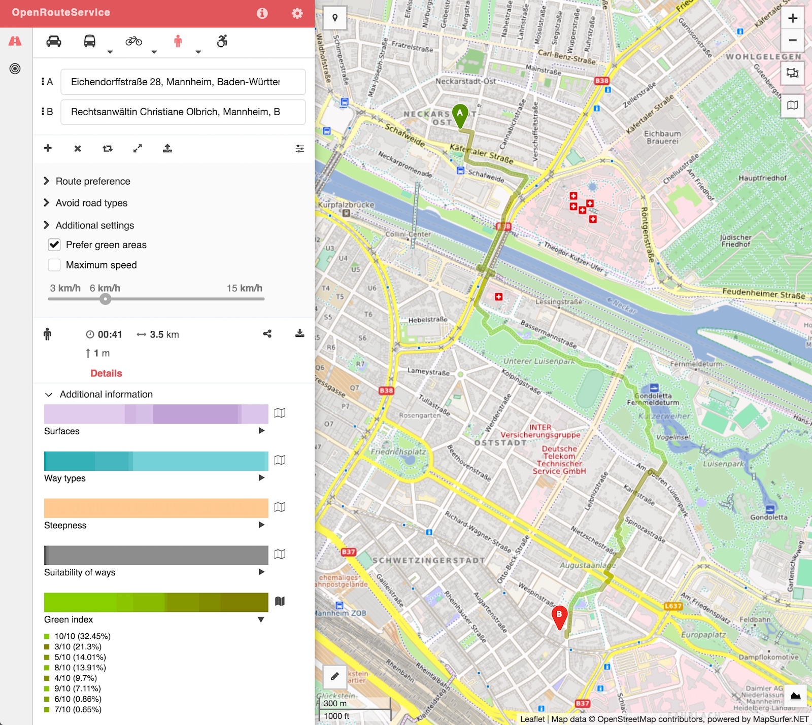
Research in psychology and public health shows that there are environmental factors that cause an area to impose more or less stress to a person. One example is that being surrounded by natural green areas (meadows, parks, trees and forests etc. or also blue water areas) has a relaxing influence to the mood of a person in contrast to walking through a highly urbanised non-natural area which broadly speaking puts more stress on someone. Therefore a route that may not be the shortest path, but one that prefers the existing of green land-use areas to some extend can be seen as the more stress-free and healthy choice.
If you want to plan such a more pleasant or healthy route, you now can activate the “prefer green areas” option in the “additional settings” section of pedestrian routing options of OpenRouteService.
For testing purposes this specific feature which is targeted towards urban areas is currently restricted to Germany only (similar to other experimental prototypes at the brand new labs.openrouteservice.org).
This feature is still experimental, as the results vary strongly with the calculation of the weights for the green score. The latter depends both on the way of preprocessing and algorithms, as well as the data completeness of the green area data in OpenStreetMap. So expect some interesting results sometimes. Yet, the first route computations look often quite reasonable and promising. But of course this is a subjective measure, as different people will prefer different settings and accept detours of different lengths in favour of a greener or more healthy route. So there is much need for further research and development. We will be working on giving the user the option to interactively change the weighting in a more dynamic and fine-grained manner than it is possible at the moment in order to truly personalise her tour.
The calculated green index has also been added to the enhanced visualisation options for the route segments on the Web client. This allows the user for different categories (like surfaces, way types, steepness, suitability and now also for the green index ) to interactively overlay for each route segment the specific values on the current route using adapted colour codings.
Enjoy testing this new features on OpenRouteService.org

This work was inspired and supported through our cooperation project on urban stress (Psychogeography) with the Psychoepidemiologisches Zentrum (PEZ) at the Central Institute for Mental Health (ZI Mannheim) and the Intelligent Mobility Group at HeiGIT. The latter is kindly supported by the Klaus Tschira Foundation, Heidelberg through the core-funding for HeiGIT (Heidelberg Institute for Geoinformation Technology). Follow up research can for example analyse the effects of the individual choices and preferences, also further attributes are under consideration.
Big thanks to the whole team for both preparing the landuse data (similar to OSMlanduse.org) based on OpenStreetMap and enhancing the routing service and client.