
In a newly published open access paper, we present a system that generates customized pedestrian routes entirely based on data from OpenStreetMap (OSM). The system enables users to define to what extent they would like the route to have green areas (e.g., parks, squares, trees), social places (e.g., cafes, restaurants, shops) and quieter streets (i.e., with less road traffic). We present how the greenness, sociability, and quietness factors are defined and extracted from OSM as well as how they are integrated into a routing cost function.
We intrinsically evaluate customized routes from one-thousand trips, i.e., origin–destination pairs, and observe that these are, in general, as we intended—slightly longer but significantly more social, greener, and quieter than the respective shortest routes. Based on a survey taken by 156 individuals, we also evaluate the system’s usefulness, usability, controlability, and transparency. The majority of the survey participants agree that the system is useful and easy to use and that it gives them the feeling of being in control regarding the extraction of routes in accordance with their greenness, sociability, and quietness preferences. The survey also provides valuable insights into users requirements and wishes regarding a tool for interactively generating customized pedestrian routes.
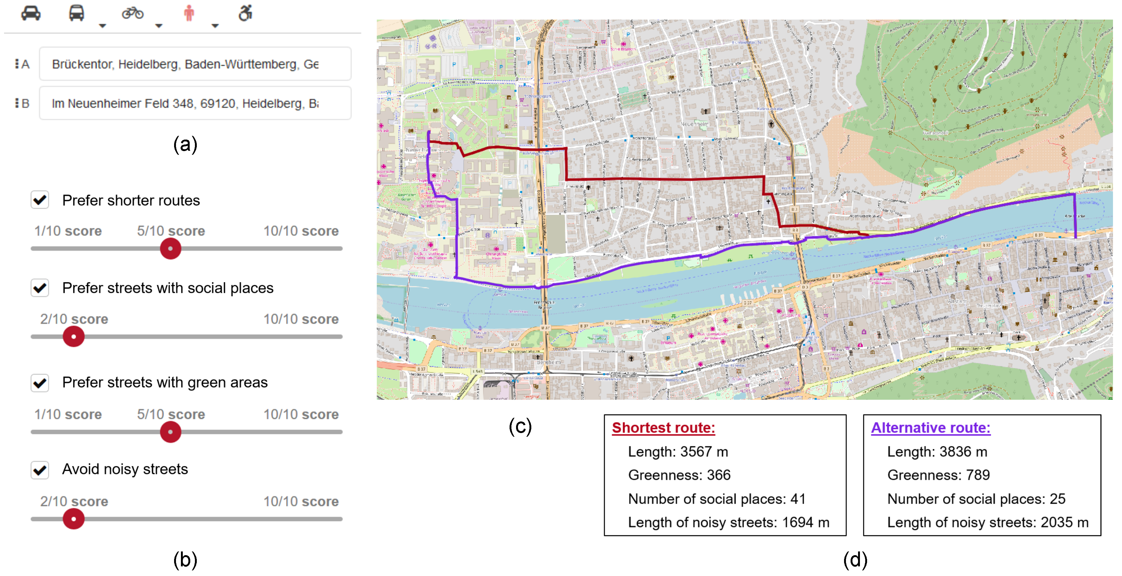
An important feature of the system is that it allows users to interactively define the weights of these factors in the extraction of the customized route. The system also informs users about the length, greenness, number of social places, and total length of noisy streets of the shortest and customized routes. This enables them to make a more aware decision on whether to take one of the two routes or to further edit the factor weights. In our opinion, such an user-system interaction is important to the extent that pedestrian route choice is subjective and dependent on the circumstances at the moment of the route request. We also presented the prototype of the system’s interface that is already integrated into OpenRouteService (ORS), a widely used open source web-service for several navigation purposes based on OSM data. ORS includes several research results, e.g. for the here explained healthy green & quiet routing, but also Landmark based navigation, routing across open spaces , wheelchair routing for all of Europe and more.
All this blends to earlier work and concepts on adaptive and personalized GI services (maps, routing, and navigation). While some ideas have already been developed in the late 90s and early 2000, due to the availability of VGI these ideas can now be brought into practice and evaluated scientifically.
New Publication:
Novack, T.; Wang, Z.; Zipf, A. (2018): A System for Generating Customized Pleasant Pedestrian Routes Based on OpenStreetMap Data. Sensors 2018, 18, 3794.
Related earlier publications:
- Zipf, A. & Röther, S. (2000): Tourenvorschläge für Stadttouristen mit dem ArcView Network Analyst. In: Liebig, W. (Hrsg.): ArcView Arbeitsbuch. Hüthig Verlag. Heidelberg.
- Zipf, A. & Aras, H. (2002): Proactive Exploitation of the Spatial Context in LBS – through Interoperable Integration of GIS-Services with a Multi Agent System (MAS). AGILE 2002. Int. Conf. on Geographic Information Science of the Association of Geographic Information Laboratories in Europe (AGILE). 04.2002. Palma. Spain.
- Zipf, A. (2002): User-Adaptive Maps for Location-Based Services (LBS) for Tourism. In: Woeber, K., Frew, A. & Hitz, M. (eds.), Proc. of the 9th Int. Conf. for Information and Communication Technologies in Tourism, ENTER 2002. Innsbruck, Austria. Springer Computer Science. Heidelberg, Berlin.
- Poslad, S., Laamanen, H., Malaka, R., Nick, A., Buckle, P. & Zipf, A. (2001): CRUMPET: Creation of User-Friendly Mobile Services Personalised for Tourism. Proceedings of: 3G 2001 – Second Int. Conf. on 3G Mobile Communication Technologies. 26-29.03.2001. London. UK.
- Zipf, A. (1998): DEEP MAP – A prototype context sensitive tourism information system for the city of Heidelberg. Proc. of GIS-Planet 98. Lisboa, Portugal.
- Neis, P. & Zipf, A (2008): OpenRouteService.org is three times “Open”: Combining OpenSource, OpenLS and OpenStreetMaps. GIS Research UK (GISRUK 08). Manchester.
- Miksch, J., Hahmann, S., Resch, B., Lauer, J., Zipf, A. (2017): Routing Through Open Spaces – A Performance Comparison Of Algorithms. Geo-Spatial information Science, 2017. Taylor & Francis. Geo-Spatial information Science, 2017. Taylor & Francis. https://doi.org/10.1080/10095020.2017.1399675
- Mobasheri A., Huang H., Degrossi L.C. and A. Zipf (2018): Enrichment of OpenStreetMap Data Completeness with Sidewalk Geometries Using Data Mining Techniques. Sensors 2018, 18(2), 509; doi:10.3390/s18020509
- Rousell A. and Zipf A. (2017): Towards a landmark based pedestrian navigation service using OSM data. International Journal of Geo-Information, ISPRS IJGI, 6(3): 64.
- Steiger, E., B. Resch, J. Porto de Albuquerque, A. Zipf (2016): Mining and correlating traffic events from human sensor observations with official transport data using self-organizing-maps. Transportation Research Part C: Emerging Technologies. Vol 73, Dec.16, pp 91–104. http://dx.doi.org/10.1016/j.trc.2016.10.010
- John, S., Hahmann, S., Rousell, A., Loewner, M., Zipf, A. (2016). Deriving incline values for street networks from voluntarily collected GPS traces. Cartography and Geographic Information Science (CaGIS). Taylor & Francis. DOI:10.1080/15230406.2016.1190300
- Reichert, M., Törnros, T., Hoell, A., Dorn, H., Tost, H., Salize, H.-J., Meyer-Lindenberg, A., Zipf, A., Ebner-Priemer, U. W. (2016). Using Ambulatory Assessment for experience sampling and the mapping of environmental risk factors in everyday life. Die Psychiatrie. 2/2016. 94-102. (pdf)
- Neis, P. & Zipf, A. (2008): Generating 3D Focus Maps for the (mobile) Web – an interoperable approach. International Journal of Location Based Services (JLBS). Vol. 2(2).
- Zipf, A & Jöst, M. (2005): Implementing Adaptive Mobile GI Services based on Ontologies – Examples for pedestrian navigation support. CEUS – Computers, Environment and Urban Systems – An International Journal. Special Issue on LBS and UbiGIS. Pegamon Press, Elsevier.
- Zipf, A. & Richter, K.F. (2002): Using Focus Maps to Ease Map Reading. Developing Smart Applications for Mobile Devices. Künstliche Intelligenz (KI) (Artificial Intelligence). Special Issue: Spatial Cognition. Vol.4, S.35-37.