• Home
  • About

GIScience News Blog

News of Heidelberg University’s GIScience Research Group.

Feed on
Posts
Comments
« GeOnG Conference 2018: Workshop Materials and Slides
A place for place, CFP for TGIS Special Issue on Modelling and Analysing Platial Representations »

How much do you know about Wheelmap?

Nov 12th, 2018 by m01

Within the European FP7 project “CAP4Access“, we studied the usage of crowdsourced geographic information (and more specifically OpenStreetMap data) for improving accessibility in selected European regions. This 3 year research study led to several implementations and extensions of Open Source GI solutions with respect to OSM data quality assessment as well as wheelchair routing and navigation. In previous blog posts we have already introduced the Wheelchair extension of OpenRouteService and also wrote about the navigation app for Openrouteservice.

Furthermore, during the piloting activities we organised several mapping events to use these apps in action and learn how they can be improved to provide better service. Wheelmap, an already existing platform developed by our project partner SozialHelden was also used and improved throughout this project.

One of the outcomes of the events was to learn from target groups that less people were aware of the availability of this software, especially young researchers who have the interest and knowledge to adapt it in their work and even further extend it. Therefore, together with colleagues at SozialHelden we present a software article entitled “Wheelmap: the wheelchair accessibility crowdsourcing platform” where you can find more technical details and information about how to use or extend this in your project. Wheelmap is an ongoing project. So, in case you are interested and have an idea on how to extend Wheelmap, kindly get in touch with the authors of this article for collaboration!
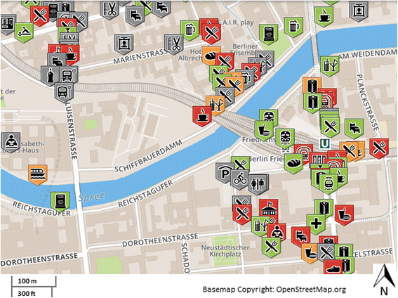
A map showing POIs in four different colours in Wheelmap

A map showing POIs in four different colours (accessibility levels) in Wheelmap

Further reading:

Mobasheri, A., Deister, J., Dieterich, H. (2017). Wheelmap: The Wheelchair Accessibility Crowdsourcing Platform . Journal of Open Geospatial Data, Software and Standards, 2: 27, doi: https://doi.org/10.1186/s40965-017-0040-5

Relevant Publications on this topic:

  • Mobasheri A., Huang H., Degrossi L.C. and A. Zipf (2018): Enrichment of OpenStreetMap Data Completeness with Sidewalk Geometries Using Data Mining Techniques. Sensors 2018, 18(2), 509; doi:10.3390/s18020509
  • Mobasheri, A. (2017). A rule-based spatial reasoning approach for OpenStreetMap Data quality enrichment; Case study of routing and navigation. Sensors, 17(11), 2498.
  • Zipf, A., Mobasheri, A., Rousell, A. ,Hahmann, S. (2016): Crowdsourcing for individual needs - the case of routing and navigation for mobility-impaired persons. In: Capineri, C, Haklay, M, Huang, H, Antoniou, V, Kettunen, J, Ostermann, F and Purves, R. (eds.) European Handbook of Crowdsourced Geographic Information, p. 325–337. London: Ubiquity Press. DOI: dx.doi.org/10.5334/bax.x
  • Rousell A. and Zipf A. (2017): Towards a landmark based pedestrian navigation service using OSM data. International Journal of Geo-Information, ISPRS IJGI, 6(3): 64.
  • Miksch, J., Hahmann, S., Resch, B., Lauer, J., Zipf, A. (2017): Routing Through Open Spaces - A Performance Comparison Of Algorithms. Geo-Spatial information Science, 2017. Taylor & Francis. Geo-Spatial information Science, 2017. Taylor & Francis. https://doi.org/10.1080/10095020.2017.1399675
  • John, S., Hahmann, S., Rousell, A., Loewner, M., Zipf, A. (2016). Deriving incline values for street networks from voluntarily collected GPS traces. Cartography and Geographic Information Science (CaGIS). Taylor & Francis. DOI:10.1080/15230406.2016.1190300
  • Neis, P. & Zipf, A (2008): OpenRouteService.org is three times “Open”: Combining OpenSource, OpenLS and OpenStreetMaps. GIS Research UK (GISRUK 08). Manchester.
  • Novack, T., Wang, Z., Zipf, A. (2018): A System for Generating Customized Pleasant Pedestrian Routes Based on OpenStreetMap Data. Sensors 2018, 18, 3794. https://doi.org/10.3390/s18113794
  • Müller, A., Neis, P. & Zipf, A. (2010): Ein Routenplaner für Rollstuhlfahrer auf der Basis von OpenStreetMap-Daten. Konzeption, Realisierung und Perspektiven. AGIT 2010. Symposium für Angewandte Geoinformatik. Salzburg. Austria.

Tags: Accessibility, CAP4Access, MyAccessible.EU, OpenRouteService, OpenStreetMap, OSM, routing, wheelchair, Wheelchair Navigation, WheelMap

Posted in External Projects, OSM, Publications, Research, VGI Group

Comments are closed.

  • About

    GIScience News Blog
    News of Heidelberg University’s GIScience Research Group.
    There are 1,138 Posts and 11 Comments so far.

  • Meta

    • Log in
    • Entries RSS
    • Comments RSS
    • WordPress.org
  • Recent Posts

    • Lukas Winiwarter wins Karl Kraus Award 2019
    • Publication of multi-sensor data from Arctic Siberian permafrost site
    • HeiGIT and Humanitarian OpenStreetMap Team at the Geospatial World Forum 2019 in Amsterdam
    • Mapping ecosystem services – the example of crop pollination
    • Using Openrouteservice in the data science platform alteryx
  • Tags

    3D AGILE Big Spatial Data CAP4Access Citizen Science Colloquium crisis mapping Crowd Analyser Crowdsourcing data quality disaster DisasterMapping GeoNet.MRN GIScience heigit humanitarian Humanitarian OpenStreetMap team intrinsic quality analysis landuse laser scanning Lidar Mapathon MapSwipe Missing Maps MissingMaps ohsome Open data OpenRouteService OpenStreetMap OSM OSM History Analytics OSMlanduse Quality quality analysis remote sensing routing social media spatial analysis Teaching Twitter VGI WebGIS wheelchair Wheelchair Navigation Workshop
  • Archives

    • February 2019
    • January 2019
    • December 2018
    • November 2018
    • October 2018
    • September 2018
    • August 2018
    • July 2018
    • June 2018
    • May 2018
    • April 2018
    • March 2018
    • February 2018
    • January 2018
    • December 2017
    • November 2017
    • October 2017
    • September 2017
    • August 2017
    • July 2017
    • June 2017
    • May 2017
    • April 2017
    • March 2017
    • February 2017
    • January 2017
    • December 2016
    • November 2016
    • October 2016
    • September 2016
    • August 2016
    • July 2016
    • June 2016
    • May 2016
    • April 2016
    • March 2016
    • February 2016
    • January 2016
    • December 2015
    • November 2015
    • October 2015
    • September 2015
    • August 2015
    • July 2015
    • June 2015
    • May 2015
    • April 2015
    • March 2015
    • February 2015
    • January 2015
    • December 2014
    • November 2014
    • October 2014
    • September 2014
    • August 2014
    • July 2014
    • June 2014
    • May 2014
    • April 2014
    • March 2014
    • February 2014
    • January 2014
    • December 2013
    • November 2013
    • October 2013
    • September 2013
    • August 2013
    • July 2013
    • June 2013
    • May 2013
    • April 2013
  •  

    November 2018
    M T W T F S S
    « Oct   Dec »
     1234
    567891011
    12131415161718
    19202122232425
    2627282930  
  • Recent Comments

    • Wilford on High Cartographic Quality Label Placement on OSM-based Map
    • Quyen on High Cartographic Quality Label Placement on OSM-based Map
    • Hier on Long-expected major Update on OpenRouteService with many new features in backend and frontend
    • forum on OpenStreetMap and Mapsurfer.NET help to search for missing people
    • nedir on Long-expected major Update on OpenRouteService with many new features in backend and frontend

GIScience News Blog CC by-nc-sa Some Rights Reserved.

Free WordPress Themes | Fresh WordPress Themes