• Home
  • About

GIScience News Blog

News of Heidelberg University’s GIScience Research Group.

Feed on
Posts
Comments
« QGIS Plugin OSM Tools v3.2 published
Deadline extended to 08.12.2018 for Full Papers for the International Conference on Information Systems for Crisis Response and Management (ISCRAM), Valencia »

New OpenRouteService API playground

Nov 28th, 2018 by Amon Santana

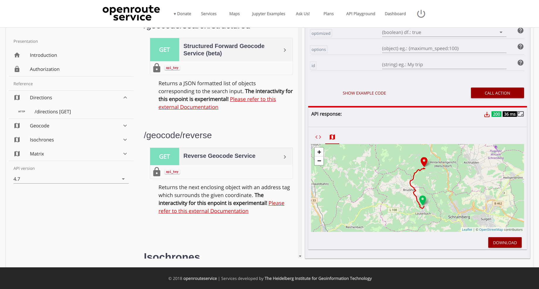
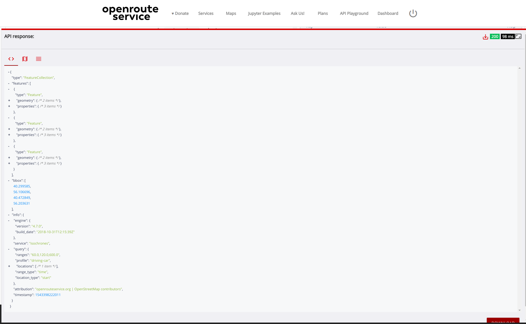
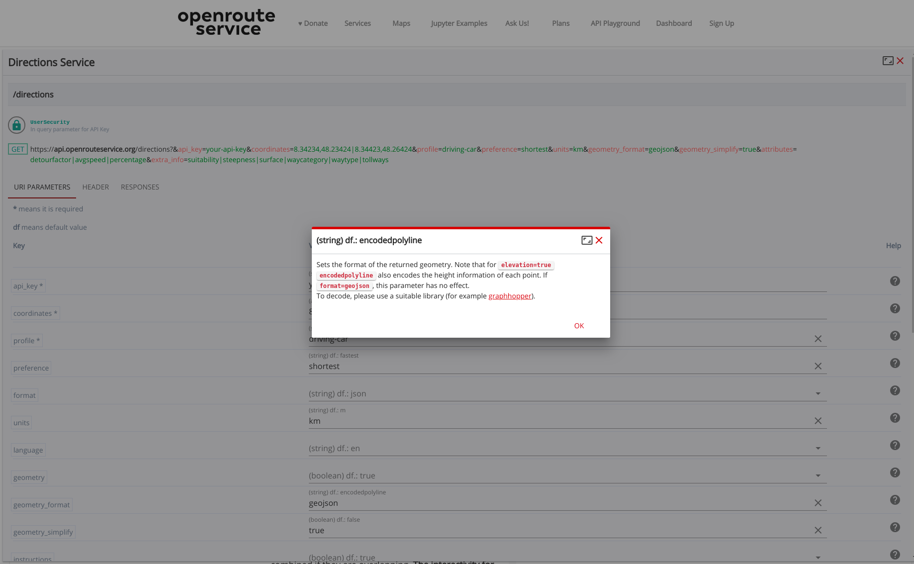
After the release of the new OpenRouteService dashboard the team has worked on a new interactive API documentation application named API Playground , that allows the users to explore all the OpenRouteService API services, parameters and responses in an intuitive and easy way. It is possible run requests, see the response in a map, table or navigable JSON document, according the response type, or even download the response.


Directions request result

Directions request result

The API Playground is fully integrated with the new ORS Dashboard so that once the user is authenticated the valid API token linked to the account is automatically loaded in the request forms.

A first key aspect of the API Playground Web App is that it is actually a dynamic API documentation parser and builder. The elements of the interactive documentation are built based on an OpenRouteService API documentation file. The app can also handle multiple versions of API documentations so that when a new API version is released it is available to be selected by the user, being possible to explore the playground and easily switch between versions.

Notwithstanding the fact of having the API resources, endpoints and forms being dynamically built the app was designed to deliver also an intuitive and responsive interface, keeping the polished look and feel found in the dashboard. To achieve this solution we have created new modules to our single page application using the Vue.js framework and Leaflet.

JSON response view maximized

JSON response view maximized

A second important aspect is that the API Playground is completely responsive and adapts its elements according the available resolution, cascading the columns and navigable elements based on available space.  In addition it was created also a custom box component that allows the users to “maximize/minimize” sections of the Web App so that the user can focus on what is important for a given interaction.

Directions form maximized with param help open

Directions form maximized with param help open

What is new?
  • New interactive documentation web app.
  • Integration with the dashboard to load user’s token key
  • Results in table, JSON, GPX or map
  • Navigable json response display
  • Download the response as a JSON document
  • Code samples updated on the fly for different languages
  • Map component with support to display routes, places/points and isochrones
  • Support for Makdown describing fields’ help and responses
  • Beautified code, GPX, JSON and code inside markdown documents
  • Selectable/restricted parameters input avoiding providing wrong values
  • Parameter input fields and help accessible in in the same view
  • Maximizable form, help, map and other responses results view
  • Colorized URL, param and values, making it easier to distinguish them
  • Single click to copy action URL
  • Response time for each request
  • Explore multiple versions of the API
API Playground:
https://openrouteservice.org/dev/#/api-docs
OpenRouteService:
https://openrouteservice.org

Tags: API, geocoder, isochrones, openrouteservice, OpenStreetMap, ORS, Playground, routing

Posted in Services, Software

Comments are closed.

  • About

    GIScience News Blog
    News of Heidelberg University’s GIScience Research Group.
    There are 1,679 Posts and 0 Comments so far.

  • Meta

    • Log in
    • Entries RSS
    • Comments RSS
    • WordPress.org
  • Recent Posts

    • High Resolution Data Insights from OpenStreetMap Element Vectorisation
    • Data publication: Point clouds of snow-on and snow-off forest site
    • Job Offer: Deep Learning Engineer (m/f/d, up to 100%)
    • GIScience Postdoc/Senior Researcher Opportunity for OpenStreetMap Road Quality Analysis
    • Assessing road criticality and loss of healthcare accessibility during floods: the case of Cyclone Idai, Mozambique 2019
  • Tags

    3D 3DGEO Big Spatial Data CAP4Access Citizen Science Conference crisis mapping Crowdsourcing data quality deep learning disaster DisasterMapping GeoNet.MRN GIScience heigit HOT humanitarian humanitarian mapping Humanitarian OpenStreetMap team intrinsic quality analysis landuse laser scanning Lidar machine-learning Mapathon MapSwipe MissingMaps Missing Maps ohsome ohsome example Open data openrouteservice OpenStreetMap OSM OSM History Analytics Public Health Quality quality analysis remote sensing routing social media spatial analysis Teaching VGI Workshop
  • Archives

    • February 2023
    • January 2023
    • December 2022
    • November 2022
    • October 2022
    • September 2022
    • August 2022
    • July 2022
    • June 2022
    • May 2022
    • April 2022
    • March 2022
    • February 2022
    • January 2022
    • December 2021
    • November 2021
    • October 2021
    • September 2021
    • August 2021
    • July 2021
    • June 2021
    • May 2021
    • April 2021
    • March 2021
    • February 2021
    • January 2021
    • December 2020
    • November 2020
    • October 2020
    • September 2020
    • August 2020
    • July 2020
    • June 2020
    • May 2020
    • April 2020
    • March 2020
    • February 2020
    • January 2020
    • December 2019
    • November 2019
    • October 2019
    • September 2019
    • August 2019
    • July 2019
    • June 2019
    • May 2019
    • April 2019
    • March 2019
    • February 2019
    • January 2019
    • December 2018
    • November 2018
    • October 2018
    • September 2018
    • August 2018
    • July 2018
    • June 2018
    • May 2018
    • April 2018
    • March 2018
    • February 2018
    • January 2018
    • December 2017
    • November 2017
    • October 2017
    • September 2017
    • August 2017
    • July 2017
    • June 2017
    • May 2017
    • April 2017
    • March 2017
    • February 2017
    • January 2017
    • December 2016
    • November 2016
    • October 2016
    • September 2016
    • August 2016
    • July 2016
    • June 2016
    • May 2016
    • April 2016
    • March 2016
    • February 2016
    • January 2016
    • December 2015
    • November 2015
    • October 2015
    • September 2015
    • August 2015
    • July 2015
    • June 2015
    • May 2015
    • April 2015
    • March 2015
    • February 2015
    • January 2015
    • December 2014
    • November 2014
    • October 2014
    • September 2014
    • August 2014
    • July 2014
    • June 2014
    • May 2014
    • April 2014
    • March 2014
    • February 2014
    • January 2014
    • December 2013
    • November 2013
    • October 2013
    • September 2013
    • August 2013
    • July 2013
    • June 2013
    • May 2013
    • April 2013
  •  

    November 2018
    M T W T F S S
    « Oct   Dec »
     1234
    567891011
    12131415161718
    19202122232425
    2627282930  
  • Recent Comments

    GIScience News Blog CC by-nc-sa Some Rights Reserved.

    Free WordPress Themes | Fresh WordPress Themes