
Todays data production, maintenance, and use have changed in the last years. While these tasks were reserved to professionals until a few years ago, the situation has changed. This is no different in the geographical domain. Volunteers gather general information in Wikipedia and geographical information in OpenStreetMap. Twitter users provide not only text snippets but in some cases also their current coordinates. Whenever people interact in the production, maintenance, or use, they become part of a social process, leading to a new form of data sources. Many terms used in this context (VGI, UGC, etc.) have some connotation by the way the are used. Our journal article ‘Shared Data Sources in the Geographical Domain’ examines such social data sources in general without restricting to a certain domain.
We coin the term ‘Shared Data Sources’ as a generic umbrella term without any connotation that is often inherent to other terms: ‘A dataset or project is called a “Shared Data Source” (SDS) if its production, maintenance, and use are predominantly social processes.’ In addition, ‘we coin the term “Geographical Shared Data Sources” (GSDS) for referring to Shared Data Sources in the geographical domain.’ Feel free to do use these terms when referring to all these datasets. Contributors and users share these datasets in various ways, they have become social!
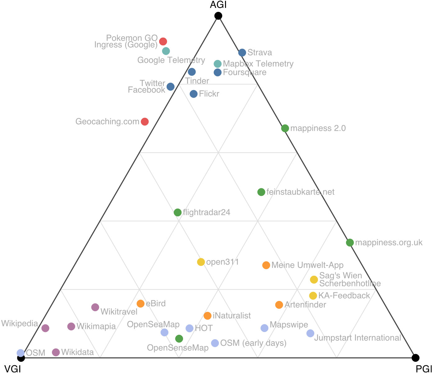
Existing Shared Data Sources are often discussed in the context of Volunteered Geographic Information (VGI), Ambient Geographic Information (AGI), and Participatory Geographic Information (PGI). We use these (proto)types to set Shared Data Sources in their mutual context. The Triangle of Shared Data Sources (see above) is only one such example. Our journal article contains some more such visualizations.
Mocnik, F.-B., Ludwig, C., Grinberger, A.Y., Jacobs, C., Klonner, C., Raifer, M. (2019): Shared Data Sources in the Geographical Domain—A Classification Schema and Corresponding Visualization Techniques ISPRS International Journal of Geo-Information 8(5), 242.
Related articles:
Mocnik, F.-B., Zipf, A., Raifer, M. (2017): The OpenStreetMap Folksonomy and Its Evolution. Geo-spatial Information Science 20(3), 219–230.
Mocnik, F.-B., Mobasheri, A., Griesbaum, L., Eckle, M., Jacobs, C., Klonner, C. (2018): A Grounding-Based Ontology of Data Quality Measures. Journal of Spatial Information Science 16, 1-25.
Mocnik, F.-B., Mobasheri, A., Zipf, A. (2018): Open Source Data Mining Infrastructure for Exploring and Analysing OpenStreetMap. Open Geospatial Data, Software and Standards 3(7).