Namibia is a dry and low populated country highly dependent on agriculture, with many areas experiencing land degradation accelerated by climate change. One of the most obvious and damaging manifestations of these degradation processes are gullies, which lead to great economic losses while accelerating desertification.
The development of standardized methods to detect and monitor the evolution of gully-affected areas is crucial to plan prevention and remediation strategies.
This paper explores fully automated satellite-based remote sensing methods with the aim of developing solutions applicable at a regional or even national scale. For this purpose, three different algorithms are applied to a Digital Elevation Model (DEM) generated from the TanDEM-X satellite mission to extract gullies from their geomorphological characteristics: (i) Inverted Morphological Reconstruction (IMR), (ii) Smoothing Moving Polynomial Fitting (SMPF) and (iii) Multi Profile Curvature Analysis (MPCA). These algorithms are adapted or newly developed to identify gullies at the pixel level (12 m) in our study site in the Krumhuk Farm. The results of the three methods are benchmarked with ground truth; specific scenarios are observed to better understand the performance of each method.
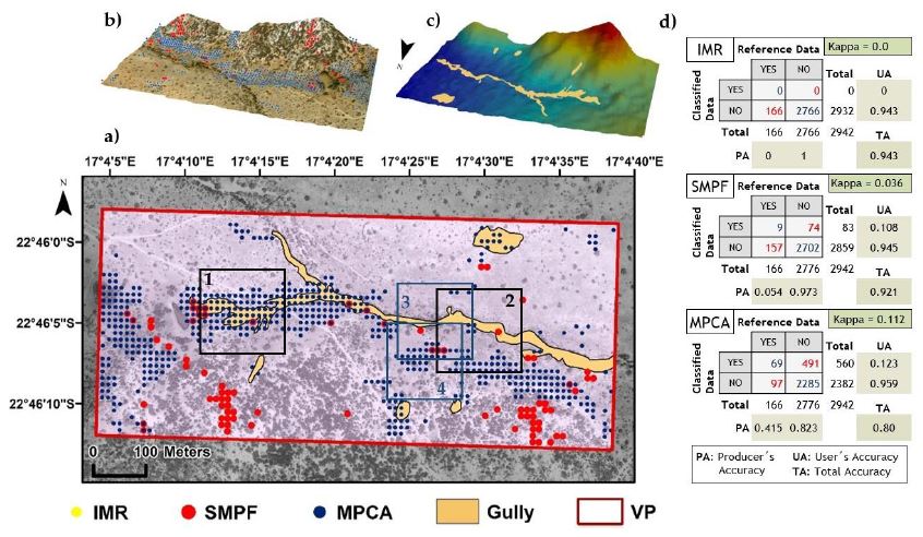
Results show that MPCA is the most reliable method to identify gullies, achieving an overall accuracy of ca. 0.80 with values of Cohen Kappa close to 0.35. The performance of these parameters improves when detecting large gullies (>30 m width and >3 m depth) achieving Total Accuracies (TA) near to 0.90, Cohen Kappa above 0.5, and User Accuracy (UA) and Producer Accuracy (PA) over 0.50 for the gully class. Small gullies (<12 m wide and <2 m deep) are usually neglected in the classification results due to spatial resolution constraints within the input DEM. In addition, IMR generates accurate results for UA in the gully class (0.94).
The MPCA method developed here is a promising tool for the identification of large gullies considering extensive study areas. Nevertheless, further development is needed to improve the accuracy of the algorithms, as well as to derive geomorphological gully parameters (e.g., perimeter and volume) instead of pixel-level classification.
Find all details in the full paper:
- Orti, M.V., Negussie, K., Corral-Pazos-de-Provens, E., Höfle, B. & Bubenzer, O. (2019): Comparison of Three Algorithms for the Evaluation of TanDEM-X Data for Gully Detection in Krumhuk Farm (Namibia). Remote Sensing. Vol. 11 (11), pp. 1-22.