
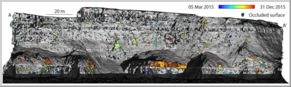
Rockfalls commonly exhibit power law volume-frequency distributions, where fewer large events are observed relative to more numerous small events. Within most inventories, the smallest rockfalls are the most difficult to detect and so may not be adequately represented. A primary challenge occurs when neighboring events within a single monitoring interval are recorded as one, producing ambiguity in event location, timing, volume, and frequency. Identifying measurement intervals that minimize these uncertainties is therefore essential. To address this, we use an hourly dataset comprising 8,987 3D point clouds of a cliff that experiences frequent rockfalls. Multiple rockfall inventories are derived from this dataset using change detections for the same 10-month period, but over different monitoring intervals. The power law describing the probability distribution of rockfall volumes is highly sensitive to monitoring interval. The exponent, β,is stable for intervals >12h but increases nonlinearly over progressively short timescales. This change is manifested as an increase in observed rockfall numbers, from 1.4×10³ (30 d intervals) to 1.4×10⁴ (1 h intervals), and a threefold reduction in mean rockfall volume. When the monitoring interval exceeds 4 h, the geometry of detected rockfalls becomes increasingly similar to that of blocks defined by rock mass structure. This behavior change reveals a time-dependent component to rockfall occurrence, where smaller rockfalls (identifiable from more frequent monitoring) are more sensitive to progressive deformation of the rock mass. Acquiring complete inventories and attributing discrete controls over rockfall occurrence may therefore only be achievable with high-frequency monitoring, dependent upon local lithology.
Find all details in the full paper:
Williams, J.G., Rosser, N.J., Hardy, R.J. & Brain, M.J. (2019) The Importance of Monitoring Interval for Rockfall Magnitude‐Frequency Estimation. Journal of Geophysical Research: Earth Surface, DOI: https://doi.org/10.1029/2019JF005225.
The results of this research were derived using methods for change detection near-continuous terrestrial LiDAR monitoirng outlined in Williams et al. (2018):
Williams, J.G., Rosser, N.J., Hardy, R.J., Brain, M.J. & Afana, A.A. (2018): Optimising 4-D surface change detection: an approach for capturing rockfall magnitude–frequency. Earth surface dynamics., 6(1), pp.101-119. DOI: https://doi.org/10.5194/esurf-6-101-2018.