On November 12-13, Jannika Schäfer from KIT presented the SYSSIFOSS project at the 2nd symposium on satellite-based earth obersvation (2. Symposium zur angewandten Satellitenerdbeoachtung) in Cologne.
SYSSIFOSS is a joint project between the Institute of Geography and Geoecology (IFGG) of the Karlsruhe Institute of Technology (KIT) and the 3DGeo Research Group of Heidelberg University.
In this project a new approach to create synthetic LiDAR data is suggested by combining the outputs of an established forest growth simulator with a to-be-created database of species-specific model trees extracted from real LiDAR point clouds. This approach will result in inventory information at the single tree level and a matching 3D forest structure for large areas.
The presented poster can be found here:
Schäfer, J., Faßnacht, F., Höfle, B. & Weiser, H.(2019): Das SYSSIFOSS-Projekt: Synthetische 3D-Fernerkundungsdaten für verbesserte Waldinventurmodelle. In: 2. Symposium zur angewandten Satellitenerdbeoachtung, Cologne, Germany, pp.1-1.
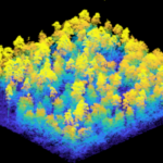
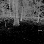
After a busy summer of data acquisition (UAV-borne and terrestrial laser scanning, field inventories), the team is now working on combining the different data sources, segmenting individual trees, exctracting tree parameters and generating tree models for virtual scanning. Moreover, a database of species-specific model trees will be set up. Find some first impressions of the acquired data below.
Find more details on the SYSSIFOSS project on the project website and in recent blog posts.
The project is funded by the Deutsche Forschungsgemeinschaft (DFG, German Research Foundation) – Project number: 411263134.