
New paper on “Multitemporal Terrestrial Laser Scanning Point Clouds for Thaw Subsidence Observation at Arctic Permafrost Monitoring Sites”
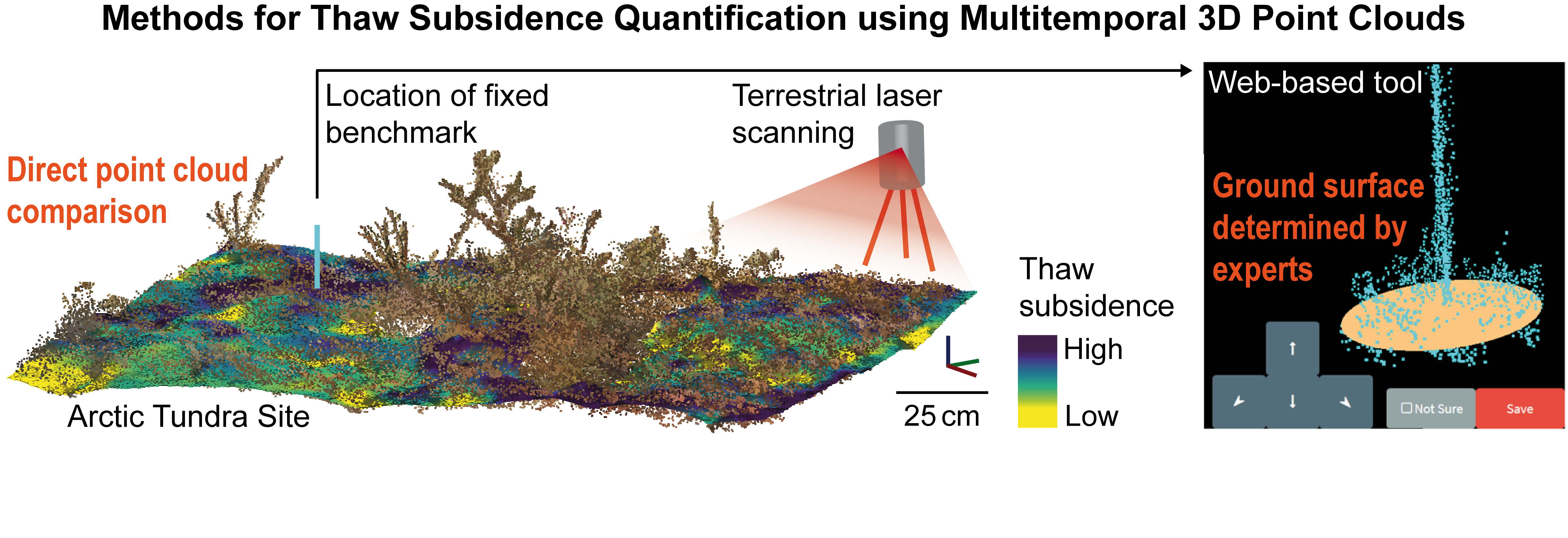
The paper investigates different methods for quantifying thaw subsidence using terrestrial laser scanning (TLS) point clouds. Thaw subsidence is a slow (mm‐cm per year) vertical displacement of the ground surface common in ice‐rich permafrost‐underlain landscapes. It is difficult to quantify thaw subsidence in tundra areas as they often lack stable reference frames. Also, there is no solid ground surface to serve as a basis for elevation measurements, due to a continuous moss‐lichen cover. We investigate how an expert‐driven method improves the accuracy of benchmark measurements at discrete locations within two sites using multitemporal TLS data of a one‐year period. Our method aggregates multiple experts’ determination of the ground surface in 3D point clouds, collected in a web‐based tool. We then compare this to the performance of a fully automated ground surface determination method. Lastly, we quantify ground surface displacement by directly computing multitemporal point cloud distances, thereby extending thaw subsidence observation to an area-based assessment. Using the expert-driven quantification as reference, we validate the other methods, including in-situ benchmark measurements from a conventional field survey. This study demonstrates that quantifying the ground surface using 3D point clouds is more accurate than the field survey method. The developed methods enable a link of automated quantification and expert judgment for transparent long‐term monitoring of permafrost subsidence.
Read the full paper with open access:
, , , , , , , and (2020): Multitemporal Terrestrial Laser Scanning Point Clouds for Thaw Subsidence Observation at Arctic Permafrost Monitoring Sites. Earth Surf. Process. Landforms, DOI: https://doi.org/10.1002/esp.4833.
The source code and data of the web-based tool can be downloaded here:
Herfort, B., Anders, K., Marx, S., Eberlein, S., Höfle, B. (2020): 3D Micro-Mapping of Subsidence Stations [Source Code and Data], heiDATA, V1, DOI: https://doi.org/10.11588/data/OU8YA1.
Also, the data used in this research are openly available:
Anders, K., Antonova, S., Beck, I., Boike, J., Höfle, B., Langer, M., Marsh, P., Marx, S., (2018): Multisensor ground-based measurements of the permafrost thaw subsidence in the Trail Valley Creek, NWT, Canada, 2015-2016. Alfred Wegener Institute, Helmholtz Center for Polar and Marine Research, Bremerhaven, PANGAEA, DOI: 10.1594/PANGAEA.888566.
This research was conducted in the frame of the PermaSAR project, which was a cooperation of the Permafrost Research Unit (Alfred Wegener Institute) and the 3DGeo Research Group (Heidelberg University) and funded by the BMWi/DLR in the framework “Entwicklung von innovativen wissenschaftlichen Methoden und Produkten im Rahmen der TanDEM-X Science Phase”.