• Home
  • About

GIScience News Blog

News of Heidelberg University’s GIScience Research Group.

Feed on
Posts
Comments
« Hitzebelastung in der Heidelberger Bahnstadt - Interview mit Kathrin Foshag
Inferencing indoor room semantics using random forest and relational graph convolutional networks (deep learning) »

OSM Missing Areas Identification paper is featured in August by ISPRS Journal of Photogrammetry and Remote Sensing

Aug 17th, 2020 by GIScienceHD

We are pleased that our article has been selected by the editors of ISPRS Journal of Photogrammetry and Remote Sensing as the featured Article in August 2020.
This means it will be available open access for 1 year. Get your copy here and enjoy a nice summer reading:

Li, H., B. Herfort, W. Huang, M. Zia, A. Zipf (2020): Exploration of OpenStreetMap missing built-up areas using twitter hierarchical clustering and deep learning in Mozambique Vol. 166, Pages 41-51 https://doi.org/10.1016/j.isprsjprs.2020.05.007

Accurate and detailed geographical information digitizing human activity patterns plays an essential role in response to natural disasters. Volunteered geographical information, in particular OpenStreetMap (OSM), shows great potential in providing the knowledge of human settlements to support humanitarian aid, while often the availability and quality of OSM remains a major concern. The majority of existing research in assessing OSM data quality focus on either extrinsic or intrinsic analysis, which is insufficient to fulfill the humanitarian mapping scenario to a certain degree. A recently accepted paper aims to explore missing built-up areas in OSM from a perspective integrating social sensing and remote sensing.
A new workflow has been developed to estimate and map those missing residential areas in OSM:

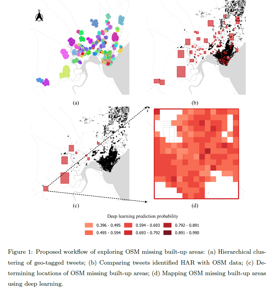
  • First, applying hierarchical DBSCAN clustering algorithm, the clusters of geo-tagged tweets are generated as proxies of human active regions.
  • Then a deep learning based model fine-tuned on existing OSM data is proposed to further map the missing built-up areas.

Hit by Cyclone Idai and Kenneth in 2019, the Republic of Mozambique is selected as the study area to evaluate the proposed method at a national scale. As a result, 13 OSM missing built-up areas have beend identified in that region. They have been mapped with an over 90% overall accuracy. This is competitive compared to state-of-the-art products, which confirms the effectiveness of the proposed method.

Previous related work, e.g.:

  • Herfort, B., Li, H., Fendrich, S., Lautenbach, S., Zipf, A. (2019): Mapping Human Settlements with Higher Accuracy and Less Volunteer Efforts by Combining Crowdsourcing and Deep Learning. Remote Sensing 11(15), 1799. https://doi.org/10.3390/rs11151799
  • Li, H., Herfort, B., Zipf, A. (2019): Estimating OpenStreetMap Missing Built-up Areas using Pre-trained Deep Neural Networks. 22nd AGILE Conference on Geographic Information Science, Limassol, Cyprus.
  • Chen, J., Y. Zhou, A. Zipf and H. Fan (2018): Deep Learning from Multiple Crowds: A Case Study of Humanitarian Mapping. IEEE Transactions on Geoscience and Remote Sensing (TGRS). 1-10. https://doi.org/10.1109/TGRS.2018.2868748

General Overview:

  • Yan, Y., C. Feng, W. Huang, H. Fan, Y. Wang & A. Zipf (2020): Volunteered geographic information research in the first decade: a narrative review of selected journal articles in GIScience. International Journal of Geographical Information Science, DOI: 10.1080/13658816.2020.1730848
  • Degrossi L.C., J. Porto de Albuquerque, R. dos Santos Rocha, A. Zipf (2018): A taxonomy of quality assessment methods for volunteered and crowdsourced geographic information. Transactions in GIS (TGIS). Wiley. DOI:10.1111/tgis.12329.
  • Jokar Arsanjani, J., Zipf, A., Mooney, P., Helbich, M. (Eds.)(2015): OpenStreetMap in GIScience: Experiences, Research, and Applications. Series: Lecture Notes in Geoinformation and Cartography. 2015, VII, 373 p. Sringer Science. Heidelberg, Berlin. ISBN 978-3-319-14279-1
  • Scholz, S., Knight, P., Eckle, M., Marx, S., Zipf, A. (2018): Volunteered Geographic Information for Disaster Risk Reduction: The Missing Maps Approach and Its Potential within the Red Cross and Red Crescent Movement. Remote Sensing, 10(8), 1239, doi: 10.3390/rs10081239.

Tags: clustering, deep learning, deep neural networks, Missing Maps, OSM, Twitter

Posted in Events, Publications

Comments are closed.

  • About

    GIScience News Blog
    News of Heidelberg University’s GIScience Research Group.
    There are 1,484 Posts and 0 Comments so far.

  • Meta

    • Log in
    • Entries RSS
    • Comments RSS
    • WordPress.org
  • Recent Posts

    • Successful PhD Defense by Amin Mobasheri on OSM quality enrichment for wheelchair routing
    • New paper published about the OSM Sketch Map Tool
    • Open Data + Open Software - A perfect match
    • Tagging the main entrances of public buildings based on OpenStreetMap and binary imbalanced learning
    • Press release: Understanding the Spatial and Temporal Dimensions of Landscape Dynamics
  • Tags

    3D 3DGEO Big Spatial Data CAP4Access Citizen Science Colloquium crisis mapping Crowdsourcing data quality disaster DisasterMapping GeoNet.MRN GIScience heigit HOT humanitarian Humanitarian OpenStreetMap team intrinsic quality analysis landuse laser scanning Lidar Mapathon MapSwipe MissingMaps Missing Maps ohsome ohsome example Open data openrouteservice OpenStreetMap OSM OSM History Analytics OSMlanduse Quality quality analysis remote sensing routing social media spatial analysis Teaching terrestrial laser scanning Twitter VGI Wheelchair Navigation Workshop
  • Archives

    • March 2021
    • February 2021
    • January 2021
    • December 2020
    • November 2020
    • October 2020
    • September 2020
    • August 2020
    • July 2020
    • June 2020
    • May 2020
    • April 2020
    • March 2020
    • February 2020
    • January 2020
    • December 2019
    • November 2019
    • October 2019
    • September 2019
    • August 2019
    • July 2019
    • June 2019
    • May 2019
    • April 2019
    • March 2019
    • February 2019
    • January 2019
    • December 2018
    • November 2018
    • October 2018
    • September 2018
    • August 2018
    • July 2018
    • June 2018
    • May 2018
    • April 2018
    • March 2018
    • February 2018
    • January 2018
    • December 2017
    • November 2017
    • October 2017
    • September 2017
    • August 2017
    • July 2017
    • June 2017
    • May 2017
    • April 2017
    • March 2017
    • February 2017
    • January 2017
    • December 2016
    • November 2016
    • October 2016
    • September 2016
    • August 2016
    • July 2016
    • June 2016
    • May 2016
    • April 2016
    • March 2016
    • February 2016
    • January 2016
    • December 2015
    • November 2015
    • October 2015
    • September 2015
    • August 2015
    • July 2015
    • June 2015
    • May 2015
    • April 2015
    • March 2015
    • February 2015
    • January 2015
    • December 2014
    • November 2014
    • October 2014
    • September 2014
    • August 2014
    • July 2014
    • June 2014
    • May 2014
    • April 2014
    • March 2014
    • February 2014
    • January 2014
    • December 2013
    • November 2013
    • October 2013
    • September 2013
    • August 2013
    • July 2013
    • June 2013
    • May 2013
    • April 2013
  •  

    August 2020
    M T W T F S S
    « Jul   Sep »
     12
    3456789
    10111213141516
    17181920212223
    24252627282930
    31  
  • Recent Comments

    GIScience News Blog CC by-nc-sa Some Rights Reserved.

    Free WordPress Themes | Fresh WordPress Themes