
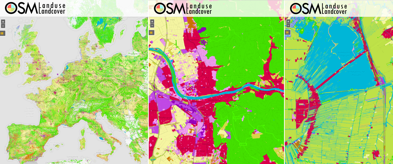
Find here a new update of the OSMlanduse.org map. By injecting known tags provided by OpenStreetMap (OSM) into a remote sensing feature space using deep learning, tags were predicted when absent thus creating a contiguous map – initially for the member states of the EU. By design our method can be applied when- and wherever OSM and Copernicus data is available. Now we eye application for full continental coverage, other continents, and land use evolution. Improvements related to initial processing errors will be deployed soon. Insights will be provided in an upcoming publication authored by researchers Michael Schultz, Hao Li, Zhaoyan Wu, Daniel Wiell, Michael Auer and Alexander Zipf.
Among others, in collaboration with the Joint Research Center (JRC), Ispra and International Institute for Applied Systems Analysis (IIASA) the map is subjected to a online validation campaign that is launched during the EU Regions week the validation event will be initialized on Tue 14, October 2020, 9:30 by Michael Schultz of GIScience Research Group Heidelberg University and Ana-Maria Raimond of IGN France.
Our map is the first successful large area fusion of OSM and Copernicus at 10m spatial resolution or higher, where we acknowledged varying label noise and feature space quality, scales and effective use of artificial intelligence and computing. Our method solely relies on openly available data streams and does not depend on additional expert knowledge.
Brief method outline:
- OSM key value pairs (tags) were translated into Coordination of Information on the Environment (CORINE) land cover (CLC) land use (LU) classes and used as training labels
- Preprocessed Sentinel 2 RGB 10m data for EU was provide from Food and Agriculture Organization (FAO) and used as a feature space
- 1) and 2) were combined to produce a CLC classification of EU using deep learning
The map is developed, deployed and hosted with support from HeiGIT (Heidelberg Institute for Geoinformation Technology).
Related work:
- Li, H.; Ghamisi, P.; Rasti, B.; Wu, Z.; Shapiro, A.; Schultz, M.; Zipf, A. A Multi-Sensor Fusion Framework Based on Coupled Residual Convolutional Neural Networks. Remote Sensing. 2020, 12, 2067. DOI: https://doi.org/10.3390/rs12122067
- Schultz, M., Voss, J., Auer, M., Carter, S., and Zipf, A. (2017): Open land cover from OpenStreetMap and remote sensing. International Journal of Applied Earth Observation and Geoinformation, 63, pp. 206-213. DOI: 10.1016/j.jag.2017.07.014.
- Raimond, A.-M., See L., Schultz, M., Foody, G., Jolivet, L., Le Bris, A., Meneroux, Y., Liu, L., Poupee, M., Gombert, M. (2020): Use of Automated Change Detection and VGI for Identifying and Validating Urban Land Use Change. Remote Sensing
- Schultz, M. (2018): Definition of citizen-observed and authoritative data collection requirements for LandSense demonstration cases. H2020 LandSense. https://doi.org/10.5281/zenodo.3670341
- Wu, Zhaoyan, Li, Hao, & Zipf, Alexander. (2020). From Historical OpenStreetMap data to customized training samples for geospatial machine learning. In proceedings of the Academic Track at the State of the Map 2020 Online Conference, July 4-5 2020. DOI: http://doi.org/10.5281/zenodo.3923040
- Yan, Y., Schultz, M., Zipf, A. (2019): An exploratory analysis of usability of Flickr tags for land use/land cover attribution, Geo-spatial Information Science (GSIS), Taylor & Francis. https://doi.org/10.1080/10095020.2018.1560044
- Jokar Arsanjani, J., Mooney, P., Zipf, A., Schauss, A., (2015): Quality assessment of the contributed land use information from OpenStreetMap versus authoritative datasets. In: Jokar Arsanjani, J., Zipf, A., Mooney, P., Helbich, M., (eds) OpenStreetMap in GIScience: experiences, research, applications. ISBN:978-3-319-14279-1, pp. 37-51, Springer Press.
- Jokar Arsanjani, J., Helbich, M., Bakillah, M., Hagenauer,J. & Zipf, A. (2013): Toward mapping land-use patterns from volunteered geographic information. International Journal of Geographical Information Science (IJGIS). Taylor & Francis. DOI: 10.1080/13658816.2013.800871.
- Dorn, H., Törnros, T. & Zipf, A. (2015): Quality Evaluation of VGI using Authoritative Data – A Comparison with Land Use Data in Southern Germany. ISPRS International Journal of Geo-Information. Vol 4(3), pp. 1657-1671, doi: 10.3390/ijgi4031657
- Li, H., Herfort, B., Huang, W., Zia, M. and Zipf, A. (2020):
Exploration of OpenStreetMap Missing Built-up Areas using Twitter Hierarchical Clustering and Deep Learning in Mozambique. ISPRS Journal of Photogrammetry and Remote Sensing. https://doi.org/10.1016/j.isprsjprs.2020.05.007