• Home
  • About

GIScience News Blog

News of Heidelberg University’s GIScience Research Group.

Feed on
Posts
Comments
« Participate in the virtual Copernikus Hackathon 16-17-18 October! HeiGIT contributes with OSM based services
HeiKA Autumn school Urban Data Science »

New embedded mode for OpenRouteService map client available

Oct 16th, 2020 by Amon Santana

The new openrouteservice map client development is in the final phase and has now a new feature that allows to show routes, isochrones and other features from openrouteservice (ORS) integrated on other websites. This allows webmasters and editors to embed those geographic features into their website using the new client.

How to embed the maps

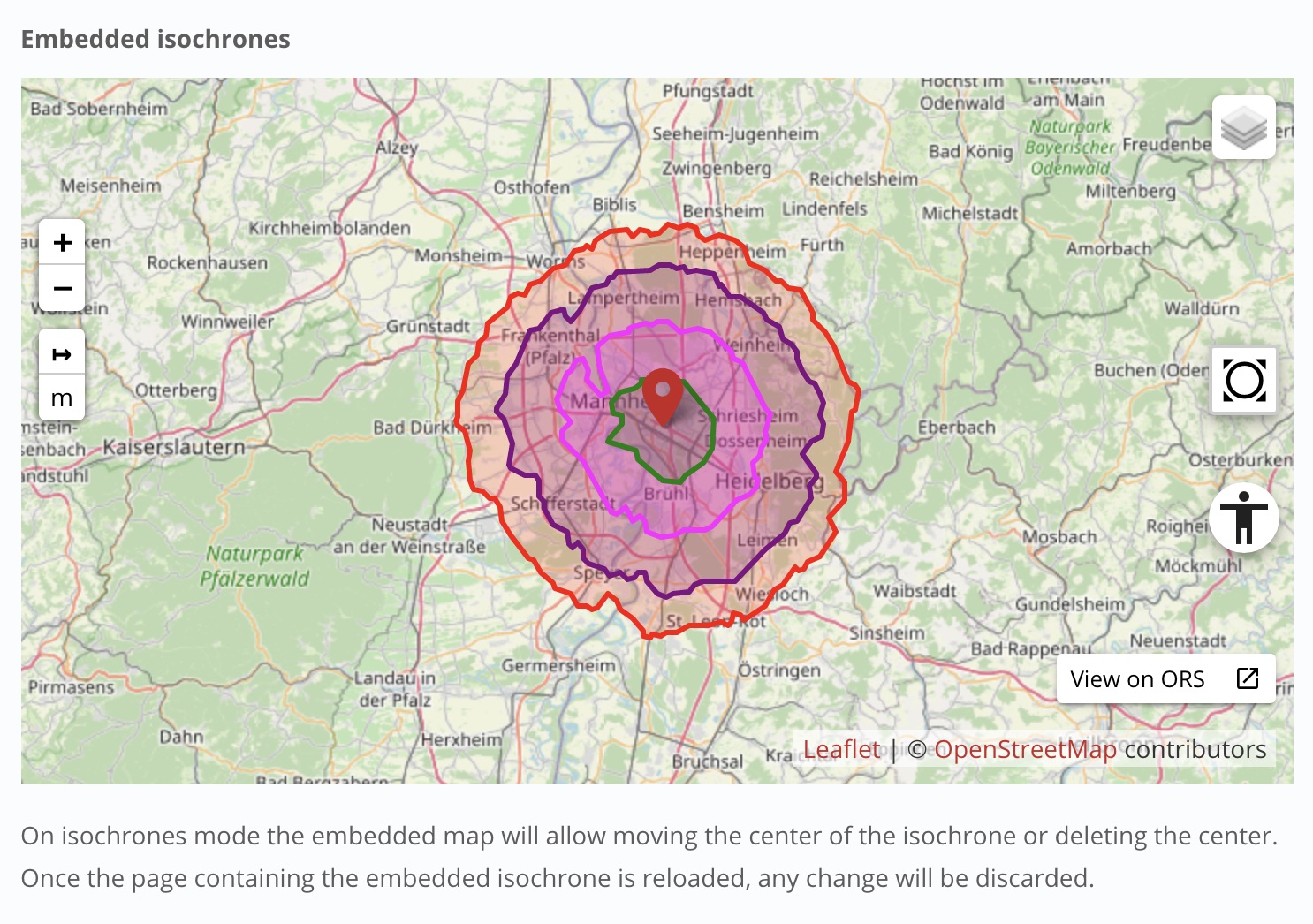
Any feature visualized on the new map client, like a route, isochrones or a place can be used as an embedded content.
The code to be used to embed it is automatically generated on the map client itself. To have access to the code on the sidebar just click on the share option and the iframe code will be available. You just need to click on the code and it will be copied to your clipboard.

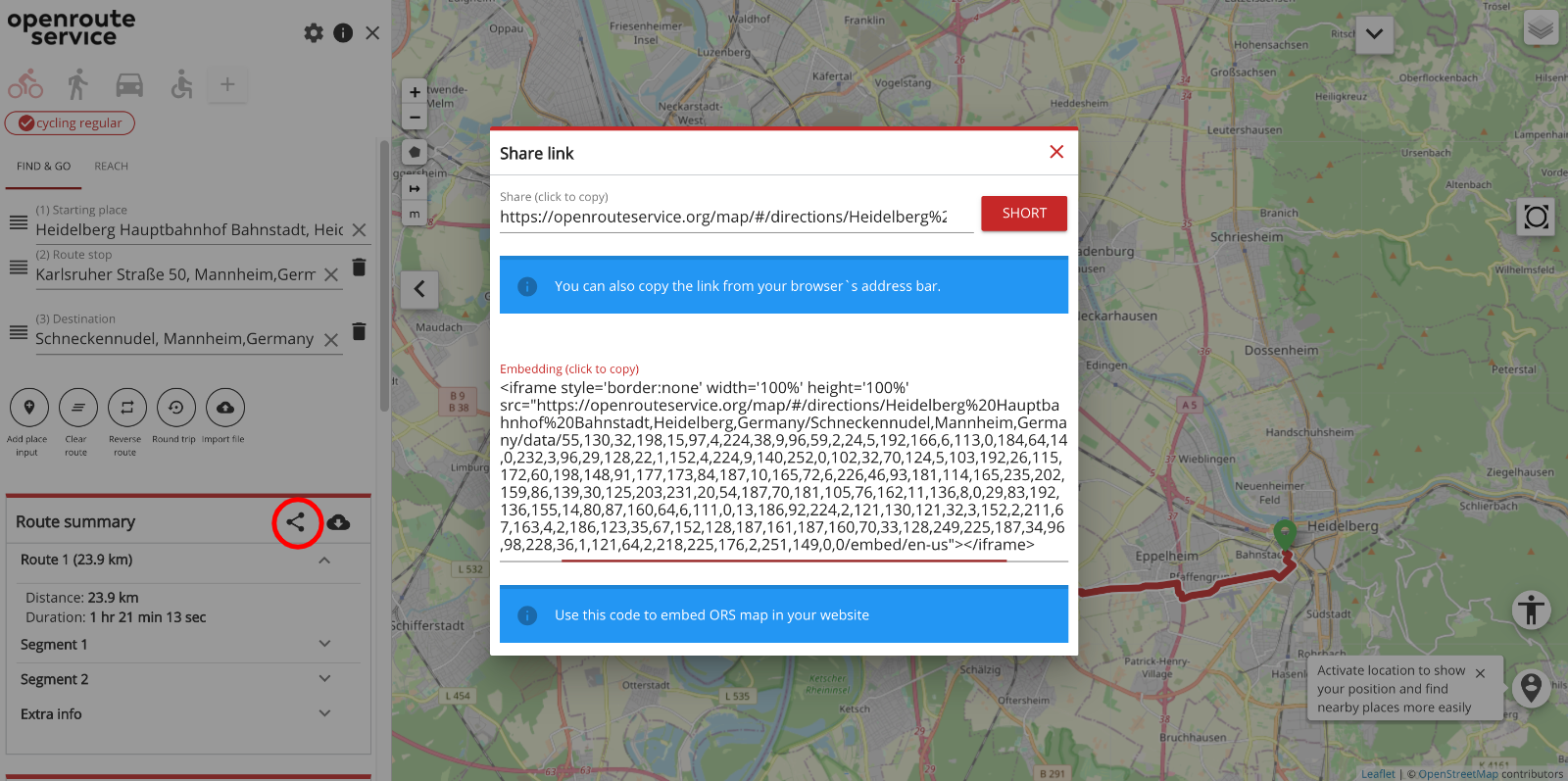
Fig. 1: Access to the embedding code via share

You can find some examples of embedded map views online at:
https://openrouteservice.org/new-embedded-mode-for-openrouteservice-map-client/

(navigate to openrouteservice.org -> Jupyter Examples -> Embedded Mode for openrouteservice VueJS client )

Some features of the embedding mode

– Place information: when clicking on the map, the user can investigate the underlying location. The place information is shown in a popup on the bottom right.

– Measuring distances: by using the measuring control on the left side of the view, the user is able to measure distances on the map in different units. The distances can be discarded by clicking on the control a second time.

– Switching basemap: to view a different map in the background, the user can choose from six different basemaps by hovering over the layer switcher in the top right of the map view.

– Accessibility mode: just like the new VueJs client, the iframe comes with an accessibility mode to navigate the view with the keyboard (arrow keys, tab …) instead of the mouse.

– Zoom to all features: last but not least, there is a button to easily zoom to the full extent of all features (after zooming in/out) on the right hand side of the map view.

- Mobile friendly: like the new map client itself, the embedded map view is also mobile friendly. By default, the iframe code generated used 100% for width and height, so that it can adapt itself to the available dimension.

- User gestures handling: to avoid the map view to be scrolled when the user has the intention to scroll the entire page we added a gesture handling in the embedded mode in order to keep the user in control of it. If the user wants to scroll the map he has to user CTRL + scroll (desktops) or two fingers (mobile) to scroll the map view content.  When the user scrolls the page a message with instructions to scroll the map is displayed over the map view.

- Focused on visualization: most of the interactivity does not work, but the user can click on the  view on ORS button to go to the full version of the client and interact with it.

- Language selection: although only English is supported now on the map client application, soon more languages will be available. When the iframe code is generated, the current defined language is also part of the code, so that when new languages are available the displaying language of the embedded map view will be manageable.

https://openrouteservice.org/new-embedded-mode-for-openrouteservice-map-client/

  • ORS Ref:
    Neis, P. & Zipf, A (2008): OpenRouteService.org is three times “Open”: Combining OpenSource, OpenLS and OpenStreetMaps. GIS Research UK (GISRUK 08). Manchester.

Tags: embedded, map client, maps, openrouteservice, ORS, OSM, routing, Web Maps, WebGIS

Posted in Services, Software

Comments are closed.

  • About

    GIScience News Blog
    News of Heidelberg University’s GIScience Research Group.
    There are 1,484 Posts and 0 Comments so far.

  • Meta

    • Log in
    • Entries RSS
    • Comments RSS
    • WordPress.org
  • Recent Posts

    • Successful PhD Defense by Amin Mobasheri on OSM quality enrichment for wheelchair routing
    • New paper published about the OSM Sketch Map Tool
    • Open Data + Open Software - A perfect match
    • Tagging the main entrances of public buildings based on OpenStreetMap and binary imbalanced learning
    • Press release: Understanding the Spatial and Temporal Dimensions of Landscape Dynamics
  • Tags

    3D 3DGEO Big Spatial Data CAP4Access Citizen Science Colloquium crisis mapping Crowdsourcing data quality disaster DisasterMapping GeoNet.MRN GIScience heigit HOT humanitarian Humanitarian OpenStreetMap team intrinsic quality analysis landuse laser scanning Lidar Mapathon MapSwipe MissingMaps Missing Maps ohsome ohsome example Open data openrouteservice OpenStreetMap OSM OSM History Analytics OSMlanduse Quality quality analysis remote sensing routing social media spatial analysis Teaching terrestrial laser scanning Twitter VGI Wheelchair Navigation Workshop
  • Archives

    • March 2021
    • February 2021
    • January 2021
    • December 2020
    • November 2020
    • October 2020
    • September 2020
    • August 2020
    • July 2020
    • June 2020
    • May 2020
    • April 2020
    • March 2020
    • February 2020
    • January 2020
    • December 2019
    • November 2019
    • October 2019
    • September 2019
    • August 2019
    • July 2019
    • June 2019
    • May 2019
    • April 2019
    • March 2019
    • February 2019
    • January 2019
    • December 2018
    • November 2018
    • October 2018
    • September 2018
    • August 2018
    • July 2018
    • June 2018
    • May 2018
    • April 2018
    • March 2018
    • February 2018
    • January 2018
    • December 2017
    • November 2017
    • October 2017
    • September 2017
    • August 2017
    • July 2017
    • June 2017
    • May 2017
    • April 2017
    • March 2017
    • February 2017
    • January 2017
    • December 2016
    • November 2016
    • October 2016
    • September 2016
    • August 2016
    • July 2016
    • June 2016
    • May 2016
    • April 2016
    • March 2016
    • February 2016
    • January 2016
    • December 2015
    • November 2015
    • October 2015
    • September 2015
    • August 2015
    • July 2015
    • June 2015
    • May 2015
    • April 2015
    • March 2015
    • February 2015
    • January 2015
    • December 2014
    • November 2014
    • October 2014
    • September 2014
    • August 2014
    • July 2014
    • June 2014
    • May 2014
    • April 2014
    • March 2014
    • February 2014
    • January 2014
    • December 2013
    • November 2013
    • October 2013
    • September 2013
    • August 2013
    • July 2013
    • June 2013
    • May 2013
    • April 2013
  •  

    October 2020
    M T W T F S S
    « Sep   Nov »
     1234
    567891011
    12131415161718
    19202122232425
    262728293031  
  • Recent Comments

    GIScience News Blog CC by-nc-sa Some Rights Reserved.

    Free WordPress Themes | Fresh WordPress Themes