• Home
  • About

GIScience News Blog

News of Heidelberg University’s GIScience Research Group.

Feed on
Posts
Comments
« Season’s Greetings from Heidelberg
LandSense Horizon 2020 A Citizen Observatory and Innovation Marketplace for Land Use and Land Cover Monitoring, project successful finished »

Accessibility of covid-19 vaccination centers in Germany

Jan 4th, 2021 by Sven Lautenbach

Updated based on newly available vaccination center locations at the 14th of January 2021.

Vaccination of a sufficiently large share of the population is considered the most important action to fight the spread of SARS-CoV -2 and resulting COVID-19 infections. Germany has started together with the majority of EU member states at the 27th of December 2020 its vaccination campaign. After an initial phase in which mobile teams vaccinate inhabitants of home for the elderly as well as stuff in homes for the elderly and hospitals vaccination centers will be in charge of vaccinating the population. The vaccination centers will later on presumably supported by vaccination by medical practitioners. Till when, easy access to the vaccination centers is one important factor for a successful vaccination campaign. Access to vaccination is by appointment - the procedures differ between the individual federal states.

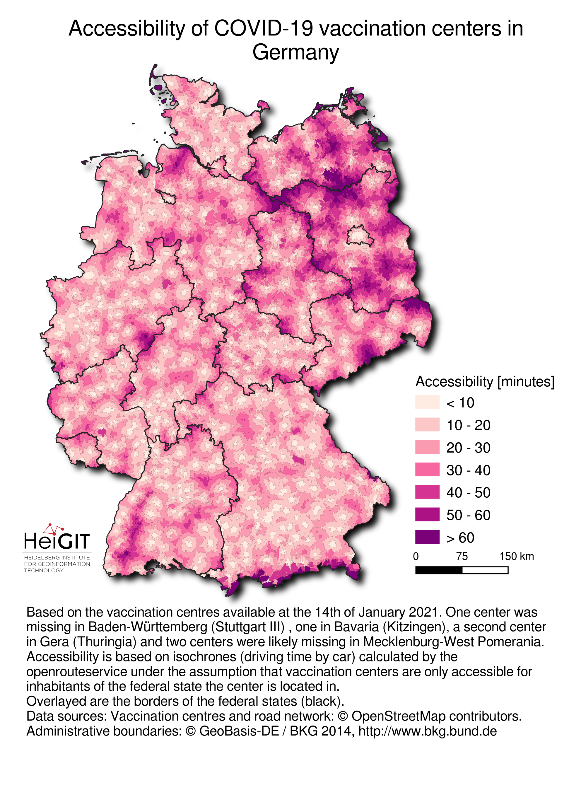
Most federal states in Germany have announced the location of the vaccination centers. The OpenStreetMap community has immediately added this information to its data base - details can be found in the corresponding OSM Wiki page. One center was missing in Baden-Württemberg (Stuttgart III) , one in Bavaria (Kitzingen), a second center in Gera (Thuringia) and two centers were likely missing in Mecklenburg-West Pomerania.

We at HeiGIT have used this information to calculate the accessibility to these centers by means of the openrouteservice. Based on its isochrones functionality we calculated the time required to reach the centers by cars. We distinguished two cases:

  1. unconstrained access to the vaccination centers
  2. access constrained by federal state - i.e. we assumed that only inhabitants of the federal state that host the vaccination center are allowed to access the center
According to news reports the second option is more likely.
In practice access might be further regulated in so far as that vaccination centers might be responsible for one or several districts (German Stadt- und Landkreise). Since details were not known the restrained to investigate this scenario further.
In a later step isochrones were intersected with the 1sqkm population grid based on the latest zensus in 2011.

The map of driving distances indicates that while large parts of Germany have access to the vaccination centers in reasonable driving distances some regions have to face longer driving distances. These are located in less densely populated areas. Please keep in mind that that a few vaccination centers could not be located so far.

The map shows the driving distance to the next vaccination center. State boundaries were considered as barriers for this analysis.

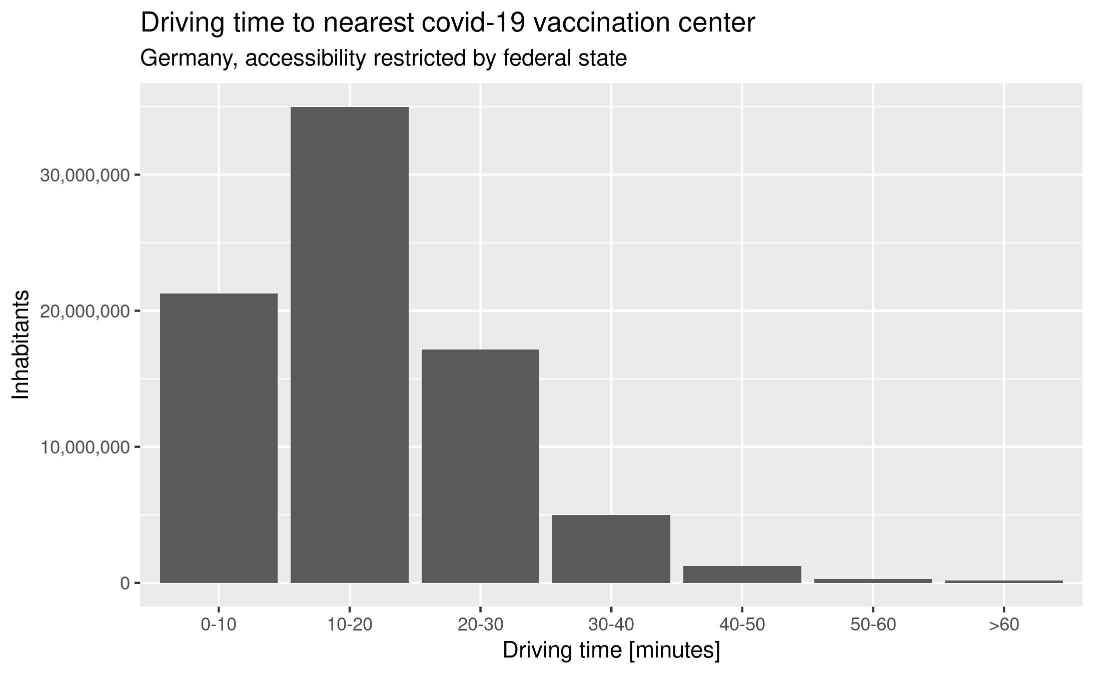
Overall ~27% of inhabitants in the federal states live in driving distance of 10 minutes or less, ~70% in driving distance of 20 minutes or less and 91.6% in driving distance of 30 minutes or less. However, this implies that 6.8 million inhabitants have to face a driving time of more than 30 minutes from which ~190,000 inhabitants have to drive more than one hour - one way.

Population in different driving distances to covid-19 vaccination centers in Germany. Based on the most recent information on the locations of vaccination centers. The analysis considered the borders of the federal states as barriers.

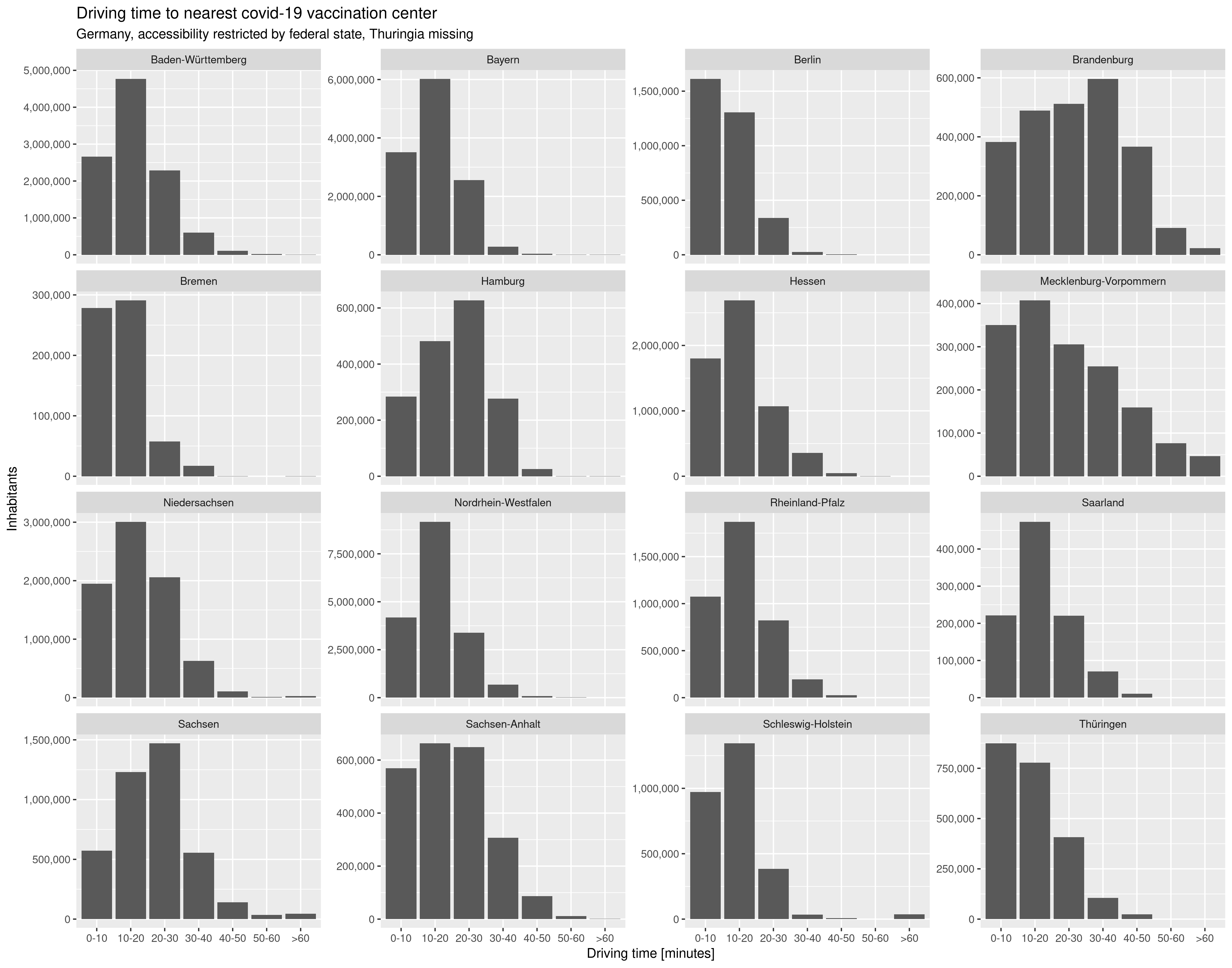
If we look at the individual federal states separately we see an uneven distribution of driving time: especially inhabitants of Brandenburg will have to undertake relatively long journeys to the next vaccination center in the federal state since 43.8% of the inhabitants are living in a driving distance of more than half an hour, from which 4.7% are living farther away than 50 minutes. Inhabitants of Mecklenburg-West Pomerania presumably will also have to face longer average driving distances.

If vaccination centers could also serve inhabitants of other federal states driving distances especially in Brandenburg and Mecklenburg-West Pomerania would improve (results not shown).

Population in different driving distances to COVID-19 vaccination centers in Germany for each federal state separately. Based on the most recent information on the locations of vaccination centers. The analysis considered the borders of the federal states as barriers.

You might also be interested in our analysis of accessibility to pharmacies in Germany with 15km covid-19 restriction,

Some of our earlier work on healthcare / accessiblity using OSM:

  • Mapping physical access to health-care for older adults in sub-saharan-africa and implications for the covid-19-response - a cross-sectional analysis
  • Exploring OSM for healthcare access analysis in Sub-Saharan-Africa
  • OSM-Completeness of health-facilities in Sub-Sahara-Africa
  • Recent changes to openstreetmap healthcare infrastructure in India
  • New jupyter notebook: Analysis of access to health-care using openrouteservice isochrones-api-2
  • Exploring OSM history - the example of health related amenities
  • Quota for openrouteservice multi-vehicle-optimization increased to support logistics during corona-crisis
  • Data-journalism-webapp about accessibility in sweden according to corona travel recommendations
  • 25-mapathons: online-mapathon at humanitarian congress
  • HeiGIT participates at virtual HOT-Summit-2020
  • Healthsites.io and HeiGIT establish partnership

Tags: Accessibility, corona, COVID-19, healthcare, isochrones, openrouteservice, OpenStreetMap, ORS, Public Health

Posted in OSM, Press release, Public Health, Research

Comments are closed.

  • About

    GIScience News Blog
    News of Heidelberg University’s GIScience Research Group.
    There are 1,674 Posts and 0 Comments so far.

  • Meta

    • Log in
    • Entries RSS
    • Comments RSS
    • WordPress.org
  • Recent Posts

    • New paper on the automatic characterization of surface activities from 4D point clouds
    • OSHDB Version 1.0 Has Arrived
    • Job Opening for Postdoc / Senior Researcher on OpenStreetMap Road Quality Analysis
    • Geography Awareness Week 14.-19.11.2022
    • Open Data: Multi-platform point clouds and orthophotos of the inland dune in Sandhausen
  • Tags

    3D 3DGEO Big Spatial Data CAP4Access Citizen Science Conference crisis mapping Crowdsourcing data quality deep learning disaster DisasterMapping GeoNet.MRN GIScience heigit HOT humanitarian humanitarian mapping Humanitarian OpenStreetMap team intrinsic quality analysis landuse laser scanning Lidar machine-learning Mapathon MapSwipe MissingMaps Missing Maps ohsome ohsome example Open data openrouteservice OpenStreetMap OSM OSM History Analytics Public Health Quality quality analysis remote sensing routing social media spatial analysis Teaching VGI Workshop
  • Archives

    • December 2022
    • November 2022
    • October 2022
    • September 2022
    • August 2022
    • July 2022
    • June 2022
    • May 2022
    • April 2022
    • March 2022
    • February 2022
    • January 2022
    • December 2021
    • November 2021
    • October 2021
    • September 2021
    • August 2021
    • July 2021
    • June 2021
    • May 2021
    • April 2021
    • March 2021
    • February 2021
    • January 2021
    • December 2020
    • November 2020
    • October 2020
    • September 2020
    • August 2020
    • July 2020
    • June 2020
    • May 2020
    • April 2020
    • March 2020
    • February 2020
    • January 2020
    • December 2019
    • November 2019
    • October 2019
    • September 2019
    • August 2019
    • July 2019
    • June 2019
    • May 2019
    • April 2019
    • March 2019
    • February 2019
    • January 2019
    • December 2018
    • November 2018
    • October 2018
    • September 2018
    • August 2018
    • July 2018
    • June 2018
    • May 2018
    • April 2018
    • March 2018
    • February 2018
    • January 2018
    • December 2017
    • November 2017
    • October 2017
    • September 2017
    • August 2017
    • July 2017
    • June 2017
    • May 2017
    • April 2017
    • March 2017
    • February 2017
    • January 2017
    • December 2016
    • November 2016
    • October 2016
    • September 2016
    • August 2016
    • July 2016
    • June 2016
    • May 2016
    • April 2016
    • March 2016
    • February 2016
    • January 2016
    • December 2015
    • November 2015
    • October 2015
    • September 2015
    • August 2015
    • July 2015
    • June 2015
    • May 2015
    • April 2015
    • March 2015
    • February 2015
    • January 2015
    • December 2014
    • November 2014
    • October 2014
    • September 2014
    • August 2014
    • July 2014
    • June 2014
    • May 2014
    • April 2014
    • March 2014
    • February 2014
    • January 2014
    • December 2013
    • November 2013
    • October 2013
    • September 2013
    • August 2013
    • July 2013
    • June 2013
    • May 2013
    • April 2013
  •  

    January 2021
    M T W T F S S
    « Dec   Feb »
     123
    45678910
    11121314151617
    18192021222324
    25262728293031
  • Recent Comments

    GIScience News Blog CC by-nc-sa Some Rights Reserved.

    Free WordPress Themes | Fresh WordPress Themes