
Time series of topographic point clouds offer great possibilities to advance our understanding of dynamic landscapes. To exploit the full information these 4D datasets contain on spatial and temporal properties of natural surface changes, the 3DGeo research group is developing methods for 4D change analysis. These methods are required to answer fundamental questions on the dynamics of natural landscapes:
(1) When and where do changes occur?
(2) How do changes occur (e.g. magnitudes, directions)?
(3) How (well) can we detect changes?
An important improvement that was just published by Williams et al. (2021) is to consider the direction of changes in the detection process. Within this article, we present a data-driven method to find a dominant movement direction (DMD) by considering local changes in multiple directions. Our work shows that it is important to consider the direction along which change is measured. So far, comparisons of the topography are often done in the direction of the local surface. But natural change processes often do not occur orthogonal to the surface, for example in the case of rock falls or rock glacier creep.
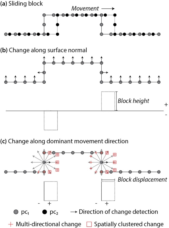
Multi-directional change quantification provides an important alternative view of movement where
(1) movement processes operate in a direction that is not surface-normal,
(2) the underlying process(es) may not be known, and
(3) movement(s) across the point cloud scene is not oriented along a single axis
Find all details in the full paper (get free access here until 9 February 2021)
Williams, J.G., Anders, K., Winiwarter, L., Zahs, V., Höfle, B. (2021): Multi-directional change detection between point clouds. ISPRS Journal of Photogrammetry and Remote Sensing. Vol. 172, pp. 95-113. https://doi.org/10.1016/j.isprsjprs.2020.12.002.
In another study, we tackle the challenge that topographic change at a given location usually results from multiple processes operating over different timescales (Ulrich et al., 2021). Interpretations of surface change are often based upon single values of movement, measured over a fixed time period or in a single direction. For the example of a rock glacier, we improve this by assessing movement along different directions (normal to the surface and in the direction of rock glacier flow) over different temporal intervals. By this, we are able to show that change processes feature different magnitudes and directions over different intervals and to separate different processes of change that are superimposed and would hence be hidden in longer observation periods. The article also highlights the importance of multi-directional change and increased temporal resolution in the setup of future observation networks.
Ulrich, V., Williams, J.G., Zahs, V., Anders, K., Hecht, S., Höfle, B. (2021): Measurement of rock glacier surface change over different timescales using terrestrial laser scanning point clouds. Earth Surface Dynamics. Vol. 9, pp. 19-28. https://doi.org/10.5194/esurf-9-19-2021.
Stay tuned for new methods on other aspects of 4D change analysis coming soon!
In the meantime, check out a recent video on 4D change analysis within the Auto3Dscapes project. Or find out what is being done on 4D change analysis in the GEODYNAMO4D and AHK-4D projects.