• Home
  • About

GIScience News Blog

News of Heidelberg University’s GIScience Research Group.

Feed on
Posts
Comments
« Behind the scenes of the ohsome quality analyst (OQT)
Introducing the Open Healthcare Access Map »

New publication on the Impact of Community Happenings in OpenStreetMap

Mar 24th, 2021 by Moritz Schott

Online knowledge projects such as OpenStreetMap (OSM) and Wikipedia have gained high importance, trust and even economic value. These projects and their content are maintained and enhanced by online communities that evolve around them. Yet, these communities and their members are often ignored when the respective data or knowledge is used.

In a recent publication a systematic framework is established, to enable a comparable analyses of members of online communities. The framework is tailored towards Volunteered Geographic Information (VGI) but can be easily adapted to any online community that allows and enables the analyses of contributions made by single members.

Influences or context a mapper is exposed to while making a contribution i.e. characteristics of a contribution.

Influences or context a mapper is exposed to while making a contribution i.e. characteristics of a contribution.

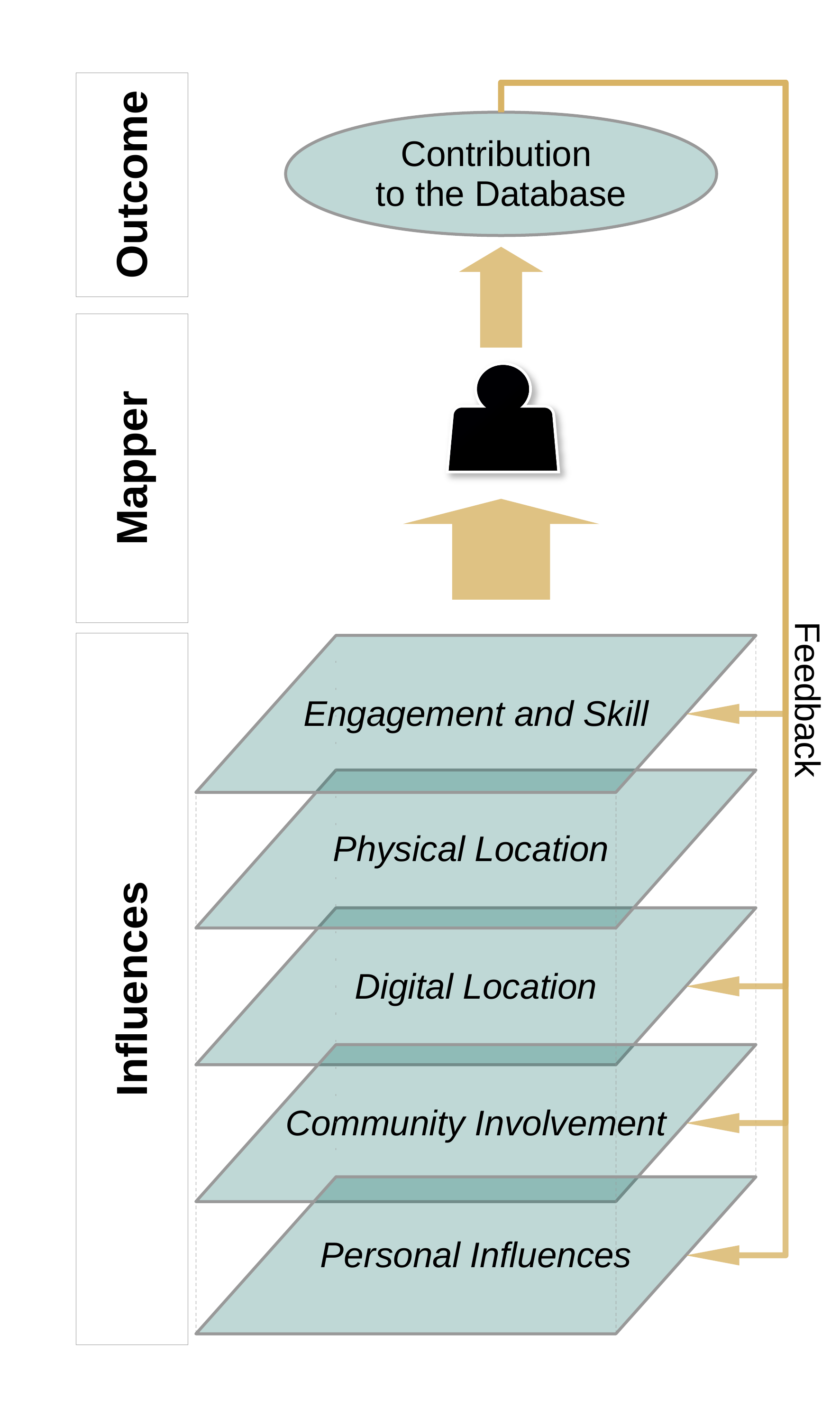
The framework identifies a set of dimensions of contextual effect that influence the shape of a contribution to the project. The framework is tested on a specific use-case in OSM: Community Happenings. These happenings, so called mapathons, play a large role in OSM to foster the exchange between mappers but also to tackle a current need for OSM data such as in the aftermath of a humanitarian crisis. To analyse how mapathons change the way mappers contribute to the OSM project, each dimension of the framework was implemented into a set of measurable data proxies. The configuration of these proxies was then computed and compared before and after mapathons.

A hypothetical trajectory of mapping behaviour of a model mapper taking part in a happening along the five abstract dimensions of contextual effects.

A hypothetical trajectory of mapping behaviour of a model mapper taking part in a happening along the five abstract dimensions of contextual effects.

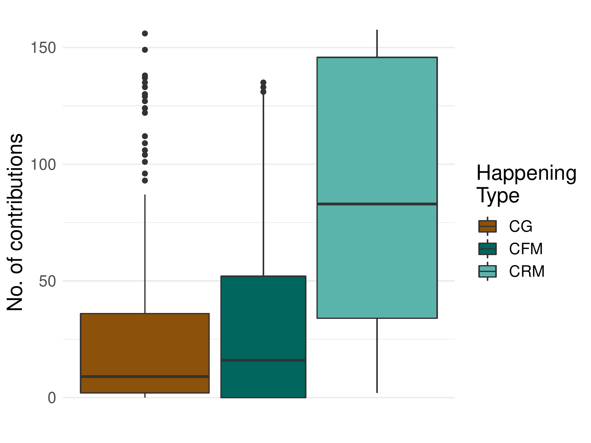
This allowed for a precise description of where, when and how strong mapathons affect their participants and which groups are affected. Happenings that targeted remote regions were compared to happenings that targeted the immediate surrounding of the events venue. In addition newcomers were analysed separately from advanced mappers. All groups were compared to a control group.

Results showed that newcomers adopted a contribution behaviour similar to the contribution behaviour typical for the respective happening they attended: when contributing after the happening, newcomers who attended a remote mapping event tended to concentrate on creating new data with lower quality but high quantity in places foreign to their home region; newcomers who attended a field mapping event updated and enhanced existing local data with high accuracy. The behaviour of advanced mappers stayed largely unaffected by happenings. Unfortunately, our results did not reveal a positive effect on the community integration of newcomers through happenings.

Quantity of contributions for happening participants during events. CFM - Field mapping event; CRM - Remote mapping event, CG - Control group

Quantity of contributions for happening participants during events. CFM - Field mapping event; CRM - Remote mapping event; CG - Control group

Schott, M.; Grinberger, A. Y.; Lautenbach, S. & Zipf, A. (2021) The Impact of Community Happenings in OpenStreetMap – Establishing a Framework for Online Community Member Activity Analyses In: ISPRS Int. J. Geo-Inf. 10, no. 3: 164. https://doi.org/10.3390/ijgi10030164

Related work (selection):

Herfort, B.; Lautenbach, S.; de Albuquerque, J.P.; Anderson, J.; Zipf, A. The evolution of humanitarian mapping within the OpenStreetMap community. Sci. Rep. 2021, 11. [CrossRef]

Raifer, M.; Troilo, R.; Kowatsch, F.; Auer, M.; Loos, L.; Marx, S.; Przybill, K.; Fendrich, S.; Mocnik, F.B.; Zipf, A. OSHDB: A framework for spatio-temporal analysis of OpenStreetMap history data. Open Geospat. Data Softw. Stand. 2019, 4, 3. [CrossRef]

Grinberger, AY, Schott, M, Raifer, M, Zipf, A. (2021): An analysis of the spatial and temporal distribution of large‐scale data production events in OpenStreetMap. Transactions in GIS. 2021; 00: 1– 20. https://doi.org/10.1111/tgis.12746

Auer, M.; Eckle, M.; Fendrich, S.; Griesbaum, L.; Kowatsch, F.; Marx, S.; Raifer, M.; Schott, M.; Troilo, R.; Zipf, A. (2018): Towards Using the Potential of OpenStreetMap History for Disaster Activation Monitoring. ISCRAM 2018. Rochester. NY. US.Eckle, M.; de Albuquerque, J.P. Quality Assessment of Remote Mapping in OpenStreetMap for Disaster Management Purposes. In Proceedings of the ISCRAM 2015 Conference, Krystiansand, Norway, 24–27 May 2015.

Yan, Y., C. Feng, W. Huang, H. Fan, Y. Wang & A. Zipf (2020): Volunteered geographic information research in the first decade: a narrative review of selected journal articles in GIScience. International Journal of Geographical Information Science, DOI: 10.1080/13658816.2020.1730848

See also ohsome.org

Tags: Mapathon, ohsome, Online Community, OSM, OSM History Analytics, Research, user analyses, VGI

Posted in OSM, Publications, Research, VGI Group

Comments are closed.

  • About

    GIScience News Blog
    News of Heidelberg University’s GIScience Research Group.
    There are 1,500 Posts and 0 Comments so far.

  • Meta

    • Log in
    • Entries RSS
    • Comments RSS
    • WordPress.org
  • Recent Posts

    • HELIOS++ v1.0.6 released
    • HeiGIT und DRK veröffentlichen weiteres Trainingsmaterial zu Mapathons 
    • German Mass Vaccination Sites in Open Healthcare Access Map
    • ohsome-py: Python Package for OSM history analytics published
    • Mapathon “Mapping for International Solidarity” on 06.04
  • Tags

    3D 3DGEO Big Spatial Data CAP4Access Citizen Science Colloquium crisis mapping Crowdsourcing data quality disaster DisasterMapping GeoNet.MRN GIScience heigit HOT humanitarian Humanitarian OpenStreetMap team intrinsic quality analysis isochrones landuse laser scanning Lidar Mapathon MapSwipe Missing Maps MissingMaps ohsome ohsome example Open data openrouteservice OpenStreetMap OSM OSM History Analytics OSMlanduse Quality quality analysis remote sensing routing social media spatial analysis Teaching terrestrial laser scanning VGI Wheelchair Navigation Workshop
  • Archives

    • April 2021
    • March 2021
    • February 2021
    • January 2021
    • December 2020
    • November 2020
    • October 2020
    • September 2020
    • August 2020
    • July 2020
    • June 2020
    • May 2020
    • April 2020
    • March 2020
    • February 2020
    • January 2020
    • December 2019
    • November 2019
    • October 2019
    • September 2019
    • August 2019
    • July 2019
    • June 2019
    • May 2019
    • April 2019
    • March 2019
    • February 2019
    • January 2019
    • December 2018
    • November 2018
    • October 2018
    • September 2018
    • August 2018
    • July 2018
    • June 2018
    • May 2018
    • April 2018
    • March 2018
    • February 2018
    • January 2018
    • December 2017
    • November 2017
    • October 2017
    • September 2017
    • August 2017
    • July 2017
    • June 2017
    • May 2017
    • April 2017
    • March 2017
    • February 2017
    • January 2017
    • December 2016
    • November 2016
    • October 2016
    • September 2016
    • August 2016
    • July 2016
    • June 2016
    • May 2016
    • April 2016
    • March 2016
    • February 2016
    • January 2016
    • December 2015
    • November 2015
    • October 2015
    • September 2015
    • August 2015
    • July 2015
    • June 2015
    • May 2015
    • April 2015
    • March 2015
    • February 2015
    • January 2015
    • December 2014
    • November 2014
    • October 2014
    • September 2014
    • August 2014
    • July 2014
    • June 2014
    • May 2014
    • April 2014
    • March 2014
    • February 2014
    • January 2014
    • December 2013
    • November 2013
    • October 2013
    • September 2013
    • August 2013
    • July 2013
    • June 2013
    • May 2013
    • April 2013
  •  

    March 2021
    M T W T F S S
    « Feb   Apr »
    1234567
    891011121314
    15161718192021
    22232425262728
    293031  
  • Recent Comments

    GIScience News Blog CC by-nc-sa Some Rights Reserved.

    Free WordPress Themes | Fresh WordPress Themes