• Home
  • About

GIScience News Blog

News of Heidelberg University’s GIScience Research Group.

Feed on
Posts
Comments
« All countries of Central and South America now on Open Healthcare Access Map
Becoming ohsome in R - analysis of the completeness of the road network and health sites in Jakarta »

The ohsome quality analyst goes public on Github with new release 0.3.0

May 19th, 2021 by Benjamin Herfort

The ohsome quality analyst (short: OQT) has been introduced at the beginning of this year and today we are proud to announce two updates.

First, we  released the new version 0.3.0 which includes new OSM layers and a brand new data quality report. Working on this release has been the first collaboration with MapAction under the umbrella of the memorandum of understanding between HeiGIT and MapAction. Here we started to outline data quality needs for the MapAction map products. Based on this a first report - MapAction Country Overview Report - has been implemented and is now available through the website. Discussing how data quality indicators relate to the specific usage of OSM data has been a central part of the work in the past weeks. With our work on OQT we try to bring these two domains closer to each other.

With this release it is now also much easier to use OQT from your command line to calculate the data quality for the regions you are interested in. For this you just need to install it locally and prepare a geojson file with the geometries of your area of interest. This can be especially useful when you are interested in regions that are not yet covered on our website. Feel free to get in contact with us (ohsome@heigit.org) and let us know about your challenges.

Second, we are happy to work on OQT from now on publicly on Github. This is another important step for us to make sure that we can work closely together with other researchers, practitioners and OSM communities. Today OQT joins our other open source software tools such as the OSDHB, ohsome API and openrouteservice. We welcome your suggestions and contributions.

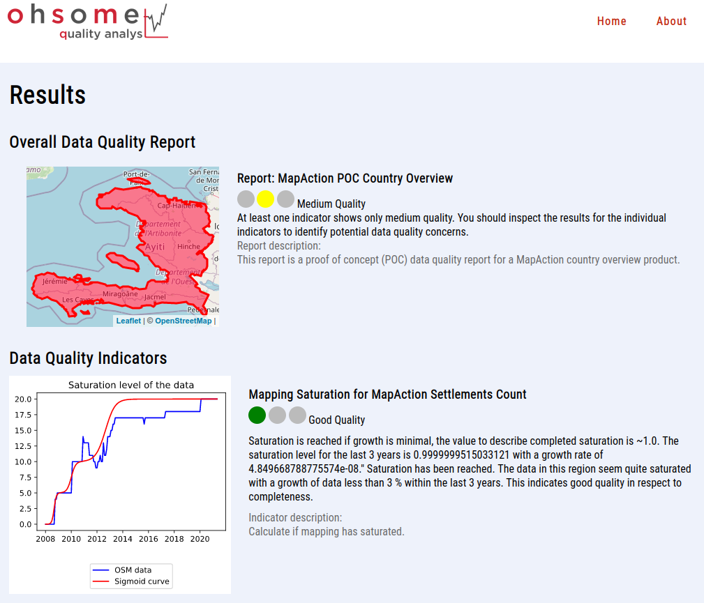
Figure: MapAction Country Overview Report for Haiti

Related work:

OQT relies on information from the OpenStreetMap (OSM) that has been processed using the ohsome OSM History Data Analytics Platform developed by HeiGIT. The aim of the ohsome framework is to make OpenStreetMap’s full-history data more easily accessible for various kinds of OSM data analytics tasks, such as data quality analysis, on a regional, country-wide, or global scale. Here you find a list of related blog posts and publications:

Blogposts

  • Introducing the ohsome quality analyst (OQT)
  • Behind the scenes of the ohsome quality analyst (OQT)
  • ohsome general idea
  • ohsome general architecture
  • how to become ohsome blog series

Publications

  • Raifer, Martin; Troilo, Rafael; Kowatsch, Fabian; Auer, Michael; Loos, Lukas; Marx, Sabrina; Przybill, Katharina; Fendrich, Sascha; Mocnik, Franz-Benjamin; Zipf, Alexander (2019): OSHDB: a framework for spatio-temporal analysis of OpenStreetMap history data. Open Geospatial Data, Software and Standards.
  • Herfort, B., Lautenbach, S., Porto de Albuquerque, J., Anderson, J., Zipf, A.The evolution of humanitarian mapping within the OpenStreetMap community. Scientific Reports 11, 3037 (2021). DOI: 10.1038/s41598-021-82404-z  https://www.nature.com/articles/s41598-021-82404-z
  • Schott, M.; Grinberger, A. Y.; Lautenbach, S. & Zipf, A. (2021) The Impact of Community Happenings in OpenStreetMap – Establishing a Framework for Online Community Member Activity Analyses In: ISPRS Int. J. Geo-Inf. 10, no. 3: 164. https://doi.org/10.3390/ijgi10030164
  • Grinberger, AY, Schott, M, Raifer, M, Zipf, A. (2021): An analysis of the spatial and temporal distribution of large‐scale data production events in OpenStreetMap. Transactions in GIS. 2021; 00: 1– 20. https://doi.org/10.1111/tgis.12746

Tags: data quality, extrinsic quality analysis, heigit, intrinsic quality analysis, ohsome, oqt, OSM

Posted in OSM, Services, Software, Uncategorized

Comments are closed.

  • About

    GIScience News Blog
    News of Heidelberg University’s GIScience Research Group.
    There are 1,651 Posts and 0 Comments so far.

  • Meta

    • Log in
    • Entries RSS
    • Comments RSS
    • WordPress.org
  • Recent Posts

    • UndercoverEisAgenten on the road
    • Danziger Scholarship Applications Extended to Aug. 31
    • An ohsome way to check if OSM is up to date
    • HeiGIT at MSF Geo Week 2022
    • Open GIScience PostDoc positions on understanding the relationships between “Urban nature experience, biodiversity and mental health”
  • Tags

    3D 3DGEO Big Spatial Data CAP4Access Citizen Science Climate Change Conference crisis mapping Crowdsourcing data quality deep learning disaster DisasterMapping GeoNet.MRN GIScience heigit HOT humanitarian humanitarian mapping Humanitarian OpenStreetMap team intrinsic quality analysis landuse laser scanning Lidar machine-learning Mapathon MapSwipe Missing Maps MissingMaps ohsome ohsome example Open data openrouteservice OpenStreetMap OSM OSM History Analytics Quality quality analysis remote sensing routing social media spatial analysis Teaching VGI Workshop
  • Archives

    • August 2022
    • July 2022
    • June 2022
    • May 2022
    • April 2022
    • March 2022
    • February 2022
    • January 2022
    • December 2021
    • November 2021
    • October 2021
    • September 2021
    • August 2021
    • July 2021
    • June 2021
    • May 2021
    • April 2021
    • March 2021
    • February 2021
    • January 2021
    • December 2020
    • November 2020
    • October 2020
    • September 2020
    • August 2020
    • July 2020
    • June 2020
    • May 2020
    • April 2020
    • March 2020
    • February 2020
    • January 2020
    • December 2019
    • November 2019
    • October 2019
    • September 2019
    • August 2019
    • July 2019
    • June 2019
    • May 2019
    • April 2019
    • March 2019
    • February 2019
    • January 2019
    • December 2018
    • November 2018
    • October 2018
    • September 2018
    • August 2018
    • July 2018
    • June 2018
    • May 2018
    • April 2018
    • March 2018
    • February 2018
    • January 2018
    • December 2017
    • November 2017
    • October 2017
    • September 2017
    • August 2017
    • July 2017
    • June 2017
    • May 2017
    • April 2017
    • March 2017
    • February 2017
    • January 2017
    • December 2016
    • November 2016
    • October 2016
    • September 2016
    • August 2016
    • July 2016
    • June 2016
    • May 2016
    • April 2016
    • March 2016
    • February 2016
    • January 2016
    • December 2015
    • November 2015
    • October 2015
    • September 2015
    • August 2015
    • July 2015
    • June 2015
    • May 2015
    • April 2015
    • March 2015
    • February 2015
    • January 2015
    • December 2014
    • November 2014
    • October 2014
    • September 2014
    • August 2014
    • July 2014
    • June 2014
    • May 2014
    • April 2014
    • March 2014
    • February 2014
    • January 2014
    • December 2013
    • November 2013
    • October 2013
    • September 2013
    • August 2013
    • July 2013
    • June 2013
    • May 2013
    • April 2013
  •  

    May 2021
    M T W T F S S
    « Apr   Jun »
     12
    3456789
    10111213141516
    17181920212223
    24252627282930
    31  
  • Recent Comments

    GIScience News Blog CC by-nc-sa Some Rights Reserved.

    Free WordPress Themes | Fresh WordPress Themes