• Home
  • About

GIScience News Blog

News of Heidelberg University’s GIScience Research Group.

Feed on
Posts
Comments
« Becoming ohsome in R - analysis of the completeness of the road network and health sites in Jakarta
Methods and algorithms for 3D/4D change analysis and virtual laser scanning »

Automatic building detection with ohsome2label and Tensorflow

May 31st, 2021 by Hao Li

Accurate and complete geographic data of human settlement is crucial for humanitarian aid and disaster response. OpenStreetMap (OSM) can serve as a valuable source, especially for global south countries where buildings are largely unmapped. In a previous blog, we introduced our recent work in detecting OpenStreetMap missing buildings, so this time we will show you a walkthrough on how to train your own building detector using ohsome2label and the TensorFlow Object Detection API. You can find all the necessary scripts and detailed walkthrough tutorials in our GitHub repo.

The open-source package ohsome2label offers a flexible framework for labeling customized geospatial objects (e.g., buildings) using OSM data and satellite imagery, which aims to mitigate the lack of abundant high-quality training samples in geospatial deep learning by automatically extracting customized OSM historical features.

By integrating various satellite imagery APIs, ohsome2label enables seamless training with the-state-of-art deep learning framework (e.g., Tensorflow) via providing standard training data, for instance the Microsoft COCO JSON format. In this walkthrough, we demonstrate how one can easily acquire the OSM training data for a building detection model.

Fig.1: Preview of OSM training samples generated by ohsome2label.

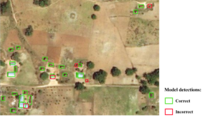
Once the training data is prepared, there will be diverse base models in the Tensorflow model zoo that one can fine-tune to detect buildings in almost any area. In the walkthrough, an example of the fine-tuned model was trained and evaluated for the rural Kalola area, in Tanzania. Moreover, we’ve created utility scripts to easily transform the building detection results into vector data with detailed geographical coordinates, with which one can do further GIS analysis.

Fig.2: Predicted building geometries compared to OSM data.

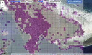
With the ongoing DeepVGI project, the method shown in the walkthrough has been implemented to identify missing OSM buildings in several selected countries, for example, India, Tanzania, and Mozambique. For more details, you are welcome to explore our MissingOSM maps to see where do we need to map in OpenStreetMap next?

Fig.3: MissingOSM maps: where do we need to map in OpenStreetMap next?

Cannot wait to try this by yourself? Check out the detailed walkthrough on GitHub. Let us know how it works or if you are interested in any other use cases of ohsome2label. Stay ohsome!

Tags: deep learning, deepVGI, MissingOSM, ohsome, ohsome2label, OpenStreetMap

Posted in OSM, Research, Software

Comments are closed.

  • About

    GIScience News Blog
    News of Heidelberg University’s GIScience Research Group.
    There are 1,674 Posts and 0 Comments so far.

  • Meta

    • Log in
    • Entries RSS
    • Comments RSS
    • WordPress.org
  • Recent Posts

    • New paper on the automatic characterization of surface activities from 4D point clouds
    • OSHDB Version 1.0 Has Arrived
    • Job Opening for Postdoc / Senior Researcher on OpenStreetMap Road Quality Analysis
    • Geography Awareness Week 14.-19.11.2022
    • Open Data: Multi-platform point clouds and orthophotos of the inland dune in Sandhausen
  • Tags

    3D 3DGEO Big Spatial Data CAP4Access Citizen Science Conference crisis mapping Crowdsourcing data quality deep learning disaster DisasterMapping GeoNet.MRN GIScience heigit HOT humanitarian humanitarian mapping Humanitarian OpenStreetMap team intrinsic quality analysis landuse laser scanning Lidar machine-learning Mapathon MapSwipe MissingMaps Missing Maps ohsome ohsome example Open data openrouteservice OpenStreetMap OSM OSM History Analytics Public Health Quality quality analysis remote sensing routing social media spatial analysis Teaching VGI Workshop
  • Archives

    • December 2022
    • November 2022
    • October 2022
    • September 2022
    • August 2022
    • July 2022
    • June 2022
    • May 2022
    • April 2022
    • March 2022
    • February 2022
    • January 2022
    • December 2021
    • November 2021
    • October 2021
    • September 2021
    • August 2021
    • July 2021
    • June 2021
    • May 2021
    • April 2021
    • March 2021
    • February 2021
    • January 2021
    • December 2020
    • November 2020
    • October 2020
    • September 2020
    • August 2020
    • July 2020
    • June 2020
    • May 2020
    • April 2020
    • March 2020
    • February 2020
    • January 2020
    • December 2019
    • November 2019
    • October 2019
    • September 2019
    • August 2019
    • July 2019
    • June 2019
    • May 2019
    • April 2019
    • March 2019
    • February 2019
    • January 2019
    • December 2018
    • November 2018
    • October 2018
    • September 2018
    • August 2018
    • July 2018
    • June 2018
    • May 2018
    • April 2018
    • March 2018
    • February 2018
    • January 2018
    • December 2017
    • November 2017
    • October 2017
    • September 2017
    • August 2017
    • July 2017
    • June 2017
    • May 2017
    • April 2017
    • March 2017
    • February 2017
    • January 2017
    • December 2016
    • November 2016
    • October 2016
    • September 2016
    • August 2016
    • July 2016
    • June 2016
    • May 2016
    • April 2016
    • March 2016
    • February 2016
    • January 2016
    • December 2015
    • November 2015
    • October 2015
    • September 2015
    • August 2015
    • July 2015
    • June 2015
    • May 2015
    • April 2015
    • March 2015
    • February 2015
    • January 2015
    • December 2014
    • November 2014
    • October 2014
    • September 2014
    • August 2014
    • July 2014
    • June 2014
    • May 2014
    • April 2014
    • March 2014
    • February 2014
    • January 2014
    • December 2013
    • November 2013
    • October 2013
    • September 2013
    • August 2013
    • July 2013
    • June 2013
    • May 2013
    • April 2013
  •  

    May 2021
    M T W T F S S
    « Apr   Jun »
     12
    3456789
    10111213141516
    17181920212223
    24252627282930
    31  
  • Recent Comments

    GIScience News Blog CC by-nc-sa Some Rights Reserved.

    Free WordPress Themes | Fresh WordPress Themes