• Home
  • About

GIScience News Blog

News of Heidelberg University’s GIScience Research Group.

Feed on
Posts
Comments
« Routenplanung im Überflutungsgebiet: openrouteservice nutzt Copernicus EMS Flut-Daten in spezieller Lösung
The role of data in transformations to sustainability: a critical research agenda »

Open laser scanning data of trees - SYSSIFOSS project

Jul 29th, 2021 by Hannah Weiser

Our forest laser scanning dataset collected in the frame of the SYSSIFOSS project is now openly available through the PANGAEA Data Publisher:

Weiser, H., Schäfer, J., Winiwarter, L., et al. (2021): Terrestrial, UAV-borne and airborne laser scanning point clouds of central European forest plots, Germany, with extracted individual trees and manual forest inventory measurements. PANGAEA, https://doi.org/10.1594/PANGAEA.933426

Until the DOI is registered, the dataset can be accessed here.

In 2019 and 2020, we acquired 3D forest data with laser scanners mounted on three different platforms: an aircraft, an uncrewed aerial vehicle (UAV) and a ground-based tripod. The point cloud datasets differ in their coverage, resolution and view directions. Airborne laser scanning (ALS) and terrestrial laser scanning (TLS) was conducted during summertime under leaf-on conditions. UAV-borne laser scanning (ULS) was performed both in summer and early spring, resulting in 3D point clouds of forests under leaf-on and leaf-off conditions. From the plot level datasets, we extracted point clouds of individual trees. We then computed tree properties from the point clouds, such as diameter at breast height (DBH), tree height or crown diameter. We measured the same properties in-situ, and identified the species of every tree.

Point clouds of a European Beech, coloured by reflectance. a) ALS point cloud acquired under leaf-on conditions, b) ULS point cloud acquired under leaf-on conditions, c) ULS point cloud acquired under leaf-off condition, d) TLS point cloud acquired under leaf-on conditions. ALS = Airborne laser scanning, ULS = UAV-borne laser scanning, TLS = Terrestrial laser scanning.

Point clouds of a European Beech, coloured by reflectance. a) ALS point cloud acquired under leaf-on conditions, b) ULS point cloud acquired under leaf-on conditions, c) ULS point cloud acquired under leaf-off condition, d) TLS point cloud acquired under leaf-on conditions

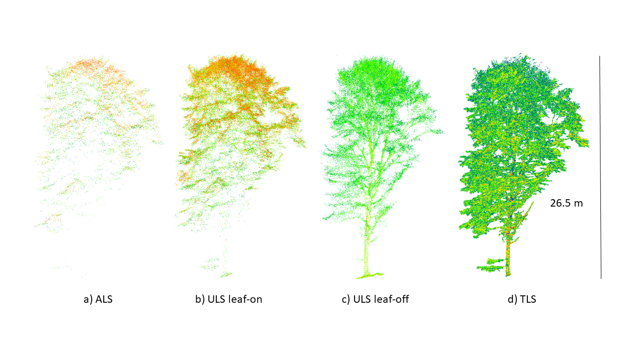
Our final dataset encompasses 1491 trees. For the majority of trees, both ALS and ULS data is available. For 249 trees, point clouds from all three platforms are provided. Besides the larger area and the individual tree point clouds, we also provide the flight trajectories and scan positions, as well as all relevant metadata about the acquisitions and a documentation of our processing workflow.

Within our research project, we are building a database of the individual trees, which we will use to create synthetic 3D forest stands based on 2D forest inventory information. These scenes will be virtually scanned in HELIOS++, the Heidelberg LiDAR Operations Simulator. This way, we can create an abundance of realistic laser scanning datasets of forests with varying sensor configurations, acquisition settings and forest structures. Such simulated point clouds have numerous research applications, such as survey planning, algorithm development and machine learning.

SYSSIFOSS is a joint project between the Institute of Geography and Geoecology (IFGG) of the Karlsruhe Institute of Technology (KIT) and the 3DGeo Research Group of Heidelberg University. The project is funded by the Deutsche Forschungsgemeinschaft (DFG, German Research Foundation) - project number: 411263134. Find further details about the SYSSIFOSS project on the project website, in recent blogposts, or on Twitter (#SYSSIFOSS).

Tags: 3D, 3DGEO, Forestry, Lidar, Open data, PANGAEA, remote sensing, SYSSIFOSS

Posted in 3D, Lidar Group, Publications, Research

Comments are closed.

  • About

    GIScience News Blog
    News of Heidelberg University’s GIScience Research Group.
    There are 1,636 Posts and 0 Comments so far.

  • Meta

    • Log in
    • Entries RSS
    • Comments RSS
    • WordPress.org
  • Recent Posts

    • Leveraging OpenStreetMap and Multimodal Remote Sensing Data with Joint Deep Learning for Wastewater Treatment Plants Detection
    • HGG Vortrag: Heute: Erneuerbare Energien als Entwicklungschance? Deutschland und Kenia im Vergleich. Prof. Klage, 17.05., 19:15 Uhr
    • New “Robert and Christine Danziger PhD Scholarships“ 2022 in Geoinformatics at GIScience Heidelberg University for PhD students from Africa - DL 15.July
    • HGG Vortrag: “Großmacht Russland? Geographien der Transformation im Bereich der ehemaligen Sowjetunion” , Dienstag 10.05.22, 10ct
    • ohsome Region of the month - Back on trail
  • Tags

    3D 3DGEO Big Spatial Data CAP4Access Citizen Science Climate Change crisis mapping Crowdsourcing data quality deep learning disaster DisasterMapping GeoNet.MRN GIScience heigit HOT humanitarian humanitarian mapping Humanitarian OpenStreetMap team intrinsic quality analysis landuse laser scanning Lidar machine-learning Mapathon MapSwipe Missing Maps MissingMaps ohsome ohsome example Open data openrouteservice OpenStreetMap OSM OSM History Analytics Public Health Quality quality analysis remote sensing routing social media spatial analysis Teaching VGI Workshop
  • Archives

    • May 2022
    • April 2022
    • March 2022
    • February 2022
    • January 2022
    • December 2021
    • November 2021
    • October 2021
    • September 2021
    • August 2021
    • July 2021
    • June 2021
    • May 2021
    • April 2021
    • March 2021
    • February 2021
    • January 2021
    • December 2020
    • November 2020
    • October 2020
    • September 2020
    • August 2020
    • July 2020
    • June 2020
    • May 2020
    • April 2020
    • March 2020
    • February 2020
    • January 2020
    • December 2019
    • November 2019
    • October 2019
    • September 2019
    • August 2019
    • July 2019
    • June 2019
    • May 2019
    • April 2019
    • March 2019
    • February 2019
    • January 2019
    • December 2018
    • November 2018
    • October 2018
    • September 2018
    • August 2018
    • July 2018
    • June 2018
    • May 2018
    • April 2018
    • March 2018
    • February 2018
    • January 2018
    • December 2017
    • November 2017
    • October 2017
    • September 2017
    • August 2017
    • July 2017
    • June 2017
    • May 2017
    • April 2017
    • March 2017
    • February 2017
    • January 2017
    • December 2016
    • November 2016
    • October 2016
    • September 2016
    • August 2016
    • July 2016
    • June 2016
    • May 2016
    • April 2016
    • March 2016
    • February 2016
    • January 2016
    • December 2015
    • November 2015
    • October 2015
    • September 2015
    • August 2015
    • July 2015
    • June 2015
    • May 2015
    • April 2015
    • March 2015
    • February 2015
    • January 2015
    • December 2014
    • November 2014
    • October 2014
    • September 2014
    • August 2014
    • July 2014
    • June 2014
    • May 2014
    • April 2014
    • March 2014
    • February 2014
    • January 2014
    • December 2013
    • November 2013
    • October 2013
    • September 2013
    • August 2013
    • July 2013
    • June 2013
    • May 2013
    • April 2013
  •  

    July 2021
    M T W T F S S
    « Jun   Aug »
     1234
    567891011
    12131415161718
    19202122232425
    262728293031  
  • Recent Comments

    GIScience News Blog CC by-nc-sa Some Rights Reserved.

    Free WordPress Themes | Fresh WordPress Themes