• Home
  • About

GIScience News Blog

News of Heidelberg University’s GIScience Research Group.

Feed on
Posts
Comments
« HeiGIT participation at HOT Summit 2021
SocialMedia2Traffic bei Fachaustausch Geoinformation “Smarte Region Rhein-Neckar” »

New Project: GeCO: Generating high-resolution CO2 maps by Machine Learning-based geodata fusion and atmospheric transport modelling

Nov 22nd, 2021 by GIScienceHD

Recently a new project has been starting in the context of Climate Change Action research:

GeCO: Generating high-resolution CO2 maps by Machine Learning-based geodata fusion and atmospheric transport modelling

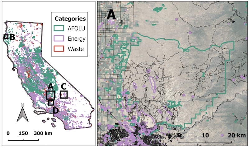
The spatiotemporal distribution of greenhouse gases and their sources on Earth has so far been considered mainly at relatively coarse resolutions. There is a lack of sound information on local emissions and their spatiotemporal distribution. However, these data are urgently needed to design local options for action in climate change mitigation and to validate mitigation efforts.

In the GeCO project, significant progress will be achieved by very high-resolution detection and modeling of the sources of selected greenhouse gases, as well as their turbulent dispersion in the atmosphere. Both the modeling of the distribution of the sources, as well as the dispersion of the gases will be done by means of computer-aided data-intensive methods through collaboration of expertise from environmental physics and geoinformatics. Current methods such as machine learning (ML) and geospatial data fusion are used. The computer computation time is kept low despite the high resolution by using a so-called catalog approach, which enables the dispersion calculation of greenhouse gases over longer time periods despite the high resolution.

Partners from geoinformatics and environmental physics are working in a team on data-driven methods to analyze the sources of greenhouse gases on the Earth’s surface and their turbulent dispersion in the atmosphere. The heterogeneous database for the sources of greenhouse gases on the Earth’s surface consists of diverse sensor readings, citizen science observations, the social web, and official and other statistical data. The discovered patterns are validated by measured values. Machine Learning (ML) methods are used and further developed for the analysis and fusion of the heterogeneous input data and generation of spatially (and temporally) highly resolved emission inventories of relevant greenhouse gases.

The GIScience Research Group (IWR, HCE) develops the methods for data preparation for the emission inventories using methods of Spatial Data Science and ML (esp. deep learning). For this purpose, different geodata sets, in particular on land use and other relevant sources of greenhouse gases (industry, transport, housing, waste, agriculture, etc.) will be analyzed. An important data source is OpenStreetMap (OSM), which contains high-resolution spatial information on buildings, industrial facilities, transport infrastructure and also land use information, which provides the basis for the localization of emissions.
Challenges include the spatially heterogeneous data quality of OSM on the one hand, and the spatially heterogeneous emission factors on the other hand. The question of data quality is investigated and used for the evaluation of the OSM objects.

The team at the Institute of Environmental Physics (IWR, HCE) uses the resulting high-resolution emission maps to set up turbulent dispersion calculations for the dispersion of greenhouse gases in the atmosphere on top of them, and to compare them at the end with in-situ concentration measurements for validation purposes.

Funded by HCE (Heidelberg Center for the Environment): (supported by DFG Initiative of Excellence).
Funding Period: 2021-2023
Principal investigators:
Alexander Zipf, GIScience HD Heidelberg University; Sven Lautenbach (HeiGIT gGmbH).
Sanam Vardag, Institut für Umweltphysik; André Butz, Institut für Umweltphysik; Heidelberg University.

The project builds upon earlier work in the context of the HCE project “Klimahandeln fundiert gestalten, Vergleichende Analyse Ba-Wü / Californien”

Tags: data fusion, deep learning, environment, greenhouse gas emissions, HCE, machine-learning, OpenStreetMap, remote sensing, VGI

Posted in Research

Comments are closed.

  • About

    GIScience News Blog
    News of Heidelberg University’s GIScience Research Group.
    There are 1,676 Posts and 0 Comments so far.

  • Meta

    • Log in
    • Entries RSS
    • Comments RSS
    • WordPress.org
  • Recent Posts

    • GIScience Postdoc/Senior Researcher Opportunity for OpenStreetMap Road Quality Analysis
    • Assessing road criticality and loss of healthcare accessibility during floods: the case of Cyclone Idai, Mozambique 2019
    • New paper on the automatic characterization of surface activities from 4D point clouds
    • OSHDB Version 1.0 Has Arrived
    • Job Opening for Postdoc / Senior Researcher on OpenStreetMap Road Quality Analysis
  • Tags

    3D 3DGEO Big Spatial Data CAP4Access Citizen Science Conference crisis mapping Crowdsourcing data quality deep learning disaster DisasterMapping GeoNet.MRN GIScience heigit HOT humanitarian humanitarian mapping Humanitarian OpenStreetMap team intrinsic quality analysis landuse laser scanning Lidar machine-learning Mapathon MapSwipe MissingMaps Missing Maps ohsome ohsome example Open data openrouteservice OpenStreetMap OSM OSM History Analytics Public Health Quality quality analysis remote sensing routing social media spatial analysis Teaching VGI Workshop
  • Archives

    • January 2023
    • December 2022
    • November 2022
    • October 2022
    • September 2022
    • August 2022
    • July 2022
    • June 2022
    • May 2022
    • April 2022
    • March 2022
    • February 2022
    • January 2022
    • December 2021
    • November 2021
    • October 2021
    • September 2021
    • August 2021
    • July 2021
    • June 2021
    • May 2021
    • April 2021
    • March 2021
    • February 2021
    • January 2021
    • December 2020
    • November 2020
    • October 2020
    • September 2020
    • August 2020
    • July 2020
    • June 2020
    • May 2020
    • April 2020
    • March 2020
    • February 2020
    • January 2020
    • December 2019
    • November 2019
    • October 2019
    • September 2019
    • August 2019
    • July 2019
    • June 2019
    • May 2019
    • April 2019
    • March 2019
    • February 2019
    • January 2019
    • December 2018
    • November 2018
    • October 2018
    • September 2018
    • August 2018
    • July 2018
    • June 2018
    • May 2018
    • April 2018
    • March 2018
    • February 2018
    • January 2018
    • December 2017
    • November 2017
    • October 2017
    • September 2017
    • August 2017
    • July 2017
    • June 2017
    • May 2017
    • April 2017
    • March 2017
    • February 2017
    • January 2017
    • December 2016
    • November 2016
    • October 2016
    • September 2016
    • August 2016
    • July 2016
    • June 2016
    • May 2016
    • April 2016
    • March 2016
    • February 2016
    • January 2016
    • December 2015
    • November 2015
    • October 2015
    • September 2015
    • August 2015
    • July 2015
    • June 2015
    • May 2015
    • April 2015
    • March 2015
    • February 2015
    • January 2015
    • December 2014
    • November 2014
    • October 2014
    • September 2014
    • August 2014
    • July 2014
    • June 2014
    • May 2014
    • April 2014
    • March 2014
    • February 2014
    • January 2014
    • December 2013
    • November 2013
    • October 2013
    • September 2013
    • August 2013
    • July 2013
    • June 2013
    • May 2013
    • April 2013
  •  

    November 2021
    M T W T F S S
    « Oct   Dec »
    1234567
    891011121314
    15161718192021
    22232425262728
    2930  
  • Recent Comments

    GIScience News Blog CC by-nc-sa Some Rights Reserved.

    Free WordPress Themes | Fresh WordPress Themes