
In the context of the United Nations World Data Forum 2021 organised by the United Nations Statistics Division and UN member states a series of blogposts has been published by UNSTATS. Among them is one by Alexander Zipf about improving access to healthcare facilities through geoinformation and crowdsourcing. He introduces the Open Healthcare Access Map by HeiGIT, based on OpenStreetMap (OSM) and openrouteservice (ORS) and further tools and services dealing with OSM data for humanitarian aid like ohsome or the Humanitarian OSM Stats humstats.heigit.org.
For details follow the link or see below:
Improving Access to Healthcare Facilities Through Geoinformation and Crowdsourcing
If the COVID-19 pandemic has taught us anything over the past year, it is how important our healthcare system is. Everyone should have access to a doctor and know how to get to the nearest hospital in an emergency. To help accomplish this, the Heidelberg Institute of Geoinformation Technology (HeiGIT) has developed the Open Healthcare Access Map, a web application that calculates accessibility to healthcare infrastructure by combining traffic data with that infrastructure. Additional information about population distribution provides the user with insights into the health care supply in certain regions. By aggregating the information on an administrative level using hexagons, the Open Healthcare Access Map is able to paint a more accurate picture of the spatial distribution of healthcare in a country on different scales. Though currently a prototype, the application already supports over 80 different countries in various parts of the world.
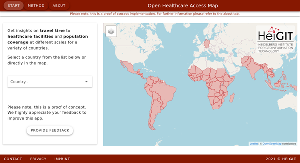
Fig. 1: Overview of all available countries in Open Healthcare Access Map
While OpenStreetMap (OSM) does already offer a lot of data on the healthcare sector, the quality of such data differs in each country. Since OSM is sustained by volunteer mapping efforts, it is important to lower monetary barriers that prevent the emergence of mapping communities in some countries. In 2020, OSM Senegal received a micro-grant and was able to map 197 hospitals in Senegal and update information about the availability of emergency health services at facilities. With this data, users can calculate the impact this information has on emergency services and their capacity through HeiGIT’s openrouteservice, an open source routing service that consumes user-generated and collaboratively collected free geographic data to provide directions in the form of optimized routing and reachability analyses, time-distance matrixes, point-of-interest finding, as well as geocoding. In addition to standard openrouteservice, there are a number of other services provided by HeiGIT that can help improve the lives of people and assist in emergency worker activities. The openrouteservice client for disaster management, for example, is a specialized instance of openrouteservice which provides hourly updates to the road network in disaster areas so that accurate and up-to-date routes can be generated for use in humanitarian relief activities. In addition, HeiGIT’s approach to explore missing built-up areas in OSM using a combination of social and remote sensing, can be used to significantly reduce volunteer mapping efforts and the maintenance of data quality.
Geographic information data is very important for achieving the UN Sustainable Development Goals and needs to be integrated with other data and statistical information. Doing so helps determine to what extent SDGs have been reached and where further action is necessary. This is in line with HeiGIT’s goal of encouraging and facilitating the beneficial use of geoinformation for society. To achieve this goal, HeiGIT (in collaboration with the GIScience group of Heidelberg University) provides a range of in-house developed web services, mostly based on OpenStreetMap (OSM), such as the aforementioned openrouteservice, or the OSM history analytics platform ohsome.org which makes OSM history data more accessible for various data analytics tasks on a global scale. In 2020 HeiGIT was able to provide a new map in ohsomeHeX showing an overview of areas in Sub-Saharan Africa that are still missing vital information on healthcare facilities. Having access to this information is critical for healthcare and emergency workers in order to estimate the need the population may have for these facilities, especially during recurrent waves of the pandemic.
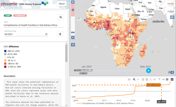
Fig. 2: ohsomeHeX with Completeness layer on Health Facilities in Sub-Sahara Africa
In line with this, the Humanitarian OSM Stats (Humstats) dashboard also provides several humanitarian organizations with detailed, weekly reports on their OSM mapping statistics, allowing them to focus their efforts where it is most needed.
If you are interested in learning more about the various humanitarian and especially healthcare access projects HeiGIT is working on, check out these blogposts:
- All countries of Central and South America now on Open Healthcare Access Map
- Mapping physical access to health care for older adults in sub-Saharan Africa and implications for the COVID-19 response: a cross-sectional analysis
- Updated OSM Healthcare in Senegal (2020)
- Analyzing OSM Completeness of health facilities in Sub-Sahara Africa in ohsomeHeX
- Flood Impact Assessment on Road Network and Healthcare Access at the example of Jakarta, Indonesia
- Exploring OSM for healthcare access analysis in Sub-Saharan Africa
- Recent changes to OpenStreetMap healthcare infrastructure in India
- New Jupyter Notebook: Analysis of Access to Health Care using openrouteservice Isochrones API
- The evolution of humanitarian mapping within the OpenStreetMap community
- Find the route to your nearest Covid-19 vaccination center in Germany — new App by HeiGIT based on OpenStreetMap and openrouteservice
- Accessibility to pharmacies in Germany with 15km Covid-19 restriction
New blogposts are posted on a regular basis on the HeiGIT News site. Would you like to give feedback? Please feel free to reach out via mail. We greatly appreciate it!