
Category: Services
-
GeoPrompt – Revolutionizing Navigation and Beyond: HeiGIT’s Innovative Web Application Powered by ChatGPT
Introduction In an era where technology continuously reshapes our world, the fusion of artificial intelligence and geospatial data offers exciting possibilities. HeiGIT (Heidelberg Institute for Geoinformation Technology), a pioneering research organization, has unveiled a novel web application that not only simplifies navigation but also empowers users to access a wealth of location-based data. This proof-of-concept…
-

Training on digitalization of participatory mapping in Kuala Lumpur
Featured Image: Training participants simulating a participatory mapping on the ground with the SketchMapTool. Last week, HeiGIT team member Anne Schauß held a workshop session in Kuala Lumpur, Malaysia, during a training of the International Federation of Red Cross and Red Crescent Societies (IFRC). The international training focused on community resilience and how to assess…
-
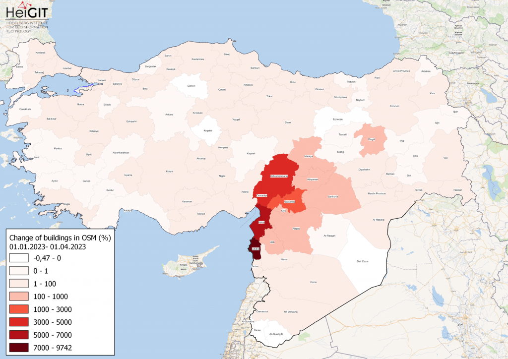
How to become ohsome part 15- Analysing Changes in OSM after the Earthquake in Syria and Türkiye in February 2023
Featured Map: Percent change in each province of Türkiye and Syria of buildings in OSM. Data from OpenStreetMap, visualized using QGIS and the ohsome API plugin. Welcome back to the how to become ohsome series! If you’re new to the series, you can check out the previous issues (like this one) or the ohsome Region of…
-
OSHDB Version 1.0 Has Arrived
Featured Photo: Ohsome dashboard interface for Heidelberg, Germany. In the words of Confucius, “The man who moves a mountain begins by carrying away small stones.” As we release OSHDB (OpenStreetMap History Database) Version 1.0, we look back at versions 0.5, 0.6, 0.7, and all the other small improvements to our historical OpenStreetMap database as the…
-
Time to celebrate! oshdb has reached an object count of >10 billion!
As of 02.11.2022 we have reached objects 10,107,826,483* in our oshdb. As such, we think it is most definitely time to celebrate! *For information on the background this figure, read our Basic guide to OSM data filtering 😉 This blog post is all about reaching 10 billion objects in OpenStreetMap. For the database to aggregate such…
-
Near realtime OpenStreetMap data and stats: OSHDB and ohsome API are now updated hourly
We have exciting ohsome news! As many of you know, past OSHDB updates happened weekly and led to a delay between the data in OpenStreetMap (OSM) and our database. Basically, you had to wait up to a week to see changes in OSM reflected in the OSHDB. From this point forward, that lag is a…
-
ohsome Region of the month – Temporal OSM developments in Kyiv
Welcome back to our ohsome region of the month series! In this post, we’ll take a look at the temporal development of highways and added smoothness-information, as well as social facilities and updates on map development for Kyiv. Before we start, if you’re new to the series, make sure to check out previous installments of…
-
Open Healthcare Access Map Update and HDX
Last year we started the Open Healthcare Access Map. Initially, only a few countries and later on continents were featured. Today, we are pleased to announce that we are releasing a number of previously missing countries, achieving global coverage. The Open Healthcare Access Map uses healthcare facilities extracted from OpenStreetMap, the isochrone method from openrouteservice…
-
Aktivierung des Disaster openrouteservice für Überschwemmungen in Pakistan
In den vergangenen Wochen hat die Monsunflut in Pakistan über 1.000 Tote gefordert und Millionen Menschen ohne Dach über dem Kopf hinterlassen. Da Berichte und Fotos von rapide steigenden Lebensmittelpreisen, Bewohnern, die durch schultertiefes Wasser waten und Satellitenbilder von überfluteten Flüssen das Ausmaß dieser Katastrophe unterstreichen, hat das HeiGIT den Disaster openrouteservice für diese Region…
-
Disaster openrouteservice response to Pakistan flooding
Over the past weeks, monsoon flooding in Pakistan has left over 1,000 dead and millions without homes. As reports and photos of skyrocketing food prices, residents wading through shoulder-deep water, and satellite images of flooded rivers highlight the magnitude of this catastrophe, HeiGIT has created an activation of the Disaster openrouteservice for that region. Currently, data is…
-
New feature addition to Ohsome Quality analysT: Building Completeness Indicator
Introduction Since the release of the ohsome quality analyst (short OQT) in February of last year, we have been working on developing an accessible yet powerful toolkit which provides end users insights on the quality of OpenStreetMap (OSM) data. An overview of the functionality additions made to OQT over this period of time can be found…
-
Gefahrenstellen.de Uses ORS for a Safer Route to School
Creating tools to map and navigate the urban (and not-so-urban) jungle has been a specialty of the HeiGIT and GIScience teams since their founding. We’ve plotted our way to the closest park through meinGrün, fostered awareness of barriers for limited-mobility travelers with CAP4Access, and helped find shortcuts through the unprecedented heat with HEAL. The latest…