
Tag: ohsome example
-
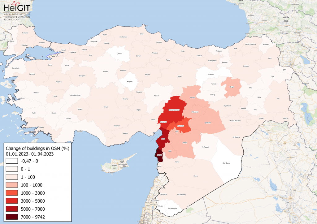
How to become ohsome part 15- Analysing Changes in OSM after the Earthquake in Syria and Türkiye in February 2023
Featured Map: Percent change in each province of Türkiye and Syria of buildings in OSM. Data from OpenStreetMap, visualized using QGIS and the ohsome API plugin. Welcome back to the how to become ohsome series! If you’re new to the series, you can check out the previous issues (like this one) or the ohsome Region of…
-
Time to celebrate! oshdb has reached an object count of >10 billion!
As of 02.11.2022 we have reached objects 10,107,826,483* in our oshdb. As such, we think it is most definitely time to celebrate! *For information on the background this figure, read our Basic guide to OSM data filtering 😉 This blog post is all about reaching 10 billion objects in OpenStreetMap. For the database to aggregate such…
-
Near realtime OpenStreetMap data and stats: OSHDB and ohsome API are now updated hourly
We have exciting ohsome news! As many of you know, past OSHDB updates happened weekly and led to a delay between the data in OpenStreetMap (OSM) and our database. Basically, you had to wait up to a week to see changes in OSM reflected in the OSHDB. From this point forward, that lag is a…
-
ohsome Region of the month – Temporal OSM developments in Kyiv
Welcome back to our ohsome region of the month series! In this post, we’ll take a look at the temporal development of highways and added smoothness-information, as well as social facilities and updates on map development for Kyiv. Before we start, if you’re new to the series, make sure to check out previous installments of…
-
How to become ohsome part 14 – Advanced dashboarding
Hello again and welcome back to our “How to become ohsome” series where we demonstrate how you too can become ohsome with ohsome API! If you’re new to the series or need a refresher, check out the older installments in our series, like this or this one covering the various ways of accessing ohsome API. And now to our…
-
How to become ohsome part 13 – An ohsome way to check if OSM is up to date
At long last, welcome to another addition of our How to become ohsome-series! This one is special because we’re discussing a third-party application that uses ohsome API as back-end to accumulate historical OSM data. Although this innovation isn’t directly about our API, it’s close enough (and exciting enough) to merit inclusion and just one more opportunity for…
-
ohsome Region of the Month: hiking-related tags & mountains
Welcome back to a new installment of the ohsome Region of the Month blog series! This will be part two our posts on hiking related tags and this time, we’ll investigate the connection between user activity and said tags. To do this, we’ll use mountain time as a reference area and incorporate insights from part one…
-
ohsome Region of the month – Back on trail
Welcome back to our Region of the Month series. If you’re hearing about this format the first time you should definitely check out some of our older blog posts, e.g. this one on the tagged forests of different places in Canada or this first part of a street network analysis! Since it’s May and getting warmer again,…
-
ohsome Region of the Month – Mapping of pandemic related facilities
At long last, welcome back to out Region of the Month-series, where we look at different regions in the world and how tags are used there. Today we would like to look at Covid 19 related OpenStreetMap tags in Germany, Austria and Switzerland. More specifically, we would like to look at test stations and vaccination centers and…
-
How to become ohsome part 12 – Using length and area as a predefined filter
Hello and welcome back to part 12 of our “How to become ohsome“-blog post series! If you’re new to this series, check out other blog posts of the series as well, in order to learn how you too, can become ohsome using the ohsome API! This time, we want to take a closer look at the filter options area…
-
How to become ohsome part 11 – counting contributions
Hello and welcome back to the How to become ohsome-blog series! We hope the new year started off well for you! If you’re new to the series, you should read our other posts in the series, as well as the posts in our ohsome Region of the month series, like this one. As already mentioned in part one of the contributions…
-
How to become ohsome part 10 – ohsome holiday contributions
Welcome back to our blog post series How to become ohsome, where you get short and simple explanations on how you can become ohsome yourself! This time, it’s all about our new endpoints, which enable you to track which contributions have been made with respect to a pre-defined region and time period. To explain the usage of…