
Tag: OpenStreetMap
-
GeoNight Mapathon on April 12th
Our next Mapathon is just around the corner, and this time, we’re joining forces with OpenStreetMap Ghana to improve coverage and to help disaster risk assessment.Join us and be a part of the GeoNight 2024 to celebrate geography together in all its forms and facets! Everyone is welcome and no previous knowledge is needed!Do bring your laptop and preferably…
-
IDEAL-VGI: Analyzing and Improving the Quality and Fitness for Purpose of OpenStreetMap as Labels in Remote Sensing Applications
We are happy to announce that the IDEAL-VGI project by GIScience has been successfully completed. IDEAL-VGI was a tandem project in cooperation with Begüm Demir from the TU Berlin and was conducted under the umbrella of the VGIscience Second Phase Projects which ran from 2020 to 2022. VGIscience received funding as a Priority Programme by…
-
Spotlight on HeiGIT’s FOSSGIS 2024 Presentations
We’re thrilled to share some exciting news – our colleagues Julian Psotta and Benjamin Herfort are set to deliver talks at FOSSGIS 2024 in Hamburg, Germany! Julian Psotta will be presenting the openrouteservice project together with the Federal Agency for Cartography and Geodesy (BKG). Their joint talk “From openrouteservice to RoutingPlus – Insights into a…
-
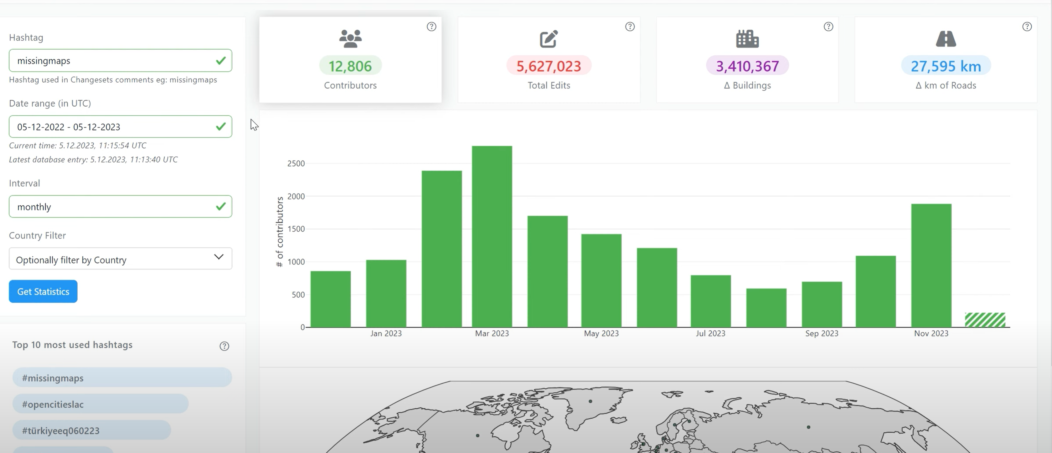
Introducing OhsomeNowStats
OhsomeNowStats allows users to take a look at the mapping activity in OpenStreetMap. This is especially useful for humanitarian organizations and mapathon organizers, because OhsomeNowStats data is updated every 5-10 minutes. Using this tool, user-engagement can be tracked in near real time and used to motivate participants and volunteers alike! By selecting a time range,…
-
HeiGIT-Team Wins “Open Source Software for Sustainable Development Goals (OSS4SDG)” Hackathon
The HeiGIT team recently secured the top position in the third edition of the Open Source Software for Sustainable Development Goals (OSS4SDG) hackathon. These hackathons are based on the 17 Sustainable Development Goals (SDGs) of the UN. The participants were tasked to take on one of seven challenges, each with the goal to develop and…
-
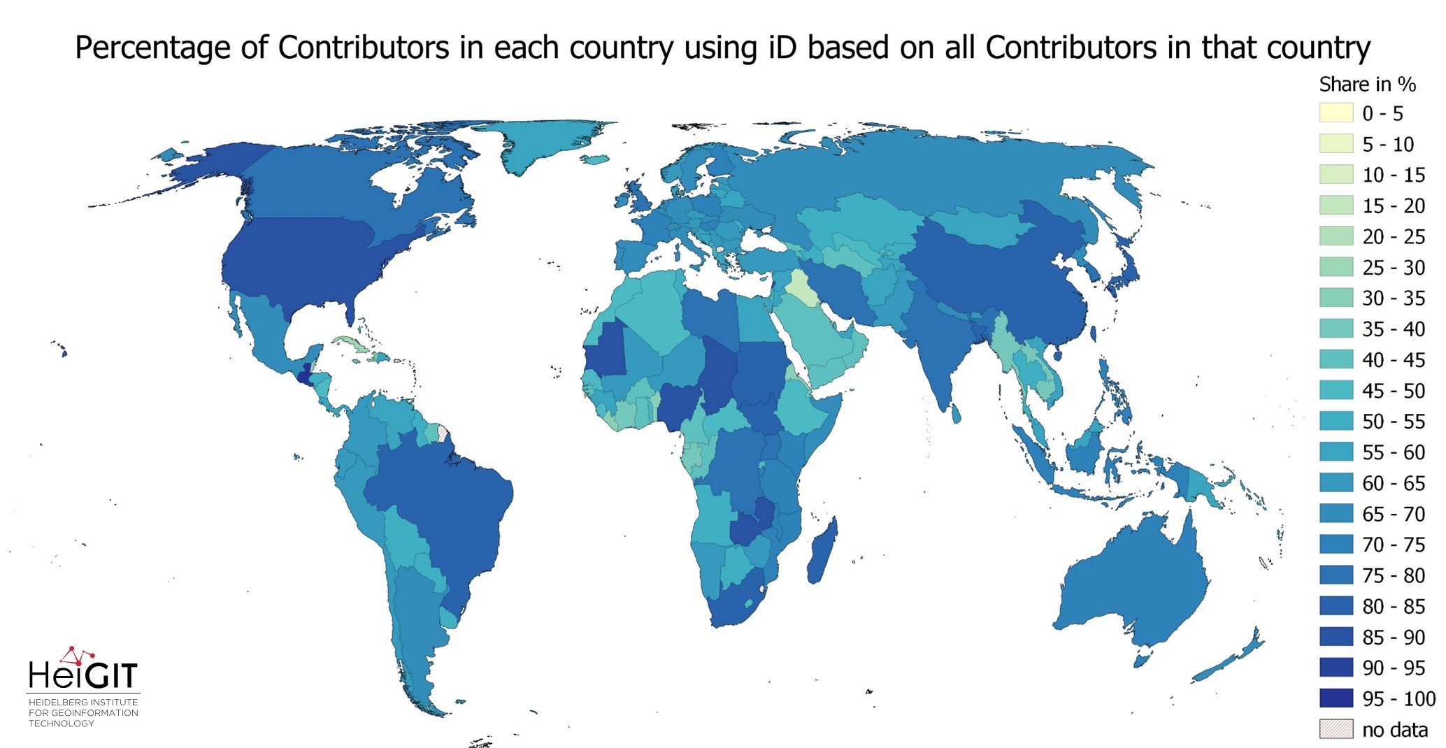
Exploring OSM editor statistics by combining data from OSHDB and changeset DB
OpenStreetMap (OSM) marks one of the most successful and powerful open source, crowdsourced geomaps, with over 10 million registered users by 2023. Since 2008 this number has increased steadily. In this blog post we want to look behind this success from the perspective of editing software used to add, modify and delete data in OSM.…
-
Integration of OQT into the ohsome dashboard: Computing data quality metrics for OpenStreetMap
The ohsome dashboard has been and continues to be an easy access point to generate accurate statistics about the historical development of OpenStreetMap data for arbitrary regions. Now, the ohsome dashboard got extended to be able to compute data quality metrics for OpenStreetMap through the ohsome quality analyst (OQT) which is also developed by HeiGIT. The source code is now…
-
Unleashing the Power of AI-Assisted Mapping in OpenStreetMap? – a webinar with HOT and Masaryk University
The ever-increasing volume and speed of corporate or machine learning-assisted mapping present unique challenges for individual volunteer mappers, particularly in terms of monitoring and validation. While the global impact and evolution of AI-assisted mapping in OpenStreetMap (OSM) remain largely unknown, there is a need to engage with mappers to understand their perspectives on this emerging…
-
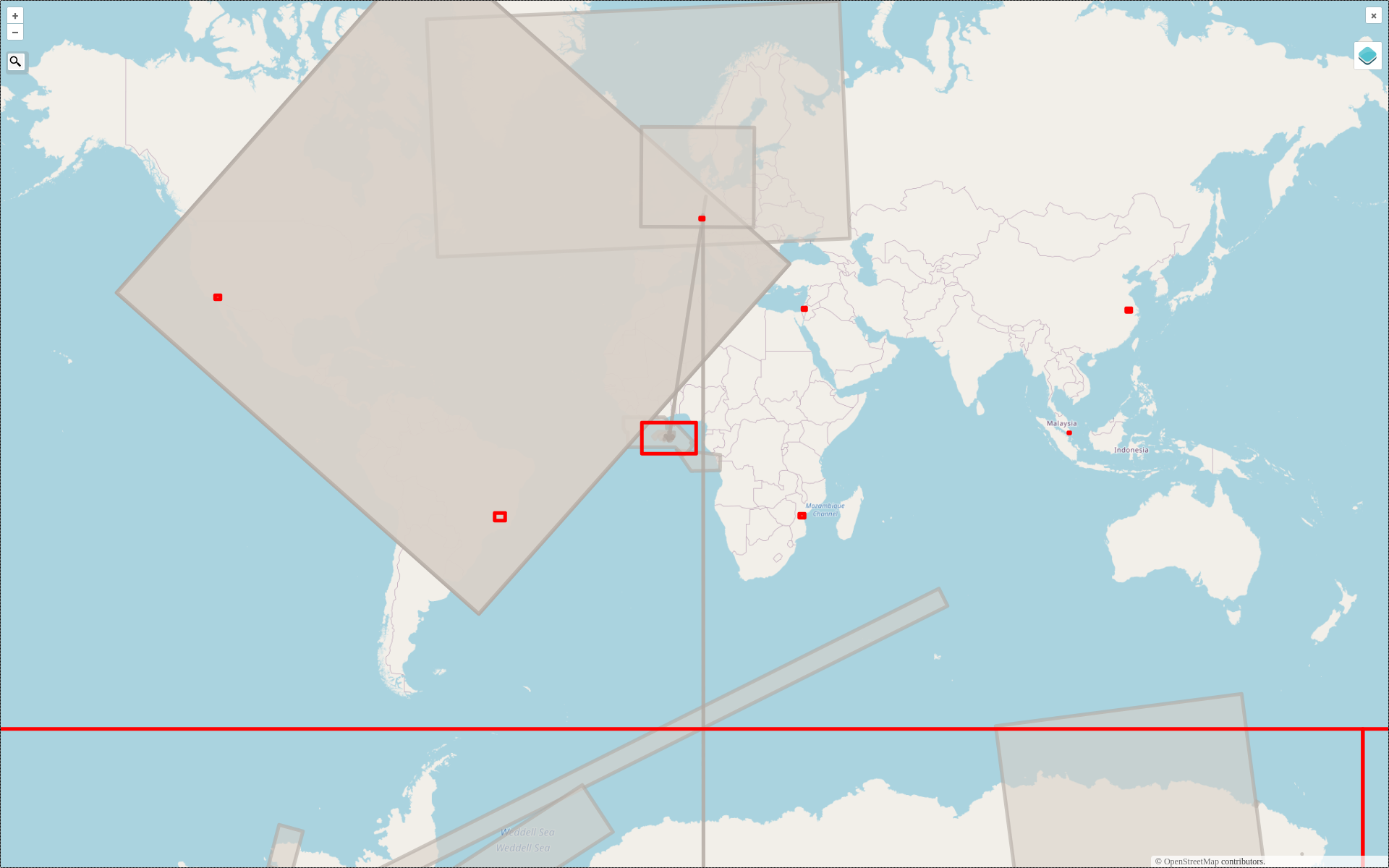
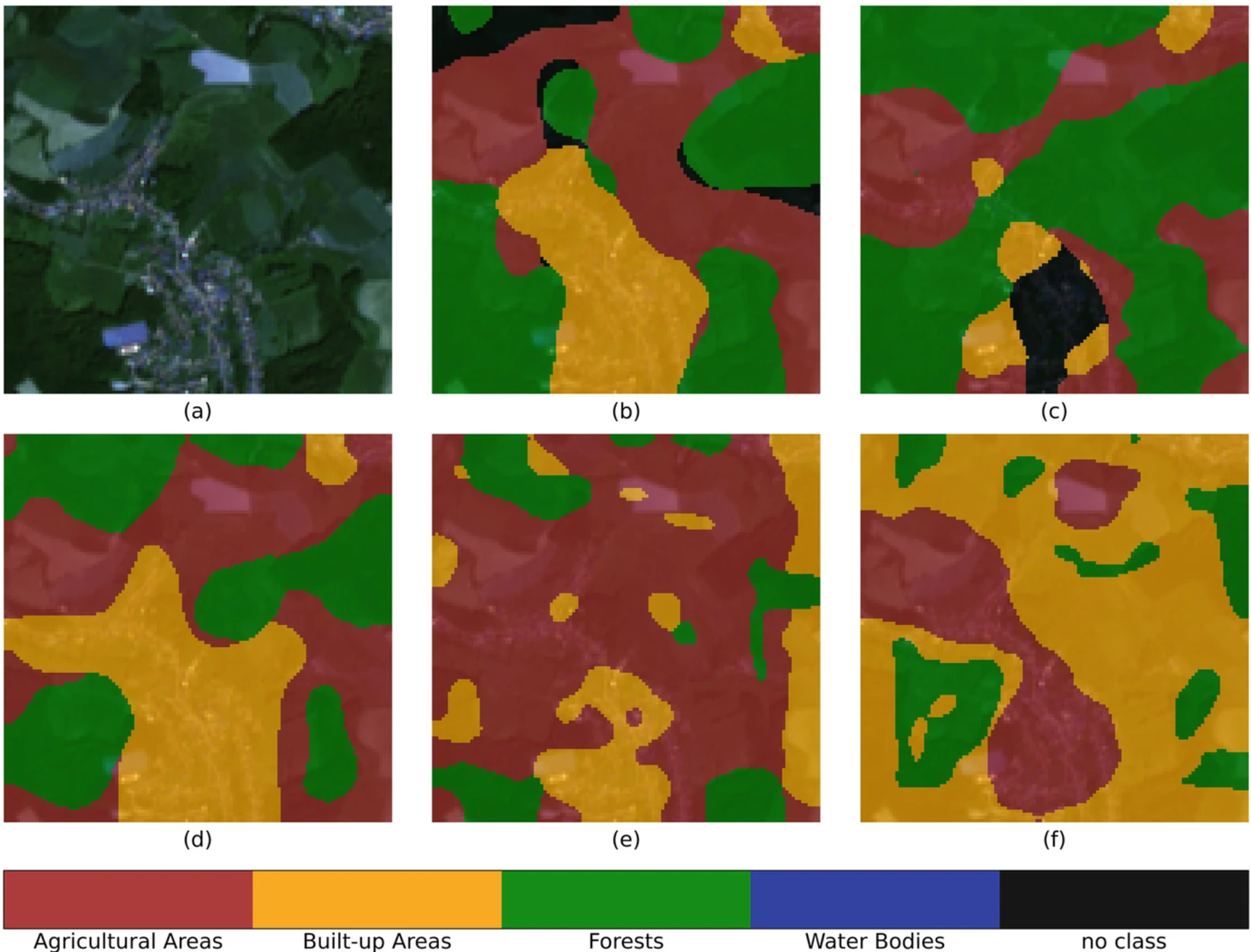
2022 #30DayMapChallenge Round-Up Part 2: Deleted Maps
Featured photo: The deleted map displays all deleted elements within the analyzed areas (red). Gray rectangles represent deleted buildings. This past November, our teams at HeiGIT and GIScience participated in Topi Tjukanov’s Twitter event #30DayMapChallenge, where mappers display their creativity and ingenuity with a set of 30 daily prompts ranging from colors to specific datasets…
-
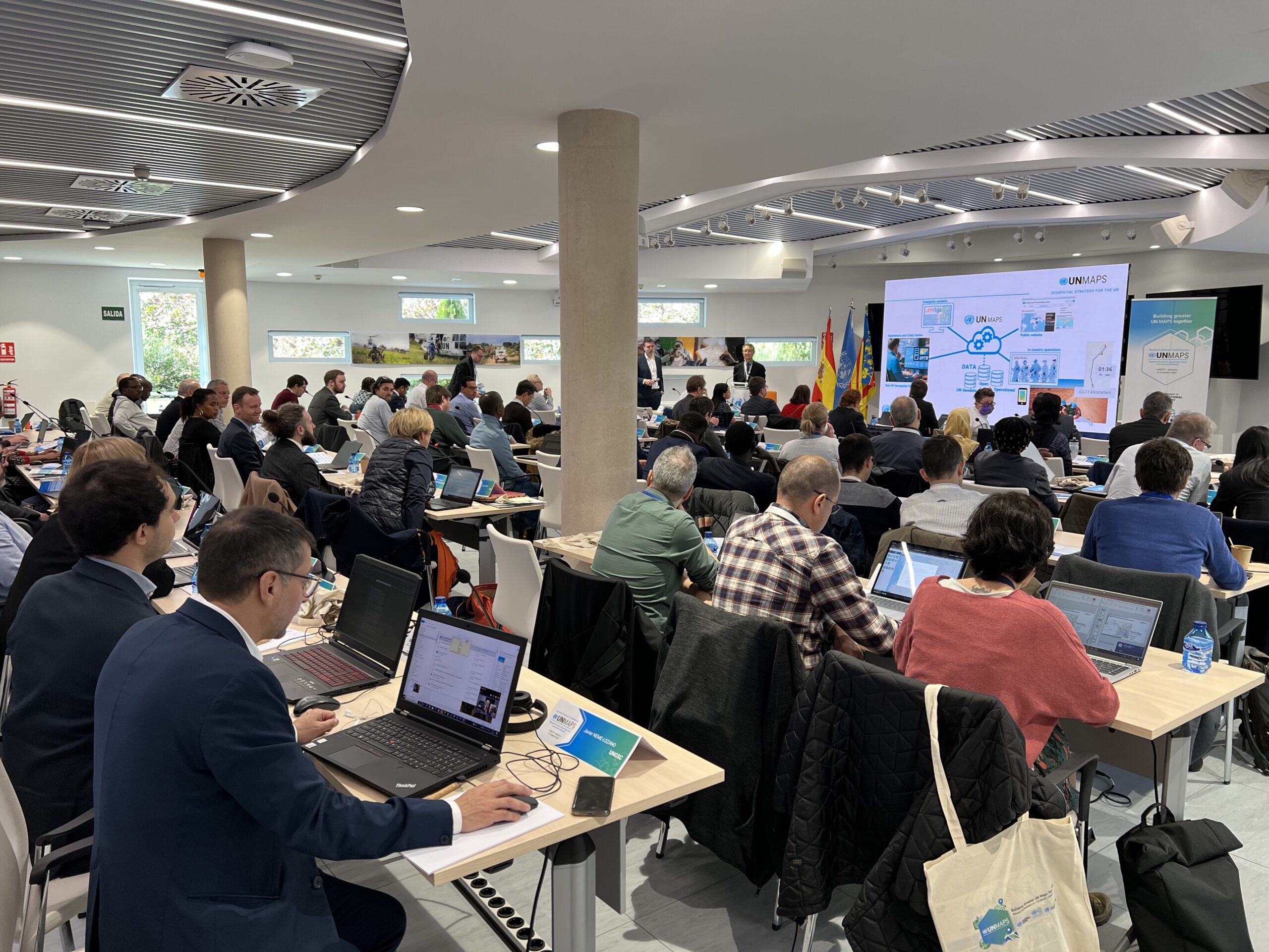
HeiGIT’s contributions to the 2nd UN Maps Conference
The United Nations Maps program, created in 2019, held its 2nd UN Maps Conference, this time in Valencia, Spain. Prof. Alexander Zipf of HeiGIT and the GIScience Research Group at Heidelberg University and Benjamin Herfort of HeiGIT attended the conference to talk about “Open Ecosystems in Practice”, “Partnerships and Cooperation with Academia” and how to “build better…
-
Activation of the Disaster Portal for the earthquake in Türkiye/Syria
During catastrophic events such as the recent Türkiye/Syria earthquake, the road infrastructure in the affected area is often widely interrupted and accessibility varies over time. Inspite of this, it is imperative to quickly provide assistance to the affected people. Humanitarian Organizations need real-time information for force and logistics planning: Which roads are still passable? How…
-
Access to safe abortion in Germany
Our team thoroughly enjoyed the newly in-person State of the Map 2022 in Florence. We attended workshops, talks, and had the opportunity to present our own poster about the accessibility of abortion clinics in Germany, which will be discussed in this post and can be found here. In the following blog, we’ll explore more information…