
Tag: OSM
-
HeiGITs Disaster Portal in Radiobeitrag vorgestellt
Campusreporter Nils Birschmann hat mit Prof. Alexander Zipf über unser Disaster Portal gesprochen. Das Interview wurde über Radio Regenbogen ausgestrahlt. Hier könnt ihr euch den Beitrag in voller Länge anhören: Audiobeitrag: Das Disaster Portal – sichere und schnell verfügbare Datengrundlagen im Katastrophenfall Darum geht’s: Im Katastrophenfall sind Hilfskräfte auf aktuelle Ortsdaten der betroffenen Region angewiesen: Welche…
-
Bachelor’s thesis: Using OSM for location analyses of residential real estate projects – an extrinsic analysis of data quality
In his bachelor’s thesis, supervised by HeiGIT’s apl. Prof. Dr. Sven Lautenbach, Lars Reckhaus examined the suitability of OpenStreetMap (OSM) for location analyses in the context of residential real estate projects. Typically, such analyses require the use of a variety of data sources and are mostly performed manually. For this reason, they tend to be…
-

Introducing ohsomeNow stats: Real-Time Monitoring for OpenStreetMap Contributions
You can now monitor contributions to OpenStreetMap (OSM) in real time with ohsomeNow stats! We developed this new dashboard as part of our long-term cooperation with the Humanitarian OpenStreetMap Team (HOT), an international organization dedicated to humanitarian action and community development through open mapping. This dashboard replaces the Missing Maps Leaderboard with a comprehensive overview of…
-
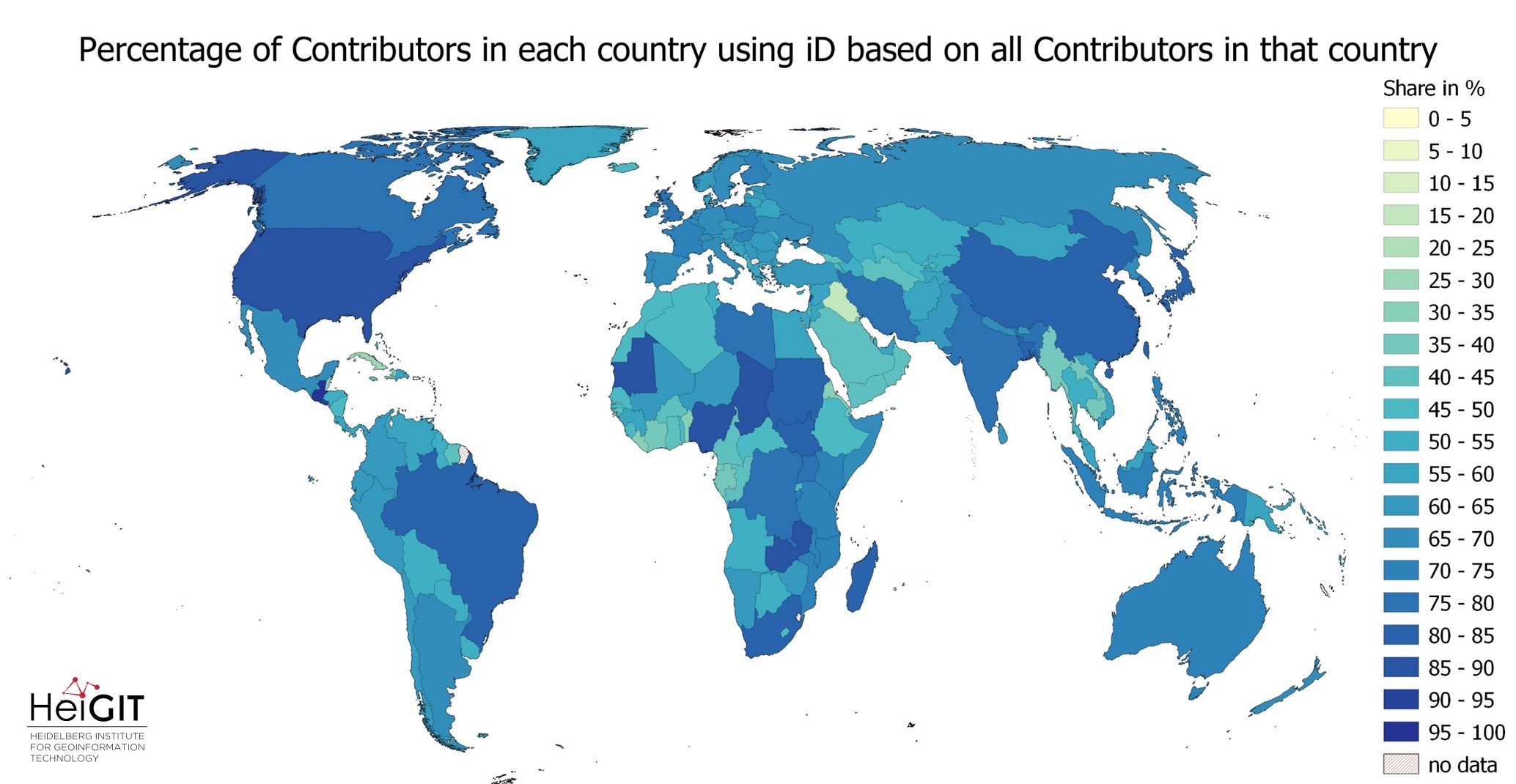
Exploring OSM editor statistics by combining data from OSHDB and changeset DB
OpenStreetMap (OSM) marks one of the most successful and powerful open source, crowdsourced geomaps, with over 10 million registered users by 2023. Since 2008 this number has increased steadily. In this blog post we want to look behind this success from the perspective of editing software used to add, modify and delete data in OSM.…
-
HeiGIT at Summer School Disaster Risk Reduction 2023
Today we’d like to tell you about the Summer School Disaster Risk Reduction 2023 event hosted by the Environmental Campus of UAS Trier in Germany and organized by the German Committee for Disaster Reduction (DKKV). During this one-week course that took place from the 9th till the 15th of July 2023, students and people interested…
-
New Publication in “Nature Communication” on the unequal distribution of building data in OSM
Benjamin Herfort and his colleagues Sven Lautenbach, João Porto de Albuquerque, Jennings Anderson and Alexander Zipf published an article in the renowned journal Nature Communications (Impact Factor 2023: 17.7). In their article, they address the uneven distribution of OpenStreetMap data worldwide, which can have an impact on research results and humanitarian operations. They provide solutions…
-
OEV: Indicator Correlations (4/4)
After introducing the OSM Element Vectorisation Tool last week, we now want to show possible use cases and specific examples of what the tool can do. This third and last example will look at the correlations between indicators. The goal is to first assure that the indicators measure distinct data attributes and then search for interesting or…
-
OEV: Quantifying differences between imports (3/4)
After introducing the OSM Element Vectorisation Tool last week, we now want to show possible use cases and specific examples of what the tool can do. This second of three use cases (see use case 1) compares the data in the regions of Maribor, Slovenia and Ngaoundéré, Cameroon. Both regions are exceptionally well covered with land-use and land-cover information in OSM.…
-
OEV: Analysing attributes of remarkable elements (2/4)
After introducing the OSM Element Vectorisation Tool earlier this week, we now want to show possible use cases and specific examples of what the tool can do. This first of three use cases takes a closer look at the data in the region of Heidelberg, Germany. We will use the concept of archetypes to identify…
-
OSM Element Vectorisation Tool Version 1
The IDEAL-VGI research project is nearing its end. And while that won’t be the end of our research into social data sources, data quality analyses and land-use information, we are happy to announce a major outcome: the version 1 release of the OSM Element Vectorisation Tool (OEV). The tool was first presented to the public…
-
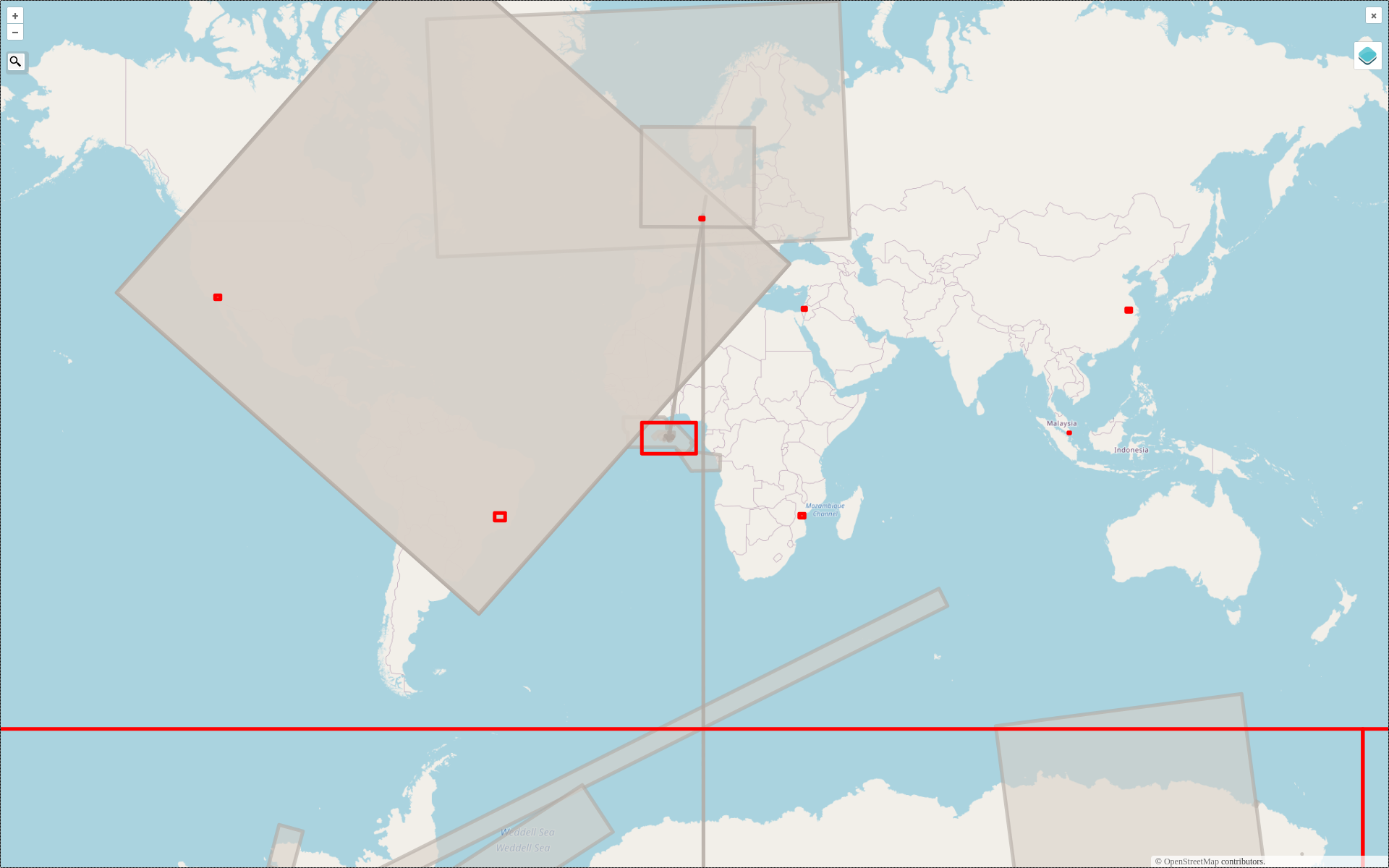
2022 #30DayMapChallenge Round-Up Part 2: Deleted Maps
Featured photo: The deleted map displays all deleted elements within the analyzed areas (red). Gray rectangles represent deleted buildings. This past November, our teams at HeiGIT and GIScience participated in Topi Tjukanov’s Twitter event #30DayMapChallenge, where mappers display their creativity and ingenuity with a set of 30 daily prompts ranging from colors to specific datasets…
-
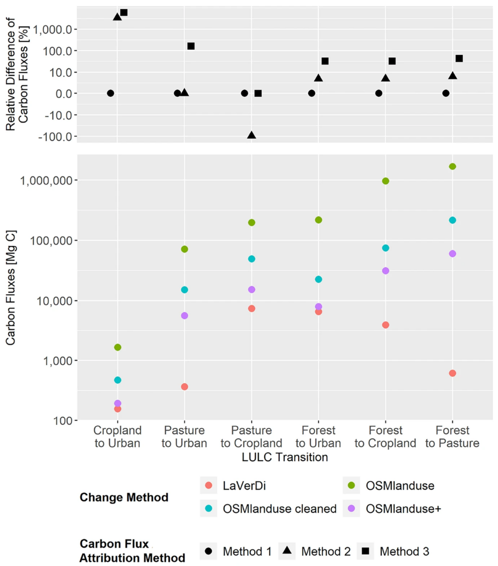
New Paper: Carbon Fluxes Related to Land Use and Land Cover Change in Baden-Württemberg
Featured Image: Figure 1. Total carbon fluxes related to LULCC in Baden-Württemberg between March 2018 and October 2019 (LaVerDi, OSMlanduse+), and March 2018 and March 2020 (OSMlanduse, OSMlanduse cleaned). The upper plot shows the relative difference of carbon fluxes [%] with respect to LULC transition and carbon flux attribution method. The carbon fluxes of method…