
Tag: OSM
-
Private Vehicles Greenhouse Gas Emission Estimation at Street Level for Berlin Based on Open Data
Since the transportation sector is one of the major greenhouse gas (GHG) emitters that has not seen significant emission reductions in the last decades, it requires special attention from policymakers. However, estimations of traffic emissions often rely on huge amounts of actual traffic data whose availability is limited. Therefore, Ulrich et al. now propose an…
-
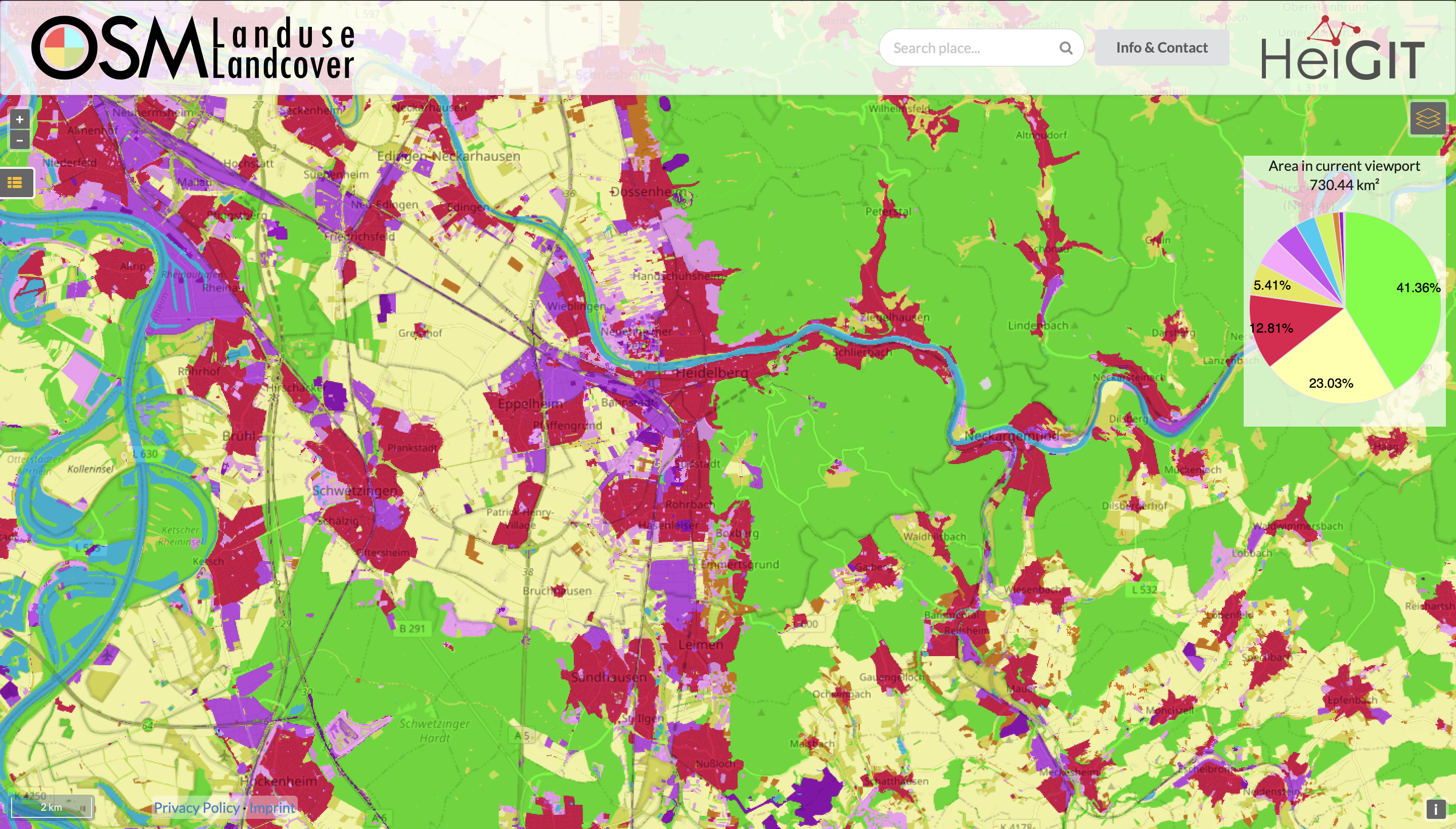
Functionality Update for OSM Landuse Landcover
We are pleased to announce that https://osmlanduse.org has received a functionality update. Thanks to the cooperation of GIScience and HeiGIT under the IDEAL-VGI project, our researchers were able to add a number of new features to the interactive map. The map displays OSM land-use and land-cover information. The two different data layers that made up…
-
Activation of the Disaster Portal for the earthquake in Türkiye/Syria
During catastrophic events such as the recent Türkiye/Syria earthquake, the road infrastructure in the affected area is often widely interrupted and accessibility varies over time. Inspite of this, it is imperative to quickly provide assistance to the affected people. Humanitarian Organizations need real-time information for force and logistics planning: Which roads are still passable? How…
-
GIScience Postdoc/Senior Researcher Opportunity for OpenStreetMap Road Quality Analysis
If you’re on the job market or know someone who is, check out this exciting new opening from our partners at GIScience. The offer is included as text below. You are interested in enhancing methods for analyzing & improving OpenStreetMap data? You are an experienced Spatial Data Scientist innovating geoinformatics methods & workflows? You have…
-
OSHDB Version 1.0 Has Arrived
Featured Photo: Ohsome dashboard interface for Heidelberg, Germany. In the words of Confucius, “The man who moves a mountain begins by carrying away small stones.” As we release OSHDB (OpenStreetMap History Database) Version 1.0, we look back at versions 0.5, 0.6, 0.7, and all the other small improvements to our historical OpenStreetMap database as the…
-
Job Opening for Postdoc / Senior Researcher on OpenStreetMap Road Quality Analysis
If you’re on the job market or know someone who is, check out this exciting new opening at GIScience. The offer is included as text below! You are interested in enhancing methods for analyzing & improving OpenStreetMap data? You are an experienced Spatial Data Scientist innovating geoinformatics methods & workflows? You have profound hands-on experience…
-
Time to celebrate! oshdb has reached an object count of >10 billion!
As of 02.11.2022 we have reached objects 10,107,826,483* in our oshdb. As such, we think it is most definitely time to celebrate! *For information on the background this figure, read our Basic guide to OSM data filtering 😉 This blog post is all about reaching 10 billion objects in OpenStreetMap. For the database to aggregate such…
-
Near realtime OpenStreetMap data and stats: OSHDB and ohsome API are now updated hourly
We have exciting ohsome news! As many of you know, past OSHDB updates happened weekly and led to a delay between the data in OpenStreetMap (OSM) and our database. Basically, you had to wait up to a week to see changes in OSM reflected in the OSHDB. From this point forward, that lag is a…
-
ohsome Region of the month – Temporal OSM developments in Kyiv
Welcome back to our ohsome region of the month series! In this post, we’ll take a look at the temporal development of highways and added smoothness-information, as well as social facilities and updates on map development for Kyiv. Before we start, if you’re new to the series, make sure to check out previous installments of…
-
New feature addition to Ohsome Quality analysT: Building Completeness Indicator
Introduction Since the release of the ohsome quality analyst (short OQT) in February of last year, we have been working on developing an accessible yet powerful toolkit which provides end users insights on the quality of OpenStreetMap (OSM) data. An overview of the functionality additions made to OQT over this period of time can be found…
-
Gefahrenstellen.de Uses ORS for a Safer Route to School
Creating tools to map and navigate the urban (and not-so-urban) jungle has been a specialty of the HeiGIT and GIScience teams since their founding. We’ve plotted our way to the closest park through meinGrün, fostered awareness of barriers for limited-mobility travelers with CAP4Access, and helped find shortcuts through the unprecedented heat with HEAL. The latest…
-
How to become ohsome part 14 – Advanced dashboarding
Hello again and welcome back to our “How to become ohsome” series where we demonstrate how you too can become ohsome with ohsome API! If you’re new to the series or need a refresher, check out the older installments in our series, like this or this one covering the various ways of accessing ohsome API. And now to our…