
Tag: routing
-
Unveiling the Impact of School Commutes: Charles Hatfield Presents Insights on Traffic Congestion and Urban Planning at ATRC 2024
Charles Hatfield will represent HeiGIT at the first ever African Transport Research Conference (ATRC 2024) which takes place from March 5-7 in Capetown, South Afrika. The conference was established to address rapid urbanisation in Africa and the corresponding challenges for transport and infrastructure. Volvo Research and Educational Foundations (VREF) and the Centre for Transport Studies…
-
GeoPrompt – Revolutionizing Navigation and Beyond: HeiGIT’s Innovative Web Application Powered by ChatGPT
Introduction In an era where technology continuously reshapes our world, the fusion of artificial intelligence and geospatial data offers exciting possibilities. HeiGIT (Heidelberg Institute for Geoinformation Technology), a pioneering research organization, has unveiled a novel web application that not only simplifies navigation but also empowers users to access a wealth of location-based data. This proof-of-concept…
-
HeiGIT-Team Wins “Open Source Software for Sustainable Development Goals (OSS4SDG)” Hackathon
The HeiGIT team recently secured the top position in the third edition of the Open Source Software for Sustainable Development Goals (OSS4SDG) hackathon. These hackathons are based on the 17 Sustainable Development Goals (SDGs) of the UN. The participants were tasked to take on one of seven challenges, each with the goal to develop and…
-
Activation of the Disaster Portal for the earthquake in Türkiye/Syria
During catastrophic events such as the recent Türkiye/Syria earthquake, the road infrastructure in the affected area is often widely interrupted and accessibility varies over time. Inspite of this, it is imperative to quickly provide assistance to the affected people. Humanitarian Organizations need real-time information for force and logistics planning: Which roads are still passable? How…
-
Disaster openrouteservice to support the current response efforts to the Türkiye/Syria earthquake
On February 6, a 7.7 magnitude earthquake struck southern Türkiye at 4:17 a.m. This is Türkiye’s most powerful earthquake recorded since 1939. The Government of Türkiye has since issued a Level 4 alarm, calling for international assistance. The quake also heavily impacted north-west Syria, a region where 4.1 million people depend on humanitarian assistance already…
-
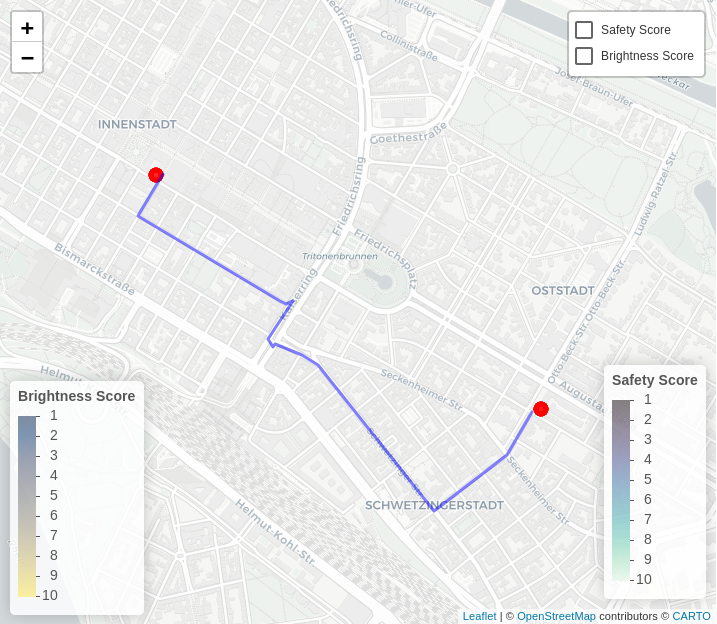
Gefahrenstellen.de Uses ORS for a Safer Route to School
Creating tools to map and navigate the urban (and not-so-urban) jungle has been a specialty of the HeiGIT and GIScience teams since their founding. We’ve plotted our way to the closest park through meinGrün, fostered awareness of barriers for limited-mobility travelers with CAP4Access, and helped find shortcuts through the unprecedented heat with HEAL. The latest…
-
meinGrün, Tardur und SocialMedia2Traffic bei der mFUND Konferenz 2021
Letzte Woche konnten wir bei der digitalen mFUND Konferenz drei unserer Projekte einem interessierten Publikum vorstellen. Im Fachforum “Die „15-Minuten-Stadt“ datenbasiert ermöglichen” haben wir gezeigt, wie die meinGrün App, das meinGrün Webportal und die angegliederten Dienste Städte dabei unterstützen könnten, die Erreichbarkeit von öffentlichen Grünflächen zu verbessern. Dabei zeigten sich auch Anknüpfungspunkte zu weiteren mFUND…
-
WENN ES IN DER STADT ZU HEISS WIRD
Aktuelle Meldung der Universität Heidelberg zum Projekt HEAL: https://www.uni-heidelberg.de/de/newsroom/wenn-es-in-der-stadt-zu-heiss-wird BADEN-WÜRTTEMBERG STIFTUNG FÖRDERT HEIDELBERGER PROJEKT ZU ROUTINGDIENST MIT HITZEVERMEIDENDEN WEGSTRECKEN Wo in der Stadt Heidelberg ist es besonders heiß und wie wirken sich lokale Hitzebelastungen auf gefährdete Personengruppen aus? Mit dieser Frage befasst sich ein Forschungsprojekt, durchgeführt von der Abteilung Geoinformatik und dem TdLab Geographie am Geographischen…
-
A Web App to generate and disseminate knowledge on urban green space qualities and their accessibility
Urban green spaces (UGSs) can provide important ecosystem services for citizens and their well-being. To make use of these services according to UGS user demands, urban residents, tourists, and city administrations should know where UGSs are located, what qualities they have and how to reach them on convenient routes. A new open access paper at…
-
Revamped openrouteservice client for disaster management
We are happy to announce a revamped openrouteservice maps client for disaster management. It was built based on the new openrouteservice maps client, that is an open source route planner with plenty of features. Specific disaster features were incorporated via the development of developing plugins. It was developed and is maintained by the Heidelberg Institute for…
-
Routenplanung im Überflutungsgebiet: openrouteservice nutzt Copernicus EMS Flut-Daten in spezieller Lösung
Die aktuelle Flut in Deutschland hat zahlreiche Straßen in den betroffenen Gebieten zerstört oder temporär unpassierbar gemacht. HeiGIT arbeitet an freien und offenen, auf Geodaten-basierten Lösungen für die humanitäre Hilfe. Hierzu zählen insbesondere Routenplanung unter Berücksichtigung aktueller Katastrophendaten wie z.B. Überflutungsgebiete und zerstörter Strassen. Für die aktuelle Flutkatastrophe in Deutschland und Nachbarstaaten hat HeiGIT nun…
-
A safe way through the heat: Transdisciplinary project HEAL makes everyday life easier for at-risk groups
(in Deutsch unterhalb) Aerial view of Heidelberg’s old town with the university square. This was a site of the study on climate change adaptation of public spaces (Foshag et al. 2020). (Photo: Kathrin Foshag). As part of a transdisciplinary collaboration, the Heidelberg Institute for Geoinformation Technology (HeiGIT), the GIScience research group and the TdLab Geography at…