• Home
  • About

GIScience News Blog

News of Heidelberg University’s GIScience Research Group.

Feed on
Posts
Comments
« SYSSIFOSS project video on the potential of synthetic LiDAR data in forestry applications
OSM completeness mapping for airborne situation assessment following an earthquake »

ohsome API v1.1 - changes and new functionalities

Sep 14th, 2020 by Fabian Kowatsch

Recently we’ve had the first minor release 1.1 of the ohsome API, which brings several new features and upgrades. In the following lines we want to present to you the most important ones.

Prior to 1.1, when you were requesting data through one of our data extraction endpoints, you would always get the geometries clipped to the given spatial boundary|boundaries. With the addition of the parameter clipGeometry, you can now specify by yourself if you want to get them clipped (clipGeometry=true) or unclipped (clipGeometry=false). The default behavior is having clipping of the features enabled, as we want to ensure backwards compatibility. To demonstrate a use case we’ve prepared an example request where we take a look at the buildings within a 2km catchment area of the football stadium of TSG Hoffenheim in Sinsheim. The graphic shows the buildings with an unclipped geometry in purple overlayed with the clipped features in orange.

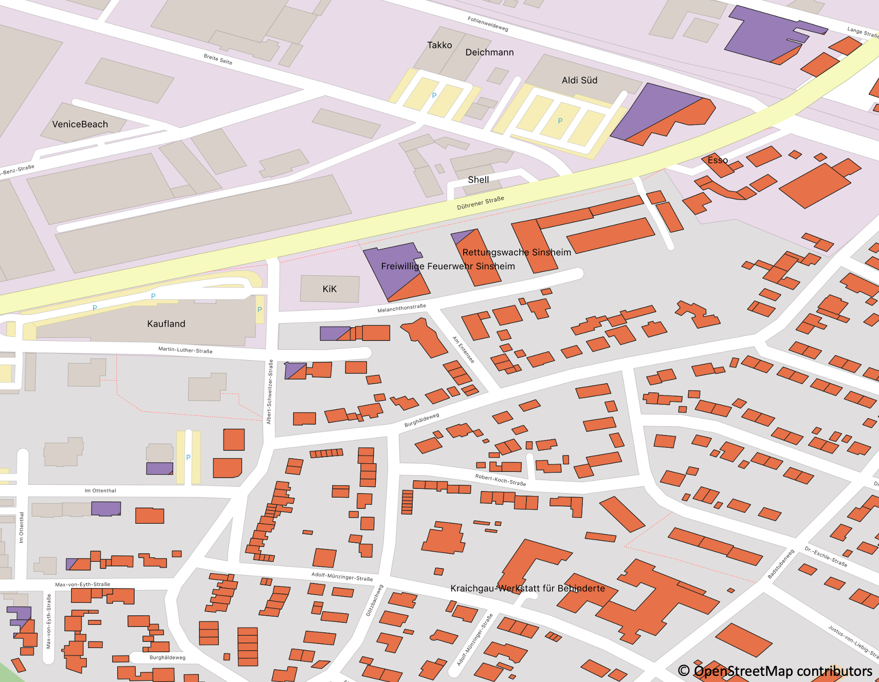
You can clearly see the cut of the boundary through the buildings. Using clipped geometries could make sense if someone is computing aggregations of the features in the given region, e.g. to get the length of the road network. When extracting and visualizing data, like in the given example, it is better though to disable the clipping. Here are the example URLs of clipped vs. unclipped.

The second new feature comes along with an upgrade of the ohsome filter library to 1.2 bringing the following two new filter functionalities:

  • having a “tag key in value-list” operator to select a specific set of tags having the same key
    • filter example: filter=highway in (residential, living_street)
    • request example: give the length of residential and living streets (URL)
  • selecting features by their OSM ID, either through giving one particular ID, a list of IDs or a range of IDs; it should always be combined with an OSM type
    • filter examples: filter=type:way and id:12345   filter=type:reladion and id:(1, 2, 3)   filter=type:way and id:(1 .. 123)
    • request example: select one specific OSM feature (URL)

Of course these new filters are also documented within the dedicated filter documentation page.

Apart from these changes, there have been a few updates on the GitHub readme, as well as stuff that only affects the code itself, like the increase of the Java compatibility to version 11 or diverse smaller bug fixes and code refactorings. The full list of changes can be found in the changelog of the ohsome API GitHub repository. Have fun with using the new features and remember: stay ohsome!

Context: the aim of the ohsome OpenStreetMap History Data Analytics Platform is to make OpenStreetMap’s full-history data more easily accessible for various kinds of OSM data analytics tasks, such as data quality analysis, on a global scale. The ohsome API is one of its components, providing free and easy access to some of the functionalities of the ohsome platform via HTTP requests. Some intro can be found here:

  • ohsome general idea
  • ohsome general architecture
  • the whole “how to become ohsome” tutorials series
  • how to make a query
  • integration of simple feature keywords in the filters of the ohsome API.
  • how spatial joins queries work in the OpenStreetMap History Database OSHDB

Tags: Big Spatial Data, heigit, intrinsic quality analysis, ohsome, Open Source, OSM, OSM History Analytics

Posted in OSM, Services, Software

Comments are closed.

  • About

    GIScience News Blog
    News of Heidelberg University’s GIScience Research Group.
    There are 1,674 Posts and 0 Comments so far.

  • Meta

    • Log in
    • Entries RSS
    • Comments RSS
    • WordPress.org
  • Recent Posts

    • New paper on the automatic characterization of surface activities from 4D point clouds
    • OSHDB Version 1.0 Has Arrived
    • Job Opening for Postdoc / Senior Researcher on OpenStreetMap Road Quality Analysis
    • Geography Awareness Week 14.-19.11.2022
    • Open Data: Multi-platform point clouds and orthophotos of the inland dune in Sandhausen
  • Tags

    3D 3DGEO Big Spatial Data CAP4Access Citizen Science Conference crisis mapping Crowdsourcing data quality deep learning disaster DisasterMapping GeoNet.MRN GIScience heigit HOT humanitarian humanitarian mapping Humanitarian OpenStreetMap team intrinsic quality analysis landuse laser scanning Lidar machine-learning Mapathon MapSwipe MissingMaps Missing Maps ohsome ohsome example Open data openrouteservice OpenStreetMap OSM OSM History Analytics Public Health Quality quality analysis remote sensing routing social media spatial analysis Teaching VGI Workshop
  • Archives

    • December 2022
    • November 2022
    • October 2022
    • September 2022
    • August 2022
    • July 2022
    • June 2022
    • May 2022
    • April 2022
    • March 2022
    • February 2022
    • January 2022
    • December 2021
    • November 2021
    • October 2021
    • September 2021
    • August 2021
    • July 2021
    • June 2021
    • May 2021
    • April 2021
    • March 2021
    • February 2021
    • January 2021
    • December 2020
    • November 2020
    • October 2020
    • September 2020
    • August 2020
    • July 2020
    • June 2020
    • May 2020
    • April 2020
    • March 2020
    • February 2020
    • January 2020
    • December 2019
    • November 2019
    • October 2019
    • September 2019
    • August 2019
    • July 2019
    • June 2019
    • May 2019
    • April 2019
    • March 2019
    • February 2019
    • January 2019
    • December 2018
    • November 2018
    • October 2018
    • September 2018
    • August 2018
    • July 2018
    • June 2018
    • May 2018
    • April 2018
    • March 2018
    • February 2018
    • January 2018
    • December 2017
    • November 2017
    • October 2017
    • September 2017
    • August 2017
    • July 2017
    • June 2017
    • May 2017
    • April 2017
    • March 2017
    • February 2017
    • January 2017
    • December 2016
    • November 2016
    • October 2016
    • September 2016
    • August 2016
    • July 2016
    • June 2016
    • May 2016
    • April 2016
    • March 2016
    • February 2016
    • January 2016
    • December 2015
    • November 2015
    • October 2015
    • September 2015
    • August 2015
    • July 2015
    • June 2015
    • May 2015
    • April 2015
    • March 2015
    • February 2015
    • January 2015
    • December 2014
    • November 2014
    • October 2014
    • September 2014
    • August 2014
    • July 2014
    • June 2014
    • May 2014
    • April 2014
    • March 2014
    • February 2014
    • January 2014
    • December 2013
    • November 2013
    • October 2013
    • September 2013
    • August 2013
    • July 2013
    • June 2013
    • May 2013
    • April 2013
  •  

    September 2020
    M T W T F S S
    « Aug   Oct »
     123456
    78910111213
    14151617181920
    21222324252627
    282930  
  • Recent Comments

    GIScience News Blog CC by-nc-sa Some Rights Reserved.

    Free WordPress Themes | Fresh WordPress Themes