• Home
  • About

GIScience News Blog

News of Heidelberg University’s GIScience Research Group.

Feed on
Posts
Comments
« HeiKA Autumn school Urban Data Science
Digital teaching prize awarded by Heidelberg University »

Mapping physical access to health care for older adults in sub-Saharan Africa and implications for the COVID-19 response: a cross-sectional analysis

Oct 21st, 2020 by Marcel Reinmuth

New paper published on healthcare access in Sub-Saharan Africa

It is almost a year since SARS-CoV-2 first emerged in China. The virus spread all over the world. Countries south of the Sahara did not receive much attention. Although outbreaks here have a strong risk potential due to existing crises. In our new published paper we modeled travel-time towards hospitals for adults aged 60 and older. Check it out in The Lancet Healthy Longevity’s first issue:

Geldsetzer, P.; Reinmuth, M.; Ouma, P. O., Lautenbach, S.; Okiro E. A.; Bärnighausen, T.; Zipf, A. Mapping physical access to health care for older adults in sub-Saharan Africa and implications for the COVID-19 response: a cross-sectional analysis. The Lancet Healthy Longevity. 2020;1(1):e32-e42.

What is the study about?

Travel-time based catchment area estimation is a method public health officials and policy makers can base their decisions on in planning permanent as well as makeshift health care service locations. Areas with short distances to healthcare services are considered to be well supplied with healthcare. In contrast, areas with longer distances to health services are considered poorly supplied. Low physical access to health care in Sub-Saharan Africa will probably be a major barrier to receiving care for adults aged 60 years and older with COVID-19.

For an analysis like this three major datasets are needed:

  • Healthcare service provision locations like hospitals, clinics and health centers
  • Distribution of Population
  • A travel model to provide information on the mobility of populations

By combining data from OpenStreetMap and published Master facility list we created a new dataset on healthcare facilities in Sub-Sahara Africa. For population distribution we relied on WorldPop products. The travel model used to estimate the travel times is part of AccessMod.

Maps showing population density and travel time to the nearest hospital for adults aged 60 years or  older, by sub-Saharan African region

Figure 3: Maps showing population density and travel time to the nearest hospital for adults aged 60 years or older, by sub-Saharan African region

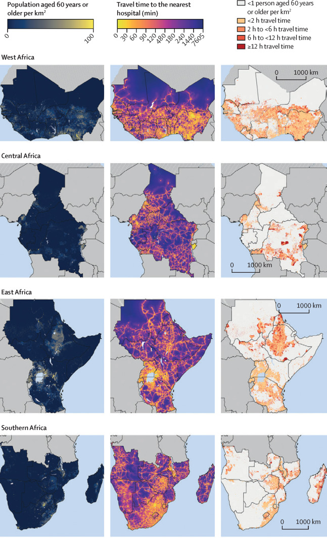
Our results show that almost 10% of adults aged 60 years or older have an estimated travel time to the nearest hospital of 6 hours or longer. Most countries in Sub-Sahara Africa contained populated areas in which adults aged 60 years and older had a travel time to the nearest hospital of 12 h or longer and to the nearest healthcare facility of any type of 6 h or longer.

Future work

We are currently working on improvements on the healthcare provision locations layer and the travel model. This includes an accurate assessment of the quality of healthcare facilities, as well as the travel model underlying data such as the road network. It is important to determine which areas may be over- or underestimated in their healthcare capacity and account for specific needs of care. Our travel model depicts a best case scenario of mobility at a resolution of 1km x 1km. We are working on improvements and adding other approaches on travel time estimations like the openrouteservice ORS isochrone service.

Related work

  • Exploring OSM for healthcare acccess analysis in Sub-Saharan Africa
  • Analysing OSM Completeness of health facilities in Sub-Sahara Africa in ohsomeHeX
  • Exploring OSM history: the example of health related amenities
  • Tools for Disaster Risk Reduction by HeiGIT - Celebrating the International Day for Disaster Risk Reduction

Tags: Accessibility, Health, HealthGIS, isochrones, openrouteservice, OpenStreetMap, OSM, Paper, Public Health, publication, Publications, routin

Posted in OSM, Publications, Research

Comments are closed.

  • About

    GIScience News Blog
    News of Heidelberg University’s GIScience Research Group.
    There are 1,480 Posts and 0 Comments so far.

  • Meta

    • Log in
    • Entries RSS
    • Comments RSS
    • WordPress.org
  • Recent Posts

    • Press release: Understanding the Spatial and Temporal Dimensions of Landscape Dynamics
    • Wanna give feedback about HeiGIT services? Survey Deadline extended to 05.03.
    • An ohsome Railway Network Visualization and Analysis
    • Humanitarian OSM Stats: How to monitor humanitarian mapping in the HOT Tasking Manager? - Part 3
    • ISCRAM GIS Track: Deadline extended for WiP and Practitioner papers: February 21, 2021
  • Tags

    3D 3DGEO Big Spatial Data CAP4Access Citizen Science Colloquium crisis mapping Crowdsourcing data quality disaster DisasterMapping GeoNet.MRN GIScience heigit HOT humanitarian Humanitarian OpenStreetMap team intrinsic quality analysis landuse laser scanning Lidar Mapathon MapSwipe Missing Maps MissingMaps ohsome ohsome example Open data openrouteservice OpenStreetMap OSM OSM History Analytics OSMlanduse Quality quality analysis remote sensing routing social media spatial analysis Teaching terrestrial laser scanning Twitter VGI Wheelchair Navigation Workshop
  • Archives

    • March 2021
    • February 2021
    • January 2021
    • December 2020
    • November 2020
    • October 2020
    • September 2020
    • August 2020
    • July 2020
    • June 2020
    • May 2020
    • April 2020
    • March 2020
    • February 2020
    • January 2020
    • December 2019
    • November 2019
    • October 2019
    • September 2019
    • August 2019
    • July 2019
    • June 2019
    • May 2019
    • April 2019
    • March 2019
    • February 2019
    • January 2019
    • December 2018
    • November 2018
    • October 2018
    • September 2018
    • August 2018
    • July 2018
    • June 2018
    • May 2018
    • April 2018
    • March 2018
    • February 2018
    • January 2018
    • December 2017
    • November 2017
    • October 2017
    • September 2017
    • August 2017
    • July 2017
    • June 2017
    • May 2017
    • April 2017
    • March 2017
    • February 2017
    • January 2017
    • December 2016
    • November 2016
    • October 2016
    • September 2016
    • August 2016
    • July 2016
    • June 2016
    • May 2016
    • April 2016
    • March 2016
    • February 2016
    • January 2016
    • December 2015
    • November 2015
    • October 2015
    • September 2015
    • August 2015
    • July 2015
    • June 2015
    • May 2015
    • April 2015
    • March 2015
    • February 2015
    • January 2015
    • December 2014
    • November 2014
    • October 2014
    • September 2014
    • August 2014
    • July 2014
    • June 2014
    • May 2014
    • April 2014
    • March 2014
    • February 2014
    • January 2014
    • December 2013
    • November 2013
    • October 2013
    • September 2013
    • August 2013
    • July 2013
    • June 2013
    • May 2013
    • April 2013
  •  

    October 2020
    M T W T F S S
    « Sep   Nov »
     1234
    567891011
    12131415161718
    19202122232425
    262728293031  
  • Recent Comments

    GIScience News Blog CC by-nc-sa Some Rights Reserved.

    Free WordPress Themes | Fresh WordPress Themes